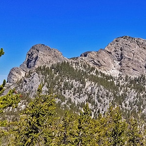
The route to the base of McFarland Peak via the Bristlecone Pine and Bonanza Trails is a true show stopper! Most of the route winds through an ancient pristine Bristlecone Pine forest. As if that were not enough, all along the way there are spectacular views including Mummy Mountain, the North Ridge of Kyle Canyon from Mummy Mountain to Lee Peak and then on to the summit of Charleston Peak, the Sisters Peaks bordering Lee Canyon, Pahrump Valley and Telescope Peak in the Panamint Range on the far side of Death Valley as a faint high point in the background and of course the full spectacular Western side of McFarland Peak with its sheer majestic cliffs.
Take Hwy 95 North from Las Vegas and take a left at the Lee Canyon Road exit (Hwy 156). Travel up Lee Canyon Road to the Upper Bristlecone Pine Trailhead which is at the end of Hwy 156 near the Ski complex. The trailhead is well marked.
On this day I set out from the Upper Bristlecone Pine Trailhead intending to take the Bristlecone Pine Trail to the Bonanza Trail and all the way to Bonanza Peak. This would have been a 24-26-mile round trip including multiple dramatic ascents and descents of 1,500 feet. I found that the higher altitudes which averaged around 9,500ft plus the distance plus the multiple long ascents required better conditioning than I had attained at this point. My highest altitude of the season was around 8,000ft and longest distance about 15 miles. So, I turned around at the far side of McFarland Peak, still equaling around 15 miles out and back.
The first choice to make on this route is whether to begin at the Upper or Lower Bristlecone Pine Trailhead. On this day I chose the Upper Bristlecone Pine Trailhead as a starting point for these reasons:
With all those positive reasons for selecting the Upper Bristlecone Pine Trailhead, next time I might try the Lower Bristlecone Pine Trailhead for one main reason: It’s a wider fire road. It was a problem returning at a run down the narrow Upper Bristlecone Pine Trail. Many of the hiker groups, large and small, were not happy to let a runner pass by. And when you’re tired at the end of a long hike/run you don’t have a lot of energy to negotiate multiple passageways around hikers. The Lower Bristlecone Pine fire road trail would not have had this problem. Oh well, you learn! And, I’m always glad to see people out in nature enjoying the wilderness! No complaints, just a tweak in future strategy.
Once you reach the Bonanza Trailhead 2 miles from the Upper Bristlecone Pine Trailhead the route begins to dramatically ascend with numerous switchbacks. In the meantime, the spectacular Bristlecone Pine forest deepens and the show-stopping views mentioned above increase! I could have been a hundred miles from civilization, so pristine was the wilderness there. The sights and smells were those of an alpine mountain forest, flowers in bloom, Bristlecone Pines in all stages of development from saplings all the way to majestic intricate burnished wooden skeletons twisted into thousands of unique artistic designs.
McFarland Peak is quite the fortress with cliffs all around. I hear some consider it as the most difficult peak to climb in Southern Nevada. The key to the climber’s route appears to be a “gully” on the far Northwest side of the peak. The gully is a kind of chute that gets you close to the class 3 scrambles over the headwall just below the summit. The gully is reached by circling around and behind the far left side of the massive rock bluff on the Northwest side of McFarland Peak. I reached the entrance to the gully and scoped it out briefly today. I’ll return another day to push further up the gully toward the summit.
In all, this section of the Upper Bristlecone Pine and Bonanza Trails is pretty incredible. It feels like another universe from the Charleston Loop. Yes, both are in the Spring Mountains, both are Bristlecone Pine forests. However, it just feels different, more pristine, untouched…hard to explain!


Return often to experience one new adventure each week! From the home page scroll to “Most Recent Adventures“. More about David Smith…
The trail adventures on this website require proper conditioning, preparation and safety precautions. There are many factors beyond our control including weather conditions, unstable ground, loose rocks, insects and snakes, people you may encounter, your own level of physical conditioning, the potential of getting lost just to mention a few. While this site offers guidance, helpful tips, direction and training, the reader assumes full responsibility for whatever may occur during their trail adventure. Have fun and be safe!