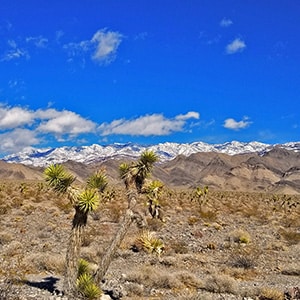
Cow Camp Road is a branch off of Alamo Road (at the 12-mile point) in the Desert National Wildlife Refuge in Southern Nevada. On the Northern tip of the Sheep Range the 5.7-mile long Cow Camp Road provides a great approach to the Sheep Peak trailhead, Sheep Peak being the 2nd highest point in the Sheep Range at 9750ft. The trailhead elevation is about 5,750ft. In addition there are camping areas in and beyond the canyon pass on Cow Camp Road and beautiful views of the Northern area of the Sheep Range. I took the trip up Alamo Road on a mountain bike, then ascended Cow Camp Road on foot so there are ample 360-degree video views along the way.
Take I-95 North from Las Vegas (about 30 miles from the Strip) where you will see a brown highway marker for the Desert National Wildlife Refuge on Corn Creek Rd. Take a hard right onto Corn Creek Road (there’s not a freeway exit ramp, just a sharp right turn). Continue about 3 miles up Corn Creek Road to the Desert National Wildlife Refuge Visitor Center where there is usually ample parking. Just beyond the center you will see a directional sign for the 100s of miles of unpaved 4WD roads in road system for the refuge. Take a left onto Alamo Road and proceed up Alamo Road for 12 miles to the well-marked right turn entrance of Cow Camp Road. There is parking here and I assume this is a great jumping off point for ATV vehicle exploration up Cow Camp Road.
Cow Camp Road ascends gradually toward the Northern tip of the Sheep Range. You’ll pass through a canyon along the way (about 2 miles up Cow Camp Road) where there are designated camping areas. It appears the canyon would provide some shelter from the wind and heat common to this area. As you ascend Cow Camp Road turn around to see spectacular views of the Mt. Charleston Wilderness before entering the upper canyon and after emerging from the canyon.
I left my mountain bike behind to ascend Cow Camp Road on foot, thinking that the unpaved roads in this area would have gravel so deep that ascent on foot would be faster than ascent on a mountain bike. So, I actually made a bee-line across the desert toward the canyon at the 2-mile point. Later, returning down the full length of Cow Camp Road it became clear that the road condition was very stable and good for mountain bike travel…in fact better than Alamo Road where the gravel is actually deeper. Traveling up Cow Camp Road on foot or vis mountain bike might take a similar amount of time. But the return trip down Cow Camp Road via mountain bike would probably save over an hour!
The upper end of Cow Camp Road beyond the canyon is magical. You’re in a fairly untouched, high desert zone with almost alpine views of the Northern tip of the sheep range. There are more designated camping areas near the end of Cow Camp Road and many approaches into the hills for wandering and discovery.
Near the end of Cow Camp Road there is a left fork that leads to the Sheep Peak trailhead. On this day I took the right fork which ends at a corral at the base of a cliff. I understand that one could ascend the rocks here and reach a spring (“Cow Camp Spring”?) in less than 1/2 mile. More exploration to come! I’m looking toward a hybrid adventure here that involves mountain biking up Alamo Road, then Cow Camp Road to the Sheep Peak Trailhead, then ascent to Sheep Peak on foot.


Return often to experience one new adventure each week! From the home page scroll to “Most Recent Adventures“. More about David Smith…
The trail adventures on this website require proper conditioning, preparation and safety precautions. There are many factors beyond our control including weather conditions, unstable ground, loose rocks, insects and snakes, people you may encounter, your own level of physical conditioning, the potential of getting lost just to mention a few. While this site offers guidance, helpful tips, direction and training, the reader assumes full responsibility for whatever may occur during their trail adventure. Have fun and be safe!