Overview | Mummy Mountain Summit from Lee Canyon | Mt. Charleston Wilderness | Spring Mountains, Nevada
The Goal
You will be able to navigate from
Lee Canyon Road pass to the South of
Mummy’s Head, then continue straight up to the summit of
Mummy Mountain. I once looked down from the West edge of
Mummy Mountain summit through what looked like a canyon that could traverse the route from the summit to
Lee Canyon Road. See the
Mummy Mountain North Rim adventure. Will that canyon provide a passage? Let’s find out! The lower 50-75% of this route was achieved in the “
Initial Exploration” (below).
Route Summary
This adventure takes you up a canyon wash on the far Northwestern edge of
Mummy Mountain. Though the wash is filled with boulders, branches and tree trunks, one can find a pretty easy class 2 stairway dramatically ascending upward through unique climate and plant life zones from the beginning of the adventure at 8,000ft on
Lee Canyon Road to the 11,532ft summit of
Mummy Mountain. Of course, expect a few of
Mummy Mountain’s signature avalanche slopes. There are spectacular views all the way up including various approaches to
Mummy’s Head from Lee Canyon Road along this route. Looking back down across Lee Canyon one can see
The Sisters Peaks,
McFarland Peak and the ridgeline of the
Bonanza Trail.
You’ll Be the Only One There
The route is untouched, unoccupied and peaceful. Don’t expect to see anyone in this canyon, even on the busiest weekend days during the height of the climbing season. If anyone has traveled this route before, there is no trace. You get the feeling of covering ground that has never been traversed, though I’m sure I’m not the very first person to ascend this summit approach. Though, I’m likely the first to provide this extensive level of documentation.
See also
Mummy Mountain’s Head from Deer Creek Road and
Mummy Mountain’s Head from Lee Canyon Road.
Directions to Start Point | Mummy Mountain Summit from Lee Canyon | Mt. Charleston Wilderness | Spring Mountains, Nevada
Take
Hwy 95 North from
Las Vegas for about 10 miles past the residential developments. Turn left onto
Lee Canyon Road (after the
Desert National Wildlife Refuge exit). Begin from a large parking area on the West side of
Lee Canyon Road (Hwy 156) about a mile past its intersection with
Deer Creek Road (Hwy 158).
↓ Narrative Guide ↓
Narrative Guide | Mummy Mountain Summit from Lee Canyon | Mt. Charleston Wilderness | Spring Mountains, Nevada
Initial Exploration
Through the Summer Homes Area and to the Canyon Wash
Cross
Lee Canyon Road and navigate the main Summer home resident road (
Avalanche Trail Road) to the right and upward. This road will soon veer to the left as a 4WD road beginning at the last Summer home. Then, the 4WD road will become a use trail. Continue up the use trail until it hits the rugged wash. Now, you’re basically weaving your way taking the path of least resistance up the main canyon wash sometimes on the right, sometimes crossing over to the left then back to the right side, the use trail appearing and disappearing.
Canyon Wash Becomes Pretty Wild and Secluded
Eventually you’ll reach a 10ft barrier ledge with a blue drainage pipe protruding. At this point circle around and above the ledge to the left. Looking carefully you’ll see the bypass use trail. Duck through an overhang and continue up the wash. For about 1/4th mile you can avoid the wash by skirting it to the left. However, when the left side becomes a steep avalanche slope descend into the wash again and continue upward. The wash is pretty easy to navigate and there are step ways through every barrier.
Canyon Wash Splits – Take the Right Branch
Watch carefully for the split where the larger wash branches off to the left toward the
Mummy’s Head area. A faint wash will appear branching off to the right. Continue up this wash to the right, it will soon become more pronounced. At the split, the wash will begin to ascend more dramatically, though there are always boulder stairs to be found, though many require a 2-foot high step. It’s class 2 climbing at this point. There is a large
limestone barrier about 1/2 mile up that requires navigation out of the wash to the right to circumvent. But the wash continues above. You’re in a beautiful transition zone between
Ponderosa Pines and
Bristlecone Pines.
Navigating the First Two Major Barriers
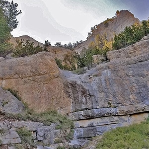
Shortly after the large boulder you will find yourself facing a rather imposing
limestone cliff wall. Navigate around and above this wall via some rather steep avalanche slopes to the left. Hug slopes at the lower base of the cliffs that line the canyon. You’ll emerge above the first cliff wall and be confronted with a more gentle rock wall. This wall looks pretty much class 3, and the rock surface has a lot of traction. The right side of this section looks a bit more gentle than the left. The terrain above this
limestone cliff wall appears to level out a bit, but who knows? More surprises may appear ahead! Be sure to turn around and look back down across
Lee Canyon at this point for spectacular views of The Sisters Peaks, the
Bonanza Trail ridgeline and
McFarland Peak!
Turn-Around Point for This Initial Adventure and Route Timing
I reached my turn-around point here today due to an event I had to attend later in the afternoon. The exploration to this point took about 3 hours. The next trip will be faster and allow more time to continue the ascent to the summit (pending appearance of additional barriers). The return trip took between 1.5 and 2 hours.