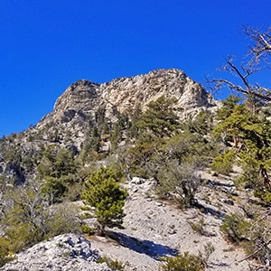
Cockscomb Peak and Ridge is little over a 4-mile round trip with a nearly 3,000ft elevation gain. Stretching from Hwy 157 Northward up to its highest elevation of 9692 ft, it creates a beautiful and rugged feature that can be viewed in a unique way from every high point in the canyon.
As of the writing of this article there were no trails between Hwy 157 (Kyle Canyon Road) and Cockscomb Peak and Ridge, which makes the approach, especially from Hwy 157, a great opportunity to practice some light wilderness navigation skills. The final mile up to the summit from the Hwy 157 approach affords spectacular views of Mummy Mountain, Fletcher Peak, Harris Mountain and the Griffith/Harris Circuit, Griffith Peak and the lower South ridge of Kyle Canyon. It’s like being on a mountaintop for that entire stretch!
There are at least 2 routes to Cockscomb Peak and Ridge. To descend onto the ridge from the North, take the Trail Canyon Trailhead in Charleston Village, Nevada. For directions to the trailhead, see the Mummy Mountain West page on this site.
To ascend to Cockscomb Peak and Ridge from the South, take Hwy 157 to Charleston Village, pass Fletcher View Campground on your left, then park at a wide spot on the right side of Hwy 157 just past the Rainbow Subdivision turnoff and Bristlecone Pine Rd turnoff (see the video for more detail).
After parking in the Trail Canyon Trailhead parking lot, head up Trail Canyon Trail. In about 2 miles you will arrive at the junction of the North Loop Trail. When going to Mummy Mountain, you took a left at this junction. When going to Fletcher Peak you continued straight at the junction. For Cockscomb Ridge and Peak, take a right at the junction.
The trail is unmarked, but you’re on a ridge and it’s pretty obvious that you need to stay on that ridge because you’re faced with a pretty serious drop-off to the right and to the left (more to come).
Lower Stretch with Unmarked Trails
Take the middle of 3 trailheads in this parking area (see the video). Continue up a decent wash which actually has some good solid ground along with a few of the customary rocks and twists and turns of a wash. The wash will meet a better trail–actually an old dirt road in about 1/4-1/2 mile. Turn right onto the wider road and continue another 1/4 mile passing a wash to the left and continuing on up the old road until you see a wider spot with a u-turn trail to the left (see the video).
Upper Stretch on the Approach Ridge
Continue up this trail for another 1/4-1/2 mile until you reach a tree with a miner’s claim plaque (see the video and slide show). At the tree leave all trails and precede straight up onto the ridge that will take you up to Cockscomb Ridge and Peak. Use basic navigation skills to stay on the ridge navigating to the right or left of a number of rock formations but all the while staying as high as possible on the ridge.
Landmarks Along the Way
In terms of large landmarks, there are ridges to the right and to the left. On the way up, turn around often to see Harris Mountain and the saddle between Harris Mountain and Griffith Peak. This will be your major landmark on the return trip down the ridge. You’ll use a point just to the right of Harris Mountain as your frame of reference.
There are a few small cairns, but don’t expect to see a cairn at every point the direction is in question. Now and then you’ll see a faint trail or path, evidence you are not the first person to travel this stretch of wilderness.
With careful navigation, you can get all the way up this ridge without exposing yourself to a fall. Respect the vegetation and try to stay on the rocks vs. trampling plants.


Return often to experience one new adventure each week! From the home page scroll to “Most Recent Adventures“. More about David Smith…
The trail adventures on this website require proper conditioning, preparation and safety precautions. There are many factors beyond our control including weather conditions, unstable ground, loose rocks, insects and snakes, people you may encounter, your own level of physical conditioning, the potential of getting lost just to mention a few. While this site offers guidance, helpful tips, direction and training, the reader assumes full responsibility for whatever may occur during their trail adventure. Have fun and be safe!