Overview | Red Rock Summit | Lovell Canyon & Rainbow Mountain Wilderness, Nevada
Red Rock Summit is a high point on the Wilson Ridge just North of Rocky Gap Road and nearly directly above that road’s summit at the Bridge Mountain Trailhead. Ascending Red Rock Summit from the Bridge Mountain Trailhead area may require advanced rock climbing skills to navigate the vertical headwalls near the summit.
For the above reason, my suggested strategy is to ascend a gradual approach ridge running parallel and just North of Rocky Gap Road from a start point down in Lovell Canyon. Navigating the approach ridge can be complicated, but it’s all class 2 level climbing: Basically, a long, steep, pathless endurance walk with an approximate overall 3,000ft ascent.
The Wilson Ridge experience is marked by long, complicated wilderness approach ridges.
- The primary navigational strategy is to always be aiming for the next high point on the ridge, with no specific idea of what’s beyond.
- Try to stay in the center of the ridge as you weave around brush and rock formations, watching for that next open stretch that will take you through a bit further.
- Develop skills of maintaining stability as you ascend steep, loose rock slopes.
- Do not put your full weight on any object you are not 100% certain is firmly anchored down.
- Be respectful not to disturb any living thing in this wild environment, leaving no trace of your passage.
Once you’ve achieved the Wilson Ridgeline, assess how close you are to your turn-around point because it will take nearly as long to navigate the approach ridge you just traversed, or the next approach ridge back down to Lovell Canyon Road. You don’t want to be navigating one of these wild approach ridges in the dark!
Endurance is always a factor due to an approximate 3,000ft ascent to the Wilson Ridgeline. And, you were not on a straight line trail. The constant weaving may have easily doubled the distance. Often, your turn-around point is when you’ve finally achieved the Wilson Ridgeline, leaving no time to further explore that ridgeline.
Traversing the Wilson Ridgeline
Having attained the Wilson Ridgeline, the terrain levels off a bit, mainly along the stretches between numerous steep high points, each of which require a 2-400ft ascent and descent. Unless you’re equipped for a multi-day adventure, you are likely to have just enough time left to traverse just a mile or so on the Wilson Ridgeline.
Fortunately, there are numerous fairly gradual approach ridges along the Wilson Ridgeline. There’s likely a descent ridge or two every mile along the Wilson Ridge heading back down to Lovell Canyon. Be aware of the location of these “escape” ridges. Enlarge the map on this page in its terrain view. Watch for the neighboring descent ridges as you are ascending your Wilson Ridge approach ridge.
This is all fairly friendly territory and except for a few very brief spots, your entire experience on the Wilson Ridge and its approach ridges is a class 2 walk. Endurance and smart navigation is the thing.
Wild, Untouched Beauty
All that said, there is incredible value in navigating the Wilson Ridge and its numerous approach ridges!
- You may feel as though you’re standing where no human has stood before, seeing what no human has ever seen before — and there’s a good chance you are right!
- Every growing plant displays a unique beauty that is reserved only for you and the wild inhabitants of which you are now a part.
- You’re walking among limestone slabs that lined the bottom of an ancient sea 450 million years ago. Look closely, and it’s evident you’re not looking at rock slabs, but at frozen mud.
- Look yet more closely to see the numerous ancient sea creatures embedded in that frozen mud.
Expansive Views
It’s like being on a mountaintop the entire way with ever-expanding views opening!
Best Time of Year for Wilson Ridge Adventures
Stay away from mid-Winter snows and mid-Summer heat (which can reach 100 degrees, sapping your endurance). When the temperature in the Las Vegas Valley exceeds 100 degrees, a Wilson Ridge adventure may be too hot, potentially dangerously hot. Winter snow can make the Wilson Ridge and its approach ridges treacherous.
Trailhead Directions | Red Rock Summit | Lovell Canyon & Rainbow Mountain Wilderness, Nevada
Take Hwy 160 from Las Vegas toward Pahrump. The highway ascends over a “hump” (the Potosi Mountain area). There’s a saying around here, “Over the hump to Pahrump”. Well, you’ve just traveled over that hump. Around 4-5 miles from the point where the highway begins to descend toward Pahrump there is a well-marked sign on the right for Lovell Canyon Road.
Views Along Lovell Canyon Road
Lovell Canyon Road is a beautiful stretch passing through a Joshua tree forest that soon becomes populated predominately with junipers and pines. There are ridges and meadows and many camping pull-outs along the way. This stretch reminds me a lot of the high desert area around Bend Oregon. Very open and majestic. All the while you’re looking up at the Spring mountains with Griffith Peak standing prominent. The road has very little traffic and would make a great bike, walking or running route. In fact, what an awesome backdrop for a marathon (pretty easy to add 2 miles to the 24-mile out and back stretch)!
Lovell Canyon Rd/Rocky Gap Road Intersection
Proceed about 9 miles up the well-paved road to park at its unmarked connection with Rocky Gap Road (Forest Road #45549 (see map).
Trail Observations | Red Rock Summit | Lovell Canyon & Rainbow Mountain Wilderness, Nevada
Rocky Gap Road to Approach Ridge Base
This is the easiest part of the adventure. From the intersection of Lovell Canyon Road and Rocky Gap Road, head up Rocky Gap Road for about a quarter-mile. The road will at first angle to the left, then, at the intersection of Hairgrass Road, will take a sharp right to circle the base of the approach ridge. When Rocky Gap Road takes a left at the high point at the base of the approach ridge, you want to look for a route up to the center of the approach ridge. It’s easy and obvious. The approach ridge is immediately to the left of Rocky Gap Road and it’s easy to quickly ascend to the center of the ridge.
From High Point to High Point on the Approach Ridge
Once on the center of the approach ridge, it’s just a matter of staying on the center and heading upward to each of many successive high points. You can’t see beyond any of the high points ahead on the ridge, but just trust, once you summit a high point you’ll see a way to the next high point.
450-Million-Year-old-Fossils
The first substantial high point is marked by a rocky gully that spans the line of ascent to the summit of that high point. Don’t try to ascend the rocky gully. It will slow you down. Rather, skirt the upper left side of the gully to the summit of that high point. This stretch ascending the first high point is filled with limestone slabs embedded with numerous ancient sea fossils, around 450 million years old from the time the earth had just one continent, Pangea. The rocky limestone slabs are solidified mud from the ancient ocean bottom. Sea creatures died, sank into the mud and their shells provided the calcium which worked as glue to solidify the mud. Eventually the tectonic activity of the earth lifted the sea bottom and pushed the frozen mud slabs to 30 and 45 degree angles. Enjoy touching sea creatures and so connecting with an ancient era that predates the dinosaurs!
Navigating Thick Forests and a Narrowing, Rocky Ridgeline
The forest begins to thicken at the summit of that first high point. The terrain is rockier and navigation is a bit more complicated, but a way always opens up before you. As the ridge narrows, at times it becomes a matter of skirting the rocky spine of the ridge to the right or left, avoiding the vertical side, which will change numerous times. There is always an upper side of the ridge that is gradual enough to walk without having to climb over any boulders. You can, if you want, stay on the very narrow spine of the ridge to have a class 3 rock climbing experience. That may or may not slow you down a bit, and it’s a long way to the summit of the approach ridge.
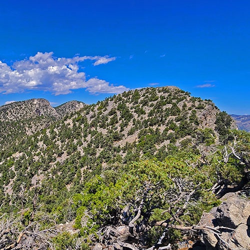
Rocky Spire High Point Just South of Red Rock Summit
There will be times where you can see a sharp rocky spire ahead on the ridge, seemingly hanging over the rocky gap in the Wilson Ridge below. This rocky spire was my high point today. Turns out the rocky spire is immediately above the Bridge Mountain Trailhead at the summit of Rocky Gap Road. Just North of the spire is a more rounded hill, about 200ft higher than the spire and only about 1,000 linear feet from the spire. This more rounded hill is Red Rock Summit. Why I didn’t make that last, fairly easy stretch to the summit is a mystery. I’d reached my turn-around point and decided to head back down the approach ridge.
Future Adventure: Red Rock Summit Loop
This leaves a future adventure circuit ascending the same approach ridge, then traversing the Wilson Ridge for about three high points North, finally descending what looks like a nice gradual ridge heading down to Lovell Canyon Road. I’ll call this The Red Rock Summit Loop. I guess I didn’t take it on this day because the route was uncertain, the time investment was a mystery and I didn’t want to end up on one of these wild ridges in the dark!
Summary of This Memorable Adventure
But, what an amazing adventure. Wilderness that appeared totally untouched, as if I was the first human to tread on that ground, 450-million-year-old fossils, spectacular views up and down Lovell Canyon and to points West all the way to Death Valley’s Panamint Mountain Range and East all the way to the Las Vegas Valley, the Strip, Lake Mead and into Arizona. This adventure is like being on a mountaintop the entire way!