There are 2 main access roads in the Desert National Wildlife Refuge of Nevada: Mormon Well Road and Alamo Road. Each road has a number of tributary roads that lead to various adventures in the refuge–some leading to summits in the Sheep Range and Gass Peak.
My goal is to begin exploring the Desert National Wildlife Refuge by first mountain biking the main roads, then mountain biking the tributary roads. As I travel the roads I’ll be watching for trailheads and mountain summit approaches. Finally, I’ll return to explore the trails and summit approaches.
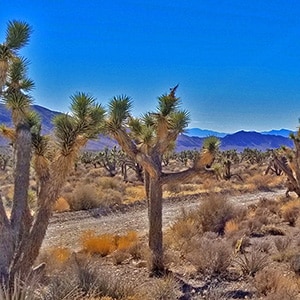
This adventure covers the lower 15-mile stretch of Mormon Well Road from the Desert National Wildlife Refuge headquarters on Corn Creek Road to the intersection of Mormon Well Road and Pine Nut Road. Points of interest are the intersection of Gass Peak Road at the 4-mile point; Yucca Gap between the Southern tip of the Sheep Range and Fossil Ridge at the 5-mile point; and the incredibly massive Yucca Tree Forest spanning the entire Sheep Range valley beyond Yucca Gap. We scope out future adventures on Fossil Ridge, Sheep Range ascent points at the Southern tip of the range and along the Southeastern section and finally, a look at an ascent to Sheep Peak from Pine Nut Road with a return down to Alamo Road.
Take I-95 North from Las Vegas (about 30 miles from the Strip) where you will see a brown highway marker for the Desert National Wildlife Refuge on Corn Creek Rd. Take a hard right onto Corn Creek Road (there’s not an improved freeway exit, just a right turn). Continue about 3 miles up Corn Creek Road to the Desert National Wildlife Refuge Visitor Center where there is usually ample parking. Just beyond the center you will see a directional sign for the 100s of miles of unpaved 4WD roads in road system for the refuge. Take a left for Alamo Road and a right for Mormon Well Road, the two main arteries in the system.
Don’t plan on making any mountain bike land speed records on this 15-mine 2,200ft ascent of lower Mormon Well Road. I’ve run a 26-mile marathon in 3 hours and 18 minutes. This 15-mile stretch took me 5 hours! There are fairly tame portions of road, but also long, steep rocky gravelly sections that bring you to a crawl. I could cover much more ground in this same time were I to run the bike by foot up the steep rocky stretches. Something to try after the plantar fasciitis heals!
Curiously, looking at my close-up shots of Fossil Ridge, it almost looks as if it was once a huge ancient inland sea coral reef. I could be wrong, but the rock looks like frozen coral. See the slide show on this page. We’ll spend an entire day ascending and traversing a large portion of Fossil Ridge at some point this Winter.
The entire adventure is worth it just to be in the midst of the largest Yucca Tree/Joshua Tree forest I have ever seen. This has to be one of the largest on earth. The valley at an average elevation between 4-5,500 feet is the perfect elevation for Joshua Trees. They look like scenes from a Dr. Seuss book.
I’m thinking that a future route beginning at the Desert National Wildlife Refuge Visitor Center, then traveling Alamo Road to Cow Creek Road, then ascending to Sheep Peak followed by a descent to Pine Nut Road and then down Mormon Well Road back to the starting point at the Desert National Wildlife Refuge Visitor Center would be an incredible circuit. One would need to fairy the mountain bike along steep rocky uphill stretches of road and along trails and ridges through the Sheep Range. But the adventure would be a legendary accomplishment.


Return often to experience one new adventure each week! From the home page scroll to “Most Recent Adventures“. More about David Smith…
The trail adventures on this website require proper conditioning, preparation and safety precautions. There are many factors beyond our control including weather conditions, unstable ground, loose rocks, insects and snakes, people you may encounter, your own level of physical conditioning, the potential of getting lost just to mention a few. While this site offers guidance, helpful tips, direction and training, the reader assumes full responsibility for whatever may occur during their trail adventure. Have fun and be safe!