Angel Peak is that observatory landmark one can see from Griffith Peak, Fletcher Peak, Mummy Mountain, La Madre Mountain, Harris Mountain, the Sheep Range, Gass Peak and Northern Las Vegas. There is a rather wild desert area below Angel Peak that can be accessed through the rugged 4WD Lucky Strike Road. Both ends of Lucky Strike Road contain some class 2 climbing sections, so your vehicle needs to be very sturdy. The 3-mile stretch immediately below Angel Peak can be pretty brutal, being a cross between a 4WD road and an avalanche slope! However, the sunset views of the Sheep Range and Gass Peak on that stretch are spectacular, and at night the Las Vegas Valley lights up like Christmas!
I traveled Lucky Strike Road to Angel Peak on a mountain bike, carrying the bike over a few of the more rugged stretches.
I started from the parking area at the intersection of Kyle Canyon Road and upper Harris Springs Road. Take I-95 North from Las Vegas, then take a left under the freeway via the Kyle Canyon Road/Mt. Charleston exit. Continue up Kyle Canyon Road toward Mt. Charleston for about 10 miles to the intersection of upper Harris Springs road.
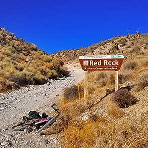
From the intersection of upper Harris Springs Road coast down Kyle Canyon Road about 5 miles to an obscure sign on the left marking “Red Rock Canyon”. That sign marks the entrance to the unpaved Lucky Strike Road. The first stretch ascending the ridge is very steep with a few shallow class 2 ledges. A very good 4WD vehicle could possibly handle this. I lifted my mountain bike up this 200ft stretch. At the top of the stretch the scene opens up to a beautiful Joshua Tree forested valley as Lucky Strike Road continues. The road conditions from here all the way to the final 3-4 miles below Angel Peak are very good for 4WD.
There are a few interesting mountain bike paths that split off from Lucky Strike Road during its initial few miles. I’ll return to try these out.
Lucky Strike Road continues, descending through Goldwater Canyon. Be sure to ascend a few high view points along the way. At the base of Goldwater canyon there is a pack animal corral called Grassy Spring. It looks as if there are a few potential ascent routes to explore the hills above…on foot!
Past Grassy Spring there’s a fork in the road. Head downhill to reach the valley around I-95. If you’re continuing to Angel Peak take a left and continue up. There is an abandoned mine on the hill to the left as you ascend.
Further on there is a 3-mile left turn deviation that will take you up to a dead-end the base of some cliffs. Looks like a beautiful place to camp, but beyond that it leads nowhere.
Continue on Lucky Strike Road past that deviation. This is where I encountered a herd of wild burros near an old abandoned corral. Continue up Lucky Strike Road until there is a crossing. You’ll notice power line poles lining the road that crosses Lucky Strike Road. You can head right and downward toward I-95, or straight further through the desert. I took a left upward toward Angel Peak.
The last 6 miles along this power line road are pretty brutal on a mountain bike, and probably not too easy in a 4WD vehicle. All the vehicles that I encountered were going down hill on this day. I found out why a little further up the road. The last 3 miles up to Angel Peak become a cross between an 4WD road and an avalanche slope! If you’re on a mountain bike, have your pack on your back to keep your bile light as you’ll be lifting it over many obstacles, some of them class 2 climbing! Be sure to look back for spectacular views of the Sheep Range, Gass Peak and the North Las Vegas Valley. Sunset is amazing as the mountains change color and the city begins to light up!
Finally, at the summit of the road, you’re on Angel Peak. You have a few choices:
I continued down the paved road to make a left on Deer Creek Road, then down to Kyle Canyon Road for another left, and finally to my starting point at the parking area on upper Harris Springs Road. The entire trip took me 14 hours due to the left turn deviation (1hr) and ascending the 3-4 mile stretch of avalanche road at the base of Angel Peak with a loaded bike. I could have saved at least 2-3 more hours by putting my pack on my back! Still, even on a good day with excellent strategy, plan for about 8-10 hours on a mountain bike for this grand circuit.


Return often to experience one new adventure each week! From the home page scroll to “Most Recent Adventures“. More about David Smith…
The trail adventures on this website require proper conditioning, preparation and safety precautions. There are many factors beyond our control including weather conditions, unstable ground, loose rocks, insects and snakes, people you may encounter, your own level of physical conditioning, the potential of getting lost just to mention a few. While this site offers guidance, helpful tips, direction and training, the reader assumes full responsibility for whatever may occur during their trail adventure. Have fun and be safe!