Overview | Upper Crest Ridgeline: Mt Wilson to Hidden Peak | Rainbow Mountain Wilderness, Nevada
The Rainbow Mountains Upper Crest Ridgeline from Mt. Wilson to Indecision Peak is very seldom traversed, so there is a feeling of being the first person to walk that stretch of wilderness. This in itself makes for an incredible adventure. The adventure ends with a spectacular view of Hidden Peak, the surprise region at its Northern base and the Southern stretch of The Rainbow Mountains Upper Crest Ridgeline.
Spectacular Views on This Adventure
But there are other values to this stretch of wilderness. Along the way you will see Mt. Wilson and First Creek Canyon in all their glory from a few unique perspectives. In addition, you’ll look DOWN to a very cool potential class 2-3 approach to Indecision Peak’s summit. Expect incredible views throughout Southern Nevada and all the way to Telescope Peak in Death Valley. Views include, Lovell Canyon, Charleston Peak, Griffith Peak and Mummy Mountain, Red Rock Canyon, Turtlehead Peak, The La Madre Mountains, Damsel Peak, Las Vegas Strip, Potosi Mountain, The Rainbow Mountains Upper Crest Ridgeline to the North including Rainbow Mountain & Bridge Mountain. And there’s far more…too much to list here!
Introducing Little Zion!
Then, there’s the spectacular vista between Indecision Peak and Hidden Peak, nearly directly below. I used to refer to this area as “The Gap”, meaning the only major gap in The Rainbow Mountains Upper Crest Ridgeline. All other portions of the Upper Crest Ridgeline are up in the 7,000ft range with some dips and climbs along the way between Buffalo Wall at the North end of the Ridgeline and Highway 160 at the South end of the ridgeline. That is, until you arrive at a pretty substantial 1000ft plummet between Indecision Peak and Hidden Peak.
However, the phrase “The Gap” is totally wrong! It implies a blank space…a space to be traversed in order to arrive at the next important location: Hidden Peak. Nothing could be further from the truth. One of my video viewers pointed out that this “Gap” is one of the most amazing wilderness areas in Nevada. It is referred to as “Little Zion”. To give this wilderness area the attention it deserves, I’m saving it for its own adventure…or a few adventures.
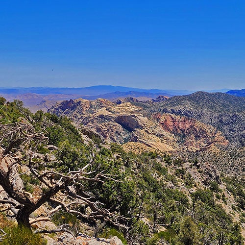
Views Across “The Little Zion Gap” in The Rainbow Mountains Upper Crest Ridgeline
By the way, across “The Little Zion Gap” you not only see views of Hidden Peak and Monument Peak, but also Black Velvet Peak, Windy Peak and Hollow Rock Peak!
So, this current incredible adventure traverses the Rainbow Mountains Upper Crest Ridgeline from Mt. Wilson to the South edge of Indecision Peak where there is a spectacular view of “Little Zion” and across to Hidden Peak, Monument Peak and the Southern stretch of The Upper Crest Ridgeline.
Best Time of Year for This Adventure
Try to stick to Spring or Fall. Summer temperatures can rise to 100 degrees or more, and Winter can bring snowy and icy slick conditions on The Rainbow Mountains Upper Crest Ridgeline, and if you slip and fall, just realize, there are no soft landings!
Trailhead Directions | Upper Crest Ridgeline: Mt Wilson to Hidden Peak | Rainbow Mountain Wilderness, Nevada
Take Hwy 160 from Las Vegas toward Pahrump. The highway ascends over a “hump” (the Potosi Mountain area). There’s a saying around here, “Over the hump to Pahrump”. Well, you’ve just traveled over that hump. Around 4-5 miles from the point where the highway begins to descend toward Pahrump there is a well-marked sign on the right for Lovell Canyon Road.
Locating the Intersection of Lovell Canyon Road and Saltgrass Road
Proceed a couple miles up the well-paved road to Lovell Canyon Campground. You will park at the intersection of Lovell Canyon Road and Saltgrass Road which will be on the right. However, there is no sign that says “Saltgrass Road”. Your only indication that you are at the intersection of Lovell Canyon Road and Saltgrass Road is a small marker on the right indicating Road: #45540. If you’re going to proceed from this point on foot, find a place to park near that intersection. Saltgrass Road, #45540. is the best starting point for this adventure.
Route Observations | Upper Crest Ridgeline: Mt Wilson to Hidden Peak | Rainbow Mountain Wilderness, Nevada
Establishing Your Point of Reference
It seems this day was a story of getting off-track, and in the process making new incredible discoveries. It’s important to note a huge landmark at the start/end point of this adventure. There is a long bluff just West of The Lovell Canyon Campground, parallel to Lovell Canyon Road. Saltgrass Road #45540, branches off toward The Rainbow Mountains Upper Crest Ridgeline at the North end of the bluff, which, incidentally, you can see throughout a good portion of this adventure. This makes it possible to always find your way back home no matter how many twists and turns lie ahead!
May Flowers in Lovell Canyon
It was the last weekend in May, so the flowers in Lovell Canyon were at their brilliant best! Flower viewing along Salt Grass Road from Lovell Canyon Road to The Upper Crest Ridgeline slowed me down a bit, distracting my route focus.
Ascending to The Rainbow Mountains Upper Crest Ridgeline
Then, I wandered off to an Upper Crest Ridgeline approach ridge, one ridge further South than I had planned. This landed me on the Ridgeline above the South edge of Mt. Wilson. No problem. I was going to head North (left) on the Ridgeline. Instead I decided to head South (right) toward Indecision Peak, the next peak South.
Traversing The Upper Crest Ridgeline Above Indecision Peak
There is a pretty imposing height in the Ridgeline above Indecision Peak just South of Mt. Wilson, and no visible trail. Traversing that height above Indecision Peak calls for picking out a “best route”. It’s a matter of knowing when to stay high on the ridgeline and when to dip down a bit to the right (West). Dip a bit downward as you’re approaching that high point, then ascend to the upper center of the high point for a truly spectacular view, then dip down again.
Though there are no trails, there is what looks like a very faint pathway…at least a fairly level strip…along the West side of the Ridgeline. Try to follow this strip as it meanders, alternately ascending and dipping. It’s pretty obvious what you’re attempting to avoid: The sheer drop-offs on the East edge of The Ridgeline (to your left) and the steep scree slopes and drop-offs on the West side (to your right). Just know, there is a sort of path way and you can do it without exposing yourself to a potential fall or attempting anything beyond class 2 climbing (no hands needed).
Follow the Eastern (left) Bend in the Ridgeline
Once you pass that high point of The Ridgeline just South of Mt. Wilson, dip down a bit, then follow the ridgeline around as it bends to the left (East). As the ridgeline bends, spectacular views of “The Little Zion Gap” and the peaks of the Southern Rainbow Mountains Upper Crest Ridgeline appear in all their glory!
Framed Views of Mt. Wilson and an Arch
Just beyond the bend in the ridgeline, ascend to the ridgeline summit for another spectacular view North to Mt. Wilson and beyond through an opening beautifully framed by surrounding pines. There’s also a small, but cool arch in a rock formation not far below.
Indecision Peak Summit Approach
A little further along…like less than 200ft, you’ll come upon a ridgeline access to Indecision Peak’s summit, just as The Upper Crest Ridgeline takes another bend to the right to continue South! On this day I took a right here and headed down a ridge continuing South along The Rainbow Mountains Upper Crest Ridgeline. One could continue South along the Ridgeline, soon to descend into The Little Zion Gap in the ridgeline just below Hidden Peak.
Return Canyon Wash Toward Lovell Canyon
Instead, I took a right (West) and headed down a canyon that looked as if it were aimed back toward Lovell Canyon and my start point at The Lovell Canyon Campground. After around a half-mile, I was able to descend into the base of the canyon which, except for a few easy to bypass obstacles, began to widen out to eventually become a very wide, nicely graded wash route downward toward Lovell Canyon. The meandering wash did prove to be much longer than it had originally appeared. At every bend it looked as though the canyon wash was about to open into Lovell Canyon. Instead, the canyon wash continued toward a further bend. Many many additional bends ahead!
Follow the Wash
Though I could not see my start/end point landmark bluff from within the canyon wash, I was operating on an assumption, which turned out to be correct, that the water that had formed the wash was following its path of least resistance down into Lovell Canyon. Follow the wash!
Cross-Country Route Across Lovell Canyon Back to the Start/End Point
Finally, just before the canyon was truly ready to empty into Lovell Canyon, I headed Northwest (right) across the final low ridge toward my start/end point reference: The North side of that long bluff just West above Lovell Canyon Road and Campground. What an incredibly huge, beautiful field of tall grass waving in the wind! After crossing this field, there was a similarly huge field of sage. Finally, about 1/8th mile from my start/end point on Lovell Canyon Road, I arrived on familiar roads that would take me to the end point.
Final Note on Maintaining Assurance and Confidence
In the end, here are the resources that enabled me to be lost at times without being worried:
- Start/End Point Landmark
- Following Canyon Washes Downward, Out of the Mountains
- Base Conditioning: I run an average of 5 miles/day
- 4 Liters of Water: I ended up consuming 3.5 liters!
- Familiarity with Distant Landmarks: I don’t use GPS, but instead am familiar with distant landmarks in all directions. They keep me on course.
- Sunny Day: The distant landmark strategy works only when there is high visibility, which is about 95% of the time in Southern Nevada!