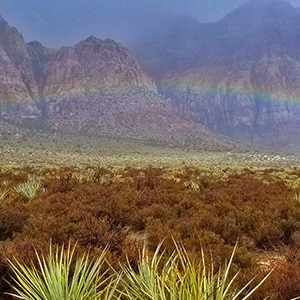
Overview | Middle Oak Creek Trail | Rainbow Mountain Wilderness, Nevada
This brief adventure is an illustration of how rain has shaped and is continuing to shape the desert environment.
The Adventure Route
The route goes from the
Middle Oak Creek Trailhead on
Hwy 159 in
Red Rock Canyon to the entrance of
Oak Creek Canyon. At the canyon entrance the thick clouds above let loose and sent water cascading from the surrounding cliffs. There were waterfalls everywhere, lining the cliff faces!
The Significance of Observing the Powerful Action of Water
It doesn’t rain very often in the desert. Yet to walk in the desert on a typical sun pounding day is to observe the power of water:
Lower Open Canyon Washes
You can’t walk very far without crossing a canyon wash. It’s clear by the smooth stones in the wash and the many channels that you’re in a dry riverbed. The surrounding walls carved out by the action of water can be vertical cliffs towering tens of feet high. It’s breathtaking to imagine water rushing down such a channel! And that channel has been carved out in the relatively flat open surrounding desert.
Red Rock Wash is a good example, and a great way to experience this wash is by taking the
Grand Circle Loop Trail. Another great example is in taking the
Three Basin Circuit which follows open canyon washes in
Red Rock Canyon, over to the
Brownstone Basin and ends in the
Calico Basin. These low, wide open washes are very dry and primarily populated by plants that can survive and even thrive in arid environments:
Cacti,
Yucca,
Joshua Trees and
Creosote. I took time to photograph and name many blooming Spring wildflowers around lower
Juniper Canyon in the Slide Guide on that page.
Upper Sandstone Canyon Washes
The powerful action of water is even more astonishing in the
upper canyons between the
high sandstone peaks of the
Rainbow Mountains. Here you can find huge house-sized blocks of limestone and sandstone that have fallen from the cliffs above. The more I observe these massive canyon boulders it becomes apparent that there is more than one force that landed them in their current resting place in the wash. The powerful action of water is one force, loosening their hold on the cliffs above until they finally gave way. But it seems there are too many huge boulders in the washes. It’s almost as if they broke loose in a large cataclysmic event, or series of events such as earthquakes. After all, this is the region of the
Keystone Thrust Faultline.
However, on a day like today during a strong rainstorm the action of water in forming the canyons, cliffs and ledges is all around. To walk across the huge sandstone slabs on the upper slopes is to see evidence of the action of water. See the
Rainbow Wall via Pine Creek and Oak Creek Canyon adventure, and in particular, observe the action of water in forming the spectacular
Terrace Canyon.
Vernal pools (Tinajas) create their own unique life zones. The
Calico Tanks are a great example.
Notice how the canyons themselves become clothed in the splendor of colorful wildflowers in the Spring. And when it appears the washes have completely dried in the Summer and Fall months, water continues to flow hundreds of feet underground. Some plants like the
Gambles Oak have adapted with roots that reach down as much as 300ft to the flowing water. Brush in the upper canyons, fed by the water flowing beneath, can grow to form barrier walls 40ft high! A great example of plants in the upper canyons is the upper
Red Rock Wash on the North Sandstone Peak Loop. There I take time to photograph and name the wonderful variety of plants in the wash. Also, there are photos of the fantastic designs water has etched into the sandstone boulders. See the Slide Guide on the North Sandstone Peak Loop Page.
Deluge in Oak Creek Canyon
For today, the powerful action of water is all around cascading from the cliffs and ledges above at the entrance of Oak Creek Canyon. This is a rare window into the work of water, which normally you can only observe by the evidence that remains.
Directions to the Start Point | Middle Oak Creek Trail | Rainbow Mountain Wilderness, Nevada
From
I-215 take the
Charleston Blvd exit (at
Red Rock Casino) and head upward through
Summerlin toward
Red Rock Canyon National Conservation Area. Continue upward on
Charleston Blvd. as it becomes
Hwy 159 passing through
Red Rock Canyon. Along the way you’ll pass the entrance to
Calico Basin, the entrance and exit to the
Red Rock Canyon Scenic Drive. Now you’re rounding the high point on
Hwy 159 as it turns to the left and begins to skirt the base of the colorful
Rainbow Mountains. Watch for a trailhead sign and parking area indicating
The Middle Oak Creek Trail.