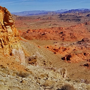

Anniversary Ridge | Muddy Mountains Wilderness, Nevada
Overview | Anniversary Ridge | Muddy Mountains Wilderness, Nevada
Slide Guide Coming Soon!
Anniversary Ridge, the highest overlook point in its area on the Eastern border of the Muddy Mountains Wilderness, offers a spectacular aerial view of the Bowl of Fire, almost immediately below, and views all the way to Lake Mead and beyond! The route described in this article is perhaps the shortest, easiest route to the summit of Anniversary Narrows Peak, a high point on Anniversary Ridge.
Adventure Route Summary
From the parking area at mile 16 on Northshore Road, head up Callville Wash Road, then take a left onto Anniversary Mine Road. Take a right (Northeast) onto the large wash that crosses Anniversary Mine Road. Continue up that wash until it reaches a vertical barrier at the base of a large, dark colored hill on your right (East). Head up and over the left side of that hill, then angle to the left (North) up slopes to Anniversary Narrows Peak, a high point now visible on Anniversary Ridge. Return by the same route. For clearer directions enlarge the map on this page.
Geological History in Your Face!
Nowhere is the geological activity of plate tectonics so upfront and in your face as when youโre heading along this route toward Anniversary Ridge. Plate tectonics is the compressive forces generated when tectonic plates collide, causing the rock layers to fold and tilt, resulting in mountain building events. When tectonic plates interact, they exert stress on the Earth’s crust, causing the rock layers to deform (strain) into folds or faults. To look at the South end of Anniversary Ridge is to see a series of distinct horizontal layers pushed upward on the ridgeline to angles of 45 degrees or more. The summit assumes a jagged sawtooth shape caused by the compressive anticline force.
In fact, the entire route you will be following to Anniversary Narrows Peak is filled with this example of geological history. Youโll see huge blocks of sediment forced upward into sharp angles and, in places, scattered upon the ground.
Spectacular Views During This Adventure
Here is a short list of the spectacular views you will experience on the way to Anniversary Narrows Peak and on the summit of the peak.
- Southern Bowl of Fire
- Northern Bowl of Fire
- Lake Mead
- Hamblin Mountainย
- Callville Bay Area
- Fortification Hill
- Black Mesa
- Muddy Mountains
- Anniversary Narrows Upper Opening
- Virgin Mountain Wilderness
Best Time of Year for Anniversary Ridge Adventure
Due to excessive heat from late Spring to early Fall, the best time to explore Anniversary Ridge is from Late Fall to Early Spring.
Trailhead Directions | Anniversary Ridge | Muddy Mountains Wilderness, Nevada
- Start on Northshore Road traveling North
- Take a left at mile 16 onto Callville Wash Road North (unpaved road)
- If you do not have 4WD there is a wide area for parking at the beginning of Callville Wash Road North. On the other hand, if you do have a 4WD or high centered vehicle, follow the next bullets.
- Head up Callville Wash Road North
- Take a left onto Anniversary Mine Road
- Park near where a large wash crosses Anniversary Mine Road
Route Observations | Anniversary Ridge | Muddy Mountains Wilderness, Nevada
Getting Your Bearings
Begin by getting your bearings of the surrounding reference points. The best observation point for this early assessment is about a half-mile up Anniversary Mine Road.
So, from the parking area on Northshore Rd. Mile 16, head up Callville Wash Road North for about 500ft, then take a left onto Anniversary Mine Road. Continue up Anniversary Mine Road until the point where the first large wash crosses the road. You’re going to take a right and head up that wash, but first get your bearings.
In the distance up the wash you’ll notice a large dark hill. To the left of that hill is a lighter-colored ridgeline on the horizon. That ridgeline is Anniversary Ridge. You’re going to head up the wash, round the left side of the dark hill, ascend the slope to the right of the wash, then at the top of that slope, head up additional slopes, more gradual in the beginning, toward a high point on the lighter-colored ridge which is Anniversary Narrows Peak. See the map on this page for more route detail.
Wash on Anniversary Mine Road to the Left Edge of the Darker Hill
Once you turn right off Anniversary Mine Road onto the wash, you’ll find the wash is easy to navigate with few if any barriers along the way. It gets a bit bouldery as you approach the left edge of the large dark hill. It’s a good time to leave the wash as you round the corner of the dark hill. If you continued in the wash, you would likely hit some vertical dry falls. On the other hand, there is a gully to your right that runs up the North edge of the dark hill.
From the Wash to the Rocky Ridgeline Above
Begin ascending the slope just to the left of that gully. Notice a distinctive rocky area at the summit of that slope. Circle the left side of that rocky area. There, you will encounter a low rocky ridgeline (around 10ft high). As you summit that ridgeline at a point that offers good hand and footholds, you can see your route all the way to Anniversary Narrows Peak, a high point on the Anniversary Ridgeline horizon to the North (slightly to your right). You’ll notice the terrain ahead is at first gradual, gentle slopes becoming steeper as you near Anniversary Ridge.
Rocky Ridgeline to the Base of Anniversary Ridge
Descend the gradual slope on the opposite side of the low rocky ridgeline you are on, cross a shallow gully and begin ascending the slope above toward Anniversary Narrows Peak on the Anniversary Ridgeline. At the first high point on that slope an spectacular view of the Southern Bowl of Fire opens up along with a view of the Northern Bowl of Fire cliffline in the distance. Looking upward toward Anniversary Narrows Peak the slope is at first gradual, but will soon sharply ascend to the next highpoint before Anniversary Narrows Peak. It might help to see this route detailed in the video on this page.
Slope To Anniversary Narrows Peak
From the first high point on the slope you can see another intervening high point toward Anniversary Narrows Peak. The slope is at first gentle, but will get steeper as it ascends toward that next intervening high point. It remains class 2 (no hands needed), but will require weaving and zig-zagging through the boulders on the slope. At the intervening steep high point, you can look across to a more gentle slope ascending to a shallow saddle to the left of Anniversary Narrows Peak. Head for that saddle, then take a right up to Anniversary Narrows Peak!
That final rise to Anniversary Narrows Peak requires balancing along some huge blocks, but this is not difficult. The huge blocks appear to have been uplifted from a lakebed below by the force of plate tectonics described above. The ridgeline is narrow, but you need not be exposed at any point to a fall of more than a few feet. The summit of Anniversary Narrows Peak is pretty obvious with its summit box and the view ahead and behind on the ridgeline being very cliffy.
Anniversary Narrows Ridgeline Beyond (Northeast of) Anniversary Narrows Peak
To proceed beyond Anniversary Narrows Peak looks like a class 3 or higher climbing adventure. Perhaps a class 2 route could be found. It just didn’t look like that was possible and I was out of time. I did see ahead the point where I had summited the ridgeline a few years earlier after having navigated through Anniversary Narrows slot canyon. It’s a nice saddle on the ridgeline directly above the Southern Bowl of Fire. But descending to that saddle looks a bit dicey! If you could descend to that saddle, you could then descend the opposite side of the ridgeline (the route I originally took to the saddle) and continue to and through Anniversary Narrows slot canyon, back to Anniversary Mine Road and ultimately back to today’s starting point. This variation would give you an awesome experience of Anniversary Narrows slot canyon.
Is the Lower Entrance of Anniversary Narrows Slot Canyon Open or Closed???
However, it seems always a question whether the lower entrance to Anniversary Narrows slot canyon is blocked off. I’m constantly hearing rumors that it’s blocked off, but have never found that to be the case. On the other hand, if you descended all the way to the lower entrance of Anniversary Narrows slot canyon and there found it to be blocked off…bad bad! What a long return journey back to your starting point!! Better to inspect the lower entrance to Anniversary Narrows slot canyon ahead of time and verify whether or not it’s open!
The View from Anniversary Narrows Peak
Back to where you’re standing on Anniversary Narrows Peak, and what you can see. It’s spectacular! There’s the jagged saw-toothed terrain on Anniversary Ridgeline, mostly to the Southwest. But look over at the blue waters of Lake Mead standing out in sharp contrast to the surrounding desert environment! Then, there’s Callville Bay, Fortification Hill in Arizona…beyond, Hamblin Mountain and its ridgeline to the left and the Virgin Mountains way further on the horizon on the left.
To the Northwest are the Muddy Mountains in all their glory. Almost directly below are the badlands leading to the now visible upper entrance of Anniversary Narrows slot canyon. And you can look back along the entire route you took to get to Anniversary Narrows Peak. That’s probably a good idea in order to see your way back home!
Alternate Return Routes
Now there are alternate return routes I did not take today. In addition to the Anniversary Narrows Slot Canyon return, another very promising route is to begin descending from Anniversary Narrows Peak. Just below that steep intervening high point angle over to your left toward the Southern Bowl of Fire. Descend into the bowl and circle around the left side of the large pointed peak bordering the East side of the bowl, then return to Callville Wash North Rd., taking a right onto that road to end up at your starting point at Northshore Road Mile 16. This variation would give you an awesome experience of the Southern Bowl of Fire!ย
Retracing Your Approach Route
Now, about 45 minutes beyond my turnaround time, I headed back along the approach route which, from Anniversary Narrows Peak, was visible all the way back to Anniversary Mine Road.
Conclusion
Congratulations on completing this incredible adventure! Along the way you’ve also noticed a number of future adventure routes. In fact, take a close look at the large white sign on Anniversary Mine Road. It identifies a number of different rocks and minerals you can find in the area. And, as long as you only use hand tools, it appears you can find and keep a few cool rocks! In addition, you’ll also find the historic Oar Car Mine in the area. Much additional exploring to be had!