Overview | Red Rock Summit Loop | Lovell Canyon, Nevada
Unique, Spectacular Wilderness
The Wilson Ridge, located on the East side of Nevada’s Lovell Canyon, is wild, spectacular and largely untouched, undiscovered. It’s a wide-open new opportunity to experience a very unique slice of Southern Nevada wilderness. And, from the Wilson Ridge you will view near and distant wilderness landmarks from this entirely unique perspective.
Why is the Wilson Ridge Seldom Visited?
So, why do few, if any people ever experience the Wilson Ridge? Here are a few reasons:
- The Wilson Ridge does not lead to any of the most popular high mountain peaks: For example, Charleston Peak, Griffith Peak, Mummy Mountain. The one high peak, Harris Mountain, that sits at the summit of the Wilson Ridge is possibly the least visited major peak in the Mt. Charleston Wilderness.
- There are no trails on the Wilson Ridge: If you’re traversing the Rainbow Mountains Upper Crest Ridgeline, at least there is a faint trail. And you can descend from that ridge to the popular peaks in the Rainbow Mountains such as Bridge Mountain and Mt. Wilson.
- Series of imposing high points along the Wilson Ridge: The Wilson Ridge is far from an easy walk. Each of the many sharp high points along the ridge are individually challenging adventures in themselves. And while I’m finding that the high points are not as imposing when you’re on them as they look from a distance, just looking across the ridge with its frequent mountainous high points can feel exhausting. It takes time to traverse each individual high point, and your time is already running short after traversing a long approach ridge.
- The approach ridges are very long, leaving little time to explore the Wilson Ridge: By the time you ascend to the Wilson Ridge, you have only enough time left to traverse a brief stretch of the ridge unless you’re planning a multi-day adventure. So, it takes multiple trips to a complete the entire Wilson Ridge. Just ascending to the Wilson Ridge requires more than twice the time and effort compared to ascending Griffith Peak!
- Isolation: If you get into trouble on the Wilson Ridge, help may be unavailable.
All these factors contribute to the relative isolation of the Wilson Ridge. On the helpful side, each of the many sharp high points on the ridge have fairly gradual, but somewhat complicated descent ridges back to Lovell Canyon.
Wilson Ridge Adventure Strategy
All these factors have helped formulate my Wilson Ridge strategy, which is to traverse short one-two-mile stretches on the Wilson Ridge until I have completed the entire ridge.
Red Rock Summit Loop Route Summary
This particular stretch, the Red Rock Summit Loop traverses a mile or so of the Wilson Ridge North from Rocky Gap Road, taking in 4 high summit areas on the ridge. After ascending the long, somewhat complicated approach ridge running parallel to and above Rocky Gap Road, reach the Wilson Ridge summit at a jagged rocky high point above the Bridge Mountain Trailhead on Rocky Gap Road. Then head left (North) to the next high point, Red Rock Summit. Summit two additional high points to the North, then descend a long gradual, less complicated ridge back to Lovell Canyon Road at its intersection with Forest Road #25930, about a mile from your starting point at the intersection of Rocky Gap Road (Forest Road #45549).
The video and detailed adventure description on this page begins on the Wilson Ridge just South of Red Rock Summit. To see how I got to that location, view the previous adventure entitled: Red Rock Summit.
As mentioned before, the views are unique and spectacular, the wilderness pristine and beautiful and there’s even rocky limestone band of 450-million-year-old sea fossils on the route both up and down the approach ridges! And since it’s a loop adventure, you can do this with one vehicle parked at the start/end point.
Best Time of Year for This Adventure
Stick to Spring or Fall to avoid Winter’s slick, icy conditions on those rocky high points along the ridge and Summer’s high heat which can approach 100 degrees. However, pick a day with a lot of sunlight as you’ll need the better part of a long day to complete this adventure. You don’t want to be caught trying to traverse this pathless wilderness in the dark!
Trailhead Directions | Red Rock Summit Loop | Lovell Canyon, Nevada
Take Hwy 160 from Las Vegas toward Pahrump. The highway ascends over a “hump” (the Potosi Mountain area). There’s a saying around here, “Over the hump to Pahrump”. Well, you’ve just traveled over that hump. Around 4-5 miles from the point where the highway begins to descend toward Pahrump there is a well-marked sign on the right for Lovell Canyon Road.
Views Along Lovell Canyon Road
Lovell Canyon Road is a beautiful stretch passing through a joshua tree forest that soon becomes populated predominately with junipers and pines. There are ridges and meadows and many camping pull-outs along the way. This stretch reminds me a lot of the high desert area around Bend Oregon. Very open and majestic. All the while you’re looking up at the Spring mountains with Griffith Peak standing prominent. The road has very little traffic and would make a great bike, walking or running route. In fact, what an awesome backdrop for a marathon (pretty easy to add 2 miles to the 24-mile out and back stretch)!
End of Lovell Canyon Paved Road
Proceed about 9 miles up the well-paved road to park at its unmarked connection with Rocky Gap Road (Forest Road #45549 (see map).
Route Observations | Red Rock Summit Loop | Lovell Canyon, Nevada
Additional Reference: Red Rock Summit: This adventure will get you up to the Wilson Ridgeline.
Arrival on The Wilson Ridge High Above the Bridge Mountain Trailhead
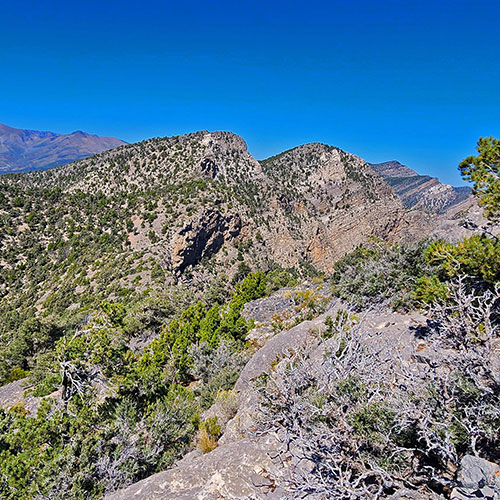
So, you find yourself on what looked like a sharp rocky pinnacle from below. Standing on that pinnacle, it seems more like a long rocky summit area. You’re looking almost directly down on the Bridge Mountain Trailhead far below on Rocky Gap Road. Looking South you can see the Wilson Ridge it’s sharp high points continuing across Rocky Gap Road. The “Rocky Gap” is actually this major break in the Wilson Ridge. Looking North, there is a large rounded hill just ahead and about 2-300ft higher. This hill is Red Rock Summit, your next destination.
Navigating to Red Rock Summit
With the Wilson Ridge and its approach ridges, you can never see more than a few hundred feet ahead, and it always looks as if you’ll be stopped by an adventure-ending ledge around the next corner or beyond the next high point. However, my experience is that as you round that next corner or summit that high point, the next stretch will open up before you without exceeding the class 2 climbing level. Getting to Red Rock Summit is no exception. Just carefully read the terrain and press on until you are standing on Red Rock Summit.
Unique, Spectacular Views from Red Rock Summit
The 360-degree view from Red Rock Summit is even more spectacular. What most impressed me is the crescent shape of the La Madre Mountains cliff line, the complete view of the Rainbow Mountains Upper Crest Ridgeline all the way from White Rock Mountain at its Northern point to Indecision Peak far to the South, the expansive view of upper Lovell Canyon with the Wilson Ridge ascending to Harris Mountain on the Eastern border and Sexton Ridge ascending to Griffith Peak on the Western border. Then, looking West directly across Lovell Canyon to ridge systems I have not yet traversed between Lovell Canyon and Trout Canyon to the West.
Descending the North Side of Red Rock Summit
Descending the North side of Red Rock Summit involves navigating steep, loose rock. Your best strategy here and elsewhere on the Wilson Ridge is to stay as close to the upper cliff line on your right as possible. Progress seems to be easier along the upper edge. Just don’t get too close to the edge as the drop-off is life-terminating and everywhere the surface is loose rock. Leave a safety zone, a few feet of space between you and the cliff edge. Still, there’s a broad, fairly easy strip of ground just above that cliff edge. On the other hand, if you stray down to the left on the ridge, you’ll find yourself traversing a very complicated loose rock slope, measurably slowing your progress, limiting your view and sapping energy.
There’s a short saddle between the Northern base of Red Rock Summit and the next high point on the Wilson Ridge. Looking back at the North side of Red Rock Summit, it seems so steep you may find yourself wondering how you descended that cliff-like slope. Yet while you were on it, the slope did not seem as difficult.
Is it Possible to Descend from the Wilson Ridge to Rocky Gap Road?
A word about that cliff line to your right as you traverse the Wilson Ridge: I’m always watching for the possibility of a descent route to Rocky Gap Road. The best possibilities often occur at the saddles. Perhaps a gradual gully descent? However, along the stretch of Wilson Ridge I traversed during the Red Rock Summit Loop, I did not see any potential descent route to Rocky Gap Road that appeared to be less technical than the class 4 or 5 level of rock climbing. Perhaps there is a descent route to Rocky Gap Road much further North above the North Peak Trailhead area.
Descent from the Next High Point North of Red Rock Summit Looks Problematic
The next high point is a lower summit between two much higher points on the Wilson Ridge. As with all the high points on the ridge, there is a descent ridge leading back to Lovell Canyon Road. I would not take the descent ridge at this next high point as it’s shorter, steeper and lands you at the base of Lovell Canyon still a mile from Lovell Canyon Road. I’m thinking that the terrain down there is going to include a lot of complicated rocky washes and thick brush.
2nd High Point North of Red Rock Summit Has a Great Descent Ridge!
So, after topping the lower summit North of Red Rock Summit, continue toward the next, much higher summit with what looks like a nice, gradual descent ridge. The imposing headwall guarding that next summit will melt away as you get closer, and you’ll find yourself standing on that high summit without any climbing above the class 2 level. This high point is actually a couple hundred feet higher than Red Rock Summit with a more expansive view North along the Wilson Ridge.
The great news is that the long descent ridge back to the base of Lovell Canyon that looked so gradual and easy actually turns out to be so! In fact, as you descend that ridge, in many places you will be able to follow a faint trail that is a welcome experience after navigating the long pathless wilderness to this point. It looks as if people who camp below near the intersection of Lovell Canyon Road and Forest Road #25930 at the base of this descent ridge may ascend the ridge, camp along the way and enjoy its summit at the Wilson Ridge. I did see some nice camping spots along this ridge.
Descent Ridge Levels Out, Wide Path Appears
As the descent ridge levels out about a mile from Lovell Canyon Road, a wide path that looks like it has accommodated OHV traffic at some point appears, taking you all the way to Lovell Canyon Road.
Looping Back to Your Starting Point at the Intersection of Rocky Gap Road
Once you reach Lovell Canyon Road at its intersection with Forest Road #25930, it’s just a matter of heading left down Lovell Canyon Road for a mile to complete the Red Rock Summit Loop at your starting point on the intersection of Lovell Canyon Road and Rocky Gap Road (Forest Road #45549).
Congratulations! You’ve completed a grand adventure in a pristine wilderness with unique, spectacular 360-degree views: The Red Rock Summit Loop!