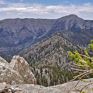
With its spacious wide-open atmosphere and its majestic bristlecone pine forests, Mummy Mountain is the most beautiful summit in the Mt. Charleston Wilderness. But the cliffs just below the summit have their own pristine beauty. They are largely untouched and unvisited, offering peaceful solitude, spectacular views and huge unique ancient bristlecone pine trees seemingly growing out of the tall cliffs. Some of the ledges can be narrow and a bit challenging. Others are wide enough to pitch a tent or enjoy a unique restful incredible view. Much of the area at the base of Mummy Mountain’s summit cliffs gives you the impression of being the first person to ever stand in that place.
Cliff ledge areas that you can easily navigate as a hiker can abruptly end with class 5 climbing beyond, so it’s important to know and stay within your limits. My limit is mostly stretches I can walk along with a few scrambles, but none with any major exposure.
Views from the Northwestern cliffs include the South ridge of Kyle Canyon, Charleston Peak, Lee Peak and the North ridge of Kyle Canyon from Lee Peak to Mummy Mountain. In the distance you can see the Pahrump Valley and faintly Telescope Peak on the far side of Death Valley. Directly below is Lee Canyon, the Lee Canyon ski area, Bristlecone Pine Trail, Bonanza Trail and that trail’s ridge including McFarland Peak and continuing on to Bonanza Peak. There are many more points of interest, but these are the main ones I can identify at this time.
The route I took on this day to the summit is the route beginning at the Trail Canyon Trailhead just beyond Charleston Village in Kyle Canyon, described and documented by video on the Mummy Mountain West page of this site.
From the Trail Canyon Trailhead, head up Trail Canyon Trail. The ascent is steep and relentless up to the junction of the Trail Canyon Trail, the North Loop Trail and Cockscomb Ridge Trail, about 2 miles from your starting point. It’s another mile up the North Loop Trail to Cave Springs. There is a hollowed out log water basin along the trail fed by a trickle of water piped down from Cave Springs. The log basin is dry for much of the year but seems to be full from late Spring to the end of the Summer.
Continue up the North Loop Trail for another mile or so to the huge skeleton of a bristlecone pine tree marked with an “M” and an arrow pointing up the avalanche slope to the right. I call this slope “The Horrifying Half” because it is composed of loose rock with a pretty dramatic incline that rises nearly 1000ft in about a half mile. In the video I give my strategy for navigating the rocky surface without slipping and sliding. Basically, stick to the larger rocks to the right on the way up. Look for impressions or “steps”. The larger rocks are more stable. On the way down go with sections of deep small gravel rock. You’ll easily slide to a halt with each step and can keep up a fairly good pace. Both ascending and descending AVOID sections of hard dirt covered with a thin layer of fine rock. These can easily become like a skating rink an you’re sure to slip, slide and fall!
At the summit of The Horrifying Half you are on the North Ridge of Kyle Canyon. The views include Kyle Canyon from Griffith Peak to Charleston Peak on one side and Lee Canyon on the other side. The bristlecone pines are huge, artistic and beautiful from this point onward. Incidentally, if you were to take a left on this ridge you could continue along the ridge all the way to Lee Peak. I’ve documented this stretch on the 4 Peak Circuit page of this site.
If you’re heading up to Mummy Mountain, take a right at the top of the ridge and continue on the ridge top cliffs for about 1/4th mile. Then jog to the left briefly and then take a right at the edge of the ridge up toward the Western cliffs of Mummy Mountain. A trail will appear at this point. Head left along the base of the majestic cliffs which are just below Mummy Mountain’s summit.
In another 1/4th mile you will see a narrow v-shaped opening in the cliffs leading up to Mummy Mountain’s summit and requiring only about 10 minutes of light scrambling…some class 3.
On this day I continued past the v-shaped opening and on along the base of the summit cliffs. There is a ledge at the base of the cliffs. Cliffs above and cliffs below. The ledge is fairly wide except for a few narrow sections. It’s a pretty easy walk for about 1/4 to 1/2 mile. The views are spectacular and the area mostly untouched and untraveled. Eventually you will reach a place where the ledge ends and the only way to precede forward is via class 5 cliff climbing on rock surface with many stretches of fine gravel. I stopped before reaching the class 5 section. However, that half mile of ledge was an incredibly magical stretch between the stark cliffs, the majestic bristlecone pine trees seemingly growing out of solid rock and the spectacular views!


Return often to experience one new adventure each week! From the home page scroll to “Most Recent Adventures“. More about David Smith…
The trail adventures on this website require proper conditioning, preparation and safety precautions. There are many factors beyond our control including weather conditions, unstable ground, loose rocks, insects and snakes, people you may encounter, your own level of physical conditioning, the potential of getting lost just to mention a few. While this site offers guidance, helpful tips, direction and training, the reader assumes full responsibility for whatever may occur during their trail adventure. Have fun and be safe!