Overview | Black Rock Sister | Mt Charleston Wilderness | Lee Canyon | Spring Mountains, Nevada
Non-Stop Spectacular Views Throughout The Black Rock Sister Adventure
If you’re looking for a summit approach in the
Spring Mountains with expanding non-stop spectacular views all the way to the summit after the first brief 1/8th mile,
Black Rock Sister is unbeatable. Views during this adventure will include
Mummy Mountain,
Lee Peak and the
upper ridge of Kyle Canyon spanning the distance between these peaks. You’ll also see
Charleston Peak, The
Sisters North and
The Sisters South,
McFarland Peak and
Bonanza Peak along with the ridgeline of the
Bonanza Trail.
Macks Peak, the
Sheep Range,
Gass Peak, the Northern
Las Vegas Valley, and
Angel Peak will also be visible as you near
Black Rock Sister. And there are many additional points of reference in the distance beyond in all directions.
Elevation and Position of The Black Rock Sister
Black Rock Sister, elevation 9,668ft, in the Lee Canyon area of the
Spring Mountains in Nevada is the little-known orphan of the more popular and noticeable
South and North Sisters. Sitting on a high point in its ridgeline,
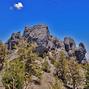
Black Rock Sister appears to be composed of a single solid mass of rock around 60ft high and 150ft wide.
Best Approach Ridge to The Black Rock Sister
The best approach to
Black Rock Sister is a ridge with a very steady rate of incline throughout it’s approximate 1,500ft ascent with negligible incline variation until its final 200ft. This means that the return trip is literally downhill all the way. It therefore makes a great conditioning workout for altitude, strength and endurance.
3-Peak Circuit of the Sisters Peaks: Black Rock Sister, Sisters North, Sisters South
If you want to add to the adventure, the larger
North Sister and South Sister sit on the same ridgeline only about 1/4th mile
South of Black Rock Sister. All three Sisters are fairly equally distanced about 1/4th mile apart.
Best Time of Year to Summit Black Rock Sister
The best time of year to summit
Black Rock Sister avoiding Winter snows and Summer heat is April – June or September – November.
Directions to Start Point | Black Rock Sister | Mt Charleston Wilderness | Lee Canyon | Spring Mountains, Nevada
Take
Hwy 95 North from
Las Vegas. Turn left onto
Lee Canyon Road (Hwy 156). Continue on
Lee Canyon Road about 16 miles. You’ll continue on
Lee Canyon Road past the intersection with
Deer Creek Road. Park at a pull-out on the East (left) side of
Lee Canyon Road about 300ft before reaching the address 5690 on the opposite side of the road. The parking area is generous and can accommodate 15 or more vehicles.
↓ Narrative Guide ↓
Narrative Guide | Black Rock Sister | Mt Charleston Wilderness | Lee Canyon | Spring Mountains, Nevada
From Lee Canyon Road to the Black Rock Sister Approach Ridge
From the parking area, head up
Lee Canyon Road and take a right (West) up a gully wash just before 5690. This is where I headed upward. One gully about 150ft earlier may have been better because the great ridge that takes you all the way to the summit is on the North (right) side of the earlier gully.
Expanding Views of the Eastern side of Lee Canyon
Once you’re on the ridge, the views of the opposite side (East side) of
Lee Canyon immediately begin to open up and quickly expand. Immediately visible are
Mummy Mountain,
Lee Peak and the upper ridge of
Kyle Canyon stretching between. One can scope out various approach routes from the base of
Lee Canyon to the upper ridge of
Kyle Canyon opening up approaches to
Mummy Mountain and all the peaks along the North and South
Charleston Loop Trail. Direct approaches from
Lee Canyon to
Mummy’s Head and
Lee Peak are also visible.
Terrain on the Approach Ridge to Black Rock Sister
The approach ridge to
Black Rock Sister is steady and fairly gradual all the way to the upper saddle between
Sisters North Peak and
Black Rock Sister. There is little loose rock or steep incline until the final 150ft to that upper saddle, and the terrain is wide open making it easily possible to weave through the trees without having to navigate brush anywhere on the ridge.
Easy Jog to the Ridge to the Right (North)
Near the summit of the approach ridge you want to make an easy jog over to the next ridge to the North (right) in order to complete your ascent to the upper ridgeline for the Sisters. This will land you at a high point immediately between the
Sisters North and the
Black Rock Sister. From there you can easily navigate a shallow saddle to the South (left) for the Sisters North or a shallow saddle to the North (right) for the
Black Rock Sister.
Evil Ridge to the North of the Black Rock Sister Approach Ridge: Do Not Descend This Ridge!
Simple enough? Yet here is where I made a mistake on the return descent that I had actually warned against in the video during the ascent! Go figure! As you’re ascending the Disney Land wonderful gradual, open approach ridge I’ve been describing, you’ll notice a disturbing, evil ridge to the immediate right (North). That ridge ends in a rocky drop-off and has long, steep avalanche slope sides. It’s clear that if you were descending that ridge you’d be in for a wild ride.
Remember that easy jog to the right near the summit of the awesomely nice approach ridge. That little jog easily puts you on the evil ridge to the right (North) far above the evil area not far from the summit saddles to the
Sisters North and the
Black Rock Sister. Here’s the rub: On the return descent, if you miss that little jog just below the summit saddles (on the return this is a jog to the good ridge on your right (South), you will continue down the evil ridge eventually ending up at the rocky drop-off and realize you now need to descend a monster avalanche slope which, best scenario, will land you in a gully that will eventually take you to a point on
Lee Canyon Road requiring a over a half mile uphill backtrack up that road to return to your starting point. It’s easy to make this mistake on the return trip. I made the mistake!
Incredible Rock Arch Formation During the Black Rock Sister Approach
Let’s return our thoughts for now to the easy jog you made on the approach trip to the ridge on your right, above the evil part. Once you begin ascending that ridge watch for a huge, incredible
limestone arch formation on the right (North) side of the ridge. A couple additional
limestone pillars will become visible on the same ridge above the
limestone arch and your destination,
Black Rock Sister, is now fully visible.
Arrival at the Upper Saddle Between the Sisters North and Black Rock Sister
Continue past the rock formations to arrive on the upper saddle. The Western view now opens up including
McFarland Peak,
Bonanza Peak and
Macks Peak and distant points beyond including the Northern
Highway 95 corridor. In addition, to the Northeast appear the
Sheep Range,
Gass Peak and the upper
Las Vegas Valley, including points beyond.
Charleston Peak is now visible along with
Lee Peak to the Southeast and the
Spring Mountains stretching to the South.
Arrival at The Black Rock Sister
After viewing the North side of the
Sisters North and contemplating a potential summit approach (the West side of that mountain may also be a good approach), take a right and head down the shallow saddle and then up to the
Black Rock Sister. I circled the
Black Rock Sister to find at least 3 potential class 3 summit approaches. The first begins on the South side immediately at the top of the saddle. Heading around the
Black Rock Sister in a clockwise direction two additional class 3 approaches appear on the North side.
Descent from Black Rock Sister and Return to Lee Canyon Road
If you’re descending back to
Lee Canyon Road, do not head down the ridge below
Black Rock Sister, but retrace your way back to the upper saddle between
Black Rock Sister and
Sisters North, then retrace your way back down the approach ridge remembering to take that jog to the ridge on your right (South) a little below the amazing arch formation.
Alternate Circuit Including Sisters North and Sisters South
On the other hand, if you have a lot of energy and want to extend your adventure, head up to the summit of the
Sisters North, then descend and round the West side of that peak to navigate the saddle to the Western summit of the
Sisters South. You’ll at first be on the West side of the saddle between the two Sisters, but quickly navigate to the East side of that saddle. Once on the Sisters South Western summit, continue down the South side of the
Sisters South to connect with a very fine trail that will lead you down to the
Old Mill Picnic Area on
Lee Canyon Road before taking a left on
Lee Canyon Road to return to the place where you began. See my adventure description from the
Old Mill Picnic Area to the
Sisters South summit.