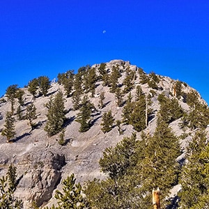
In the rush to get to the summit of Charleston Peak, highest peak in the Spring Mountains of Nevada, most climbers bypass 11,289ft Lee Peak (less than 700ft lower than Charleston Peak), failing to realize it even exists. This is unfortunate because Lee Peak offers at least 2 unique features over Mt. Charleston. First, the view from Lee Peak includes two beautiful canyons: Kyle Canyon and Lee Canyon. All the mountains along both sides of Kyle Canyon are visible (Mummy Mt., Fletcher Peak, Harris Mountain, Griffith Peak and Charleston Peak) and the view is spectacular – right down the middle of the canyon! At the same time, there’s a spectacular view of Lee Canyon including the entire Bristlecone Pine Trail and all the way to the Sheep Range in the distance. In addition, from the summit you can see all the way to Telescope Peak on the far side of Death Valley, and beyond that to the Sierra Nevada range.
The second great feature is that the climber get’s a little experience in wilderness navigation as the two approach routes to Lee Peak are unmarked and must be discovered, which is an enjoyable experience. During this climb I scoped out potential routes from Lee Canyon to the summit of Lee Peak and believe I’ve narrowed it down to one best choice. View the Bristlecone Pine Trail page to see the chosen route from the bottom up. The video on this page shows the chosen route from the top down. View the Lee Peak from Lee Canyon page to see this adventure.
The trailhead to Lee Peak is the Trail Canyon Trailhead. View the Mummy Mountain West page to see directions to that trailhead.
The first part of the trail to Lee Peak is pretty easy. Just take the Trail Canyon Trail up 2 miles to the junction of the North Loop Trail. Turn left at the junction onto the North Loop Trail. Precede past the Mummy Mountain Tree. Continue to wind upward along the North side of Kyle Canyon. The trail will round a corner, Charleston Peak, which disappeared near the Mummy Mountain Tree will again come into view and the trail will level off a bit. I call this the upper North Loop Trail.
As a side note, just about 100 yards after that first view of Charleston Peak you’ll see a small ridge to your right. If you ascend this ridge, you’ll see an abandoned Ski Tower which marks a possible descent route to Lee Canyon.
However, continue on the North Loop Trail which is basically level, though there are some moderate descents and ascents for the next mile. You’ll pass a couple camping spots along the way. Two rocky peaks that look like they could be Lee Peak are not Lee Peak. The sign that you’re getting close is a series of steep switchbacks. A little past the top of these switchbacks there is a pretty substantial viewpoint. You’ll see a small cairn at that viewpoint. Take a sharp right up the hill there which is the Lee Peak approach. You won’t see anything that looks like a trail so from this point you’re navigating rocks and trees and an avalanche slope along the upper left side of a ridge for about 1/4th mile to the summit of Lee Peak. At the summit there is a summit box so you know you’ve made it!
Alternately, you could continue on the North Loop Trail to the South end of Lee Peak (the end closest to Charleston Peak), make a u-turn and head up the ridge to the summit of Lee Peak. This makes a nice little circuit trip up Lee Peak summiting on the Charleston Peak side and then descending the side furthest from Charleston Peak back down to the North Loop Trail. This is the circuit route shown in the video.


Return often to experience one new adventure each week! From the home page scroll to “Most Recent Adventures“. More about David Smith…
The trail adventures on this website require proper conditioning, preparation and safety precautions. There are many factors beyond our control including weather conditions, unstable ground, loose rocks, insects and snakes, people you may encounter, your own level of physical conditioning, the potential of getting lost just to mention a few. While this site offers guidance, helpful tips, direction and training, the reader assumes full responsibility for whatever may occur during their trail adventure. Have fun and be safe!