Overview: Kyle Canyon Grand Crossing North
Adventure Slideshow by 9/23/2022
Grand Crossing Overall Description
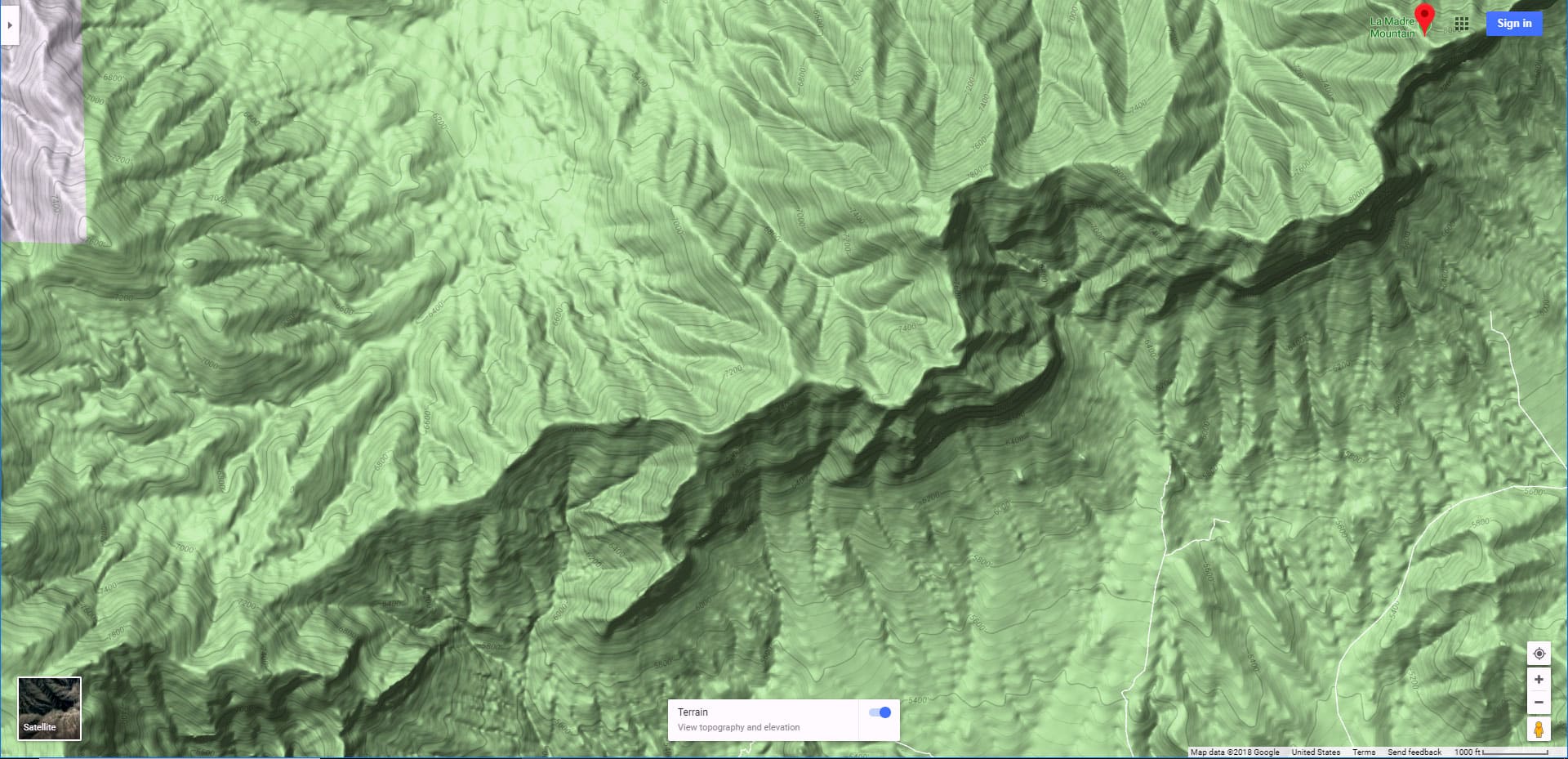
The Kyle Canyon Grand Crossing North is the Northern half of the larger Kyle Canyon Grand Crossing which begins at the intersection of Kyle Canyon and Harris Springs Roads, ascends to the El Bastardo Mountain area on the Keystone Thrust fault line cliffs above Red Rock Canyon, then descends to Red Springs Desert Oasis in the Calico Basin.
Grand Crossing Northern Half Description
This Northern half of the adventure takes you to the saddle between Burnt Peak and El Bastardo Mountain on the Keystone Thrust Ridgeline, looks down to Red Rock Park and contemplates various routes into the park below before returning to the starting point on Kyle Canyon Road.
Highlights of the Grand Crossing Northern Half
Highlights include a walk though the beautiful La Madre Mountains Wilderness camping area, navigating numerous rocky plateaus through the wilderness up the Burnt Peak approach ridge, exploring a section of the upper Keystone Thrust and seeing spectacular 360-degree views all along the route. There are even some fossil sightings along the way. Visible are La Madre Mountain, El Padre Mountain, Burnt Peak, El Bastardo, the entire Mt. Charleston Wilderness, the Sheep Range, Fossil Ridge, Gass Peak, the complete length of Kyle Canyon and much more. And that’s just on the North side of Burnt Peak. Once you top Burnt Peak and look South you’re looking down into Red Rock Canyon, the scenic drive and visitor center, Turtlehead Peak, the Calico Hills, White Rock Mountain, the entire stretch of the Rainbow Mountains and Potosi Mountain at the Southern end. Again, there is much more on the horizon, but these are the most obvious main features.
Distance and Route Challenges
If you begin on foot from the intersection of Kyle Canyon Road and Lower Harris Springs Road count on a 20 Miles + round trip with a 3,400ft ascent from 4,500ft to 7,900ft. The route begins on good roads, then, at the La Madre Mountains camping area becomes pure unmarked wilderness with some light class 3 rock climbing. If you take a 4WD vehicle to the La Madre Mountains Wilderness camping area cut off about 15 miles.
Best Time of Year for the Kyle Canyon Grand Crossing Northern Half
Since you’re starting out at 4,500ft don’t do this in Summer heat. Since it’s such a long adventure, do this on a day with the most hours of sunlight possible. Since Winter may bring snow and ice at the higher altitudes, I recommend doing this adventure in early to mid Fall or mid to late Spring.
Trailhead Directions to Kyle Canyon Grand Crossing North
Take Hwy 95 North from Las Vegas. Take the Kyle Canyon Exit (Kyle Canyon Road) toward Mt. Charleston. About 200 feet beyond the intersection of Kyle Canyon Road and Lower Harris Springs Road park in the large parking area to the right. Note: there’s another Harris Springs Road intersection about 3-4 miles further up Kyle Canyon Road. That is not the parking area I’m describing.
Alternately, if you want to drive as far as your 4WD vehicle can take you and get closer to the actual trailhead at the La Madre Mountains Wilderness campground, you could turn left off of Kyle Canyon Road onto Harris Springs Road. Harris Springs Road is good for 2WD travel. After only 1/8th mile Harris Springs Road takes a hard right. Continue up Harris Springs Road for a couple miles. Pass the first left turn there and continue a couple miles further up Harris Springs Road. Watch for an unmarked left turn onto a rather narrow and rough unmarked 4WD road. Watch carefully! If you blink, you’ll miss it. That narrow 4WD road will take you to an awesome camping area in the La Madre Mountains Wilderness. Park there to begin the adventure described on this page.
Route Observations for Kyle Canyon Grand Crossing North
Under the Stars, Atmospheric Dawn and the Emerging Sunrise
This adventure began at 5:00 am on the 3rd Sunday in September when the sunrise was at 6:25am. So, the first hour and 25 minutes were during night and then atmospheric dawn, the time when light is first appearing on the horizon, but the sun has not yet risen. Traversing lower Harris Springs Road at night was a beautiful, peaceful experience. The desert is more awake at night since life there shelters during the heat of the day and emerges between sunset and sunrise. I could hear animal sounds around me, mostly birds and burros.
The starlit skies were brilliant in the dark of night. One of the slides on this page shows Orion’s Belt in vivid detail. Then, I witnessed the gradual emerging of light on the horizon in colors from crimson to orange to yellow with silhouettes of Joshua Trees in the foreground. That was all happening above and behind me. Ahead, the Mt. Charleston Wilderness was bathed in every variation of red imaginable gradually changing with every passing minute. The desert at night and during sunrise is truly magical!
Finding the Left (South) Turn Toward the La Madre Mountains Camping Area
About 3 miles up Harris Springs Road there is an unmarked narrow 4WD road branching off to the left. There is only one earlier left turn up to this point, but that road is wider and better graded. Watch for the narrow road later that looks almost like a path. It circles around a ridgeline and heads straight for the La Madre Mountains which are now in full view.
4WD Road and La Madre Mountains Camping Area
A couple miles up the 4WD road you will begin entering the La Madre Mountains camping area. There are no services here: No water, electricity…bring everything you need. There are 10 or more camping pull-outs that can accommodate a vehicle and a tent. The area is peaceful, the night sky is brilliant. It must be one of the best kept camping secrets within about 45 minutes of the Las Vegas Strip! It doesn’t look like you need a camping permit, but you might want to check that out.
Solitude Along the Way
Speaking of peace and solitude, for the first 10 hours of this adventure I did not see a soul. The first person I saw was riding a dirt bike through the campground during my return descent. Definitely, do not expect to see anyone during your adventure, especially once you begin to ascend the mountains above the camping area.
Lower Portion of the Burnt Peak Ascent Ridge
At the top end of the 4WD road just above the camping area there is a turn-around. There are no marked trails. Just head up the approach ridge toward Burnt Peak, which is straight ahead on the horizon. The ridge is a 2-3 miles long and contains a series of rises, each getting a bit more rocky than the last until you find yourself doing a little light class 3 climbing (class 3 means you need to use your hands and feet in order to advance). At the bottom of the approach ridge where the road ends, there is a very faint trail which will appear and disappear numerous times. Just stay in the center of the ridge and, if you lose the trail, it will reappear. The trail, though narrow and faint at least guides you through the surrounding trees and brush, which can be thick in places.
Rocky Rises and Scrambles on the Mid-Ridge
After the 3rd rise, the trail disappears for good and the angle of incline increases as the rocky sections appear. Each rise ends with a cliff drop-off and you need to figure out where the opening is that will enable you to avoid a class 4-5 descent. Fortunately, there is always an opening. Curiously, on the return descent, the openings in the rock walls are all clearly visible and easier to navigate. However, the return descent will have its own particular difficulty, which I’ll describe when we get to that point.
Final Approach to Burnt Peak Summit
After the final rocky rise, the final steep approach to Burnt Peak’s summit (about 200ft elevation gain) becomes fully visible. It’s not difficult. Just weave your way upward through the rocks, brush and fallen trees. This is the burn area for which Burnt Peak is named. While the peak area is barren, at least on the North side, which you are ascending, the benefit of this sparse vegetation is that the view is wide open including all the mountains mentioned above.
The Burnt Peak / El Bastardo Saddle
On this day as I approached the summit of Burnt Peak I angled to the right toward El Bastardo Mountain. I decided to scope out the saddle between Burnt Peak and El Bastardo for potential descent routes into Red Rock Canyon or ways to continue West on the Keystone Thrust above Red Rock Park. The area on the Red Rock Park (South side) of Burnt Peak is like being in an entirely different world. It appears that when the fire on Burnt Peak reached the summit, it stopped there leaving the other side of the peak with a beautiful pine forest and spectacular views South. Here, you’re on the edge of a cliff, about 2,500 feet above the upper end of Red Rock Park almost directly below.
Scoping Out Various Potential Routes Down into Red Rock Park (the Southern half of the Kyle Canyon Grand Crossing)
I’ve traversed the Keystone Thrust ridgeline between the Willow Creek picnic area in Red Rock Park and the West side of El Bastardo, leaving about a 1/2 mile gap in the ridgeline around El Bastardo still to be worked out. It looks pretty rugged, but not impassible. On the other hand, it also looks possible to descend from the saddle between Burnt Peak and El Bastardo directly down into Red Rock Park. That stretch is rather steep, but may not require skills beyond class 3 climbing. I want to ascend that stretch before attempting to descend it. That seems a better, safer way of becoming familiar with the steep slope. Easier to reach and navigate a cliff barrier while ascending than to face a sudden drop-off while descending.
Descending Back to the La Madre Mountains Camping Area
So, on this day I turned around at the saddle and descended the Burnt Peak approach ridge back to the La Madre Mountains camping area. As I mentioned, the rocky rises are easier to navigate during the descent. However, there are multiple descent ridge variations and the end target of the small turn-around at the top of the 4WD road is much harder to identify than Burnt Peak summit was as an end point during the ascent! Keep your eye on the ridgeline that extends downward below the camping area all the way to Harris Springs Road. The 4WD road you’re shooting for stretches along the West base of that ridgeline. That creates a better big picture target to shoot for on the way down. And, if you stray down the wrong ridge, just angle back over to that ridgeline.
Getting Back on Course if You Miss the 4WD Road
Worst case scenario…if you’re totally lost just continue downward through ridges and washes until you hit Harris Springs Road. Your going through the lower ridges and washes may be a bit brutal, but you’ll arrive at Harris Springs Road where you with turn right and head back down to Kyle Canyon Road. This is if you’re on foot. If your vehicle is parked at the La Madre Mountains camping area, you’ll need to nail that destination more precisely. Still, not too horribly difficult. I did the complete Burnt Peak descent ridge, rocky portions and all once at night only to the light of a quarter moon. However, I’d navigated that descent previously in the light of the day. Today I nailed the exact upper end of the 4WD road. Previously I missed it and had to traverse wilderness to reconnect with the road, once at night!


