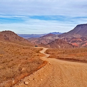
This section of Kingman Wash Access Road is about 4 miles in length. It’s an unpaved road that leads down to the shore of Lake Mead at Temple Bar Marina where there is boating, fishing and hiking. There are 3 additional unpaved roads splitting off to the right. The first is South Mine Access Road; second is North Mine Access Road which later connects with South Mine Access Road and continues on as South Mine Access Road. The third road splitting off from Kingman Wash Road near its end and to the right of a restroom structure is the unpaved Fortification Hill Road which leads to Fortification Hill Trailhead.
Fortification Hill is the large table rock feature to the right of the lower end of Kingman Wash Access Road.
There is a parking area to the left just beyond the entrance of Kingman Wash Access Road. I parked my car there and took the mountain bike up Kingman Wash Access Road. The road itself is very firm–firm enough for a passenger car, however just about every passenger car I saw attempting the entrance to the road quickly turned around. There is a lot of washboard action on the road and rolling hills.
As the road climbs, about 1/4th mile in a small unmarked unpaved road splits off to the left. This is South Mine Access Road. It will ascend rather steeply and at times take on the nature of a “controlled avalanche slope” until it connects with North Mine Access Road and then continues on as South Mine Access Road. Definitely have a 4WD vehicle if you attempt South Mine Access Road. You may do better on an ATV or dirt bike.
Continuing past the intersection of South Mine Access Road, Kingman Wash Access Road rises to a great view of the Kingman Wash area looking toward Lake Mead. Then the road descends a bit and rises again to the intersection of North Mine Access Road. North Mine Access Road is another rough 4WD only road with will ascend to later connect with South Mine Access Road. At a high summit where these two roads converge there are sweeping views of Fortification Hill, the Temple Bar area of Lake Mead, Hoover Dam area and the I-11/Hwy 93 Bridge which crosses the Colorado River from Nevada into Arizona. Just to the lower left of Fortification Hill you can see Black Mesa on the other side of Lake Mead. Further in the distance there is Frenchman Mountain, the Sheep Range, Gass Peak and the Mt. Charleston Wilderness with Mummy Mountain, Fletcher Peak, Mt. Charleston and Griffith Peak. In the opposite direction looking East up South Mine Access Road Mt. Wilson in Arizona is visible. This is a pretty incredible viewpoint. Also, from this high point you can descend South Mine Access Road back down to Kingman Wash Access Road and back out the entrance onto Hwy 93.
Continuing on Kingman Wash Access Road past the intersection with North Mine Access Road, Kingman Wash Access Road begins to dramatically descend to its end at the Temple Bar Marina, a boat launch area on the shore of Lake Mead. The large table mountain feature to the right is Fortification Hill. Near the lower end of Kingman Wash Access Road there is a restroom to the right. To the right and behind the restroom structure is the beginning of Fortification Hill Access Road which in about 2 miles ends at the Fortification Hill Trailhead.
Just before the restroom on Kingman Wash Access Road there are flash flood warning signs cautioning visitors to climb the hills to escape the flood waters, and steep embankments on either side of the road that indicate earlier flash floods roaring down the wash. Flash floods normally occur due to July thunderstorms which could be happening far up the wash. You could be experiencing sunny skies down lower in the wash, unaware of thunder storms far away. The first sign of trouble would be a wall of water roaring down the canyon sweeping you out into Lake Mead! In addition, the Summer months in this area experience temperatures sometimes exceeding 120 degrees. So, you might want to reserve the Kingman Wash area for late Fall through early Spring adventures!
One more note: Down at the Temple Bar Marina boat launch area I saw people enjoying camping, boating, fishing and hiking. All along Kingman Wash Access Road there are pull-outs for camping. In all, it’s a beautiful, stark Arizona desert area, normally with a lot of sun and clear skies.
On this day I did not ascend higher than the viewpoint at the intersection of the North and South Mine Access Roads. That will be a future adventure! My discovery route on this day was to take Kingman Wash Access Road to it’s end at the Temple Bar Marina on the shore of Lake Mead, then retrace my way back to North Mine Access Road, take North Mine Access Road to it’s upper viewpoint intersection with South Mine Access Road, then take South Mine Access Road back down to Kingman Wash Access Road (the 3 roads form a huge triangle) and then back out the entrance of Kingman Wash Access Road.


Return often to experience one new adventure each week! From the home page scroll to “Most Recent Adventures“. More about David Smith…
The trail adventures on this website require proper conditioning, preparation and safety precautions. There are many factors beyond our control including weather conditions, unstable ground, loose rocks, insects and snakes, people you may encounter, your own level of physical conditioning, the potential of getting lost just to mention a few. While this site offers guidance, helpful tips, direction and training, the reader assumes full responsibility for whatever may occur during their trail adventure. Have fun and be safe!