Overview | Mini Matterhorn Pinnacle | Wilson Ridge | Lovell Canyon & Rainbow Mountains, Nevada
Route Summary
This short, but complicated and time-consuming route up a spectacular wild pathless approach ridge takes you to a pinnacle facing a sheer cliff along with dramatic drop-offs to the right and left. The one final approach path to the pinnacle is a narrow rocky spine of a ridgeline. It’s a wonder that one can accomplish this adventure without exceeding class 3 climbing!
Spectacular Views from Mini Matterhorn Pinnacle
As you stand on the pinnacle, if you are able to stand on that small loose rock surface facing sheer and dramatic drop-offs on three sides, the views are spectacular…even from a sitting position!
To the East
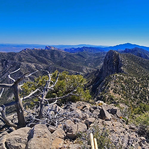
Looking over the sheer Eastern cliff face you can see the Northern stretch of the Rainbow Mountains Upper Crest Ridgeline and Rocky Gap Road winding along its Western base. Beyond is Red Rock Canyon with Turtlehead Peak and the Calico Hills, along with Damsel Peak in the Calico Basin. Beyond, further East, are the Las Vegas Strip, Frenchman Mountain, Sunrise Mountain, Lake Mead and the Muddy Mountains with further reference points in the distance.
To the North
To the North is the Northern stretch of the Wilson Ridge all the way to Harris Mountain. Behind Harris Mountain is Mummy Mountain. Further to the left (Northwest) are Griffith Peak and Sexton Ridge. Below is the Northern stretch of Lovell Canyon. To the right (Northeast) is the La Madre Ridgeline and La Madre Mountains with the Sheep Range and Gass Peak in the distance.
To the South
To the South is the Southern stretch of the Wilson Ridgeline and Lovell Canyon all the way to Potosi Mountain.
To the West
To the West is the Western ridgeline above Lovell Canyon with points beyond all the way to the Panamint Mountain Range on the West side of Death Valley. To the Southwest is the Nopah Mountain Range. There are too many more spectacular reference points to list here!
Wilson Ridgeline Southern and Northern Stretches
The Wilson Ridgeline spans the East side of Lovell Canyon and can be divided into two main stretches: Northern and Southern.
The Northern (upper) stretch of the Wilson Ridgeline
This stretch goes from the Southern High Point to Harris Mountain, the Northern high point at the ridgeline’s summit.
The Southern (lower) stretch of the Wilson Ridgeline
This stretch begins at the Southern High Point and extends to Rainbow Spring Road with major gaps at Rocky Gap Road and South Spring Canyon.
The Gaps in the Wilson Ridgeline
The gaps are so dramatic that it is near impossible to traverse them, making it necessary to begin your ridgeline adventures above and below the gaps. Of course, if you’re a highly experienced technical rock climber you can traverse the gaps, but the time to traverse the gaps may take the better part of a day, leaving little or no time to continue traversing the ridgeline!
Enjoy the Spectacular Approach Ridges and Pinnacles
I’ve found that every approach to the Wilson Ridgeline is so complicated and time-consuming that by the time I reach the ridgeline by any of the access points it feels like it’s time to begin the return trip and there’s little time left to explore the ridge! So, exploring the Wilson Ridgeline may be a matter of enjoying the many spectacular approach ridges that lead to various pinnacles on the ridgeline. Traversing the Wilson Ridgeline between South Spring Canyon and the Southern High Point is an experience of summiting at least three tall sharp Matterhorn-like pinnacles every mile. The Northern ridgeline is more gradual with a faster traverse time.
Of course, if you’re prepared for a multi-day adventure you will have time to traverse large stretches of the Wilson Ridgeline. However, good luck carrying enough water!!
Best Time of Year for Wilson Ridgeline Adventures
Pick the longest days possible (you’ll need a lot of daylight), yet avoid mid-Summer heat and Winter’s treacherous, icy conditions. This leaves late August to the first snows in October or November; and early Spring from snowmelt in late April or early May through mid-June. Carry lots of water and dependable lighting in case you’re still on the ridge after sunset…and plan NOT to be on the pathless wild Wilson Ridge and approach ridges after sunset!
Route Start Point Directions | Mini Matterhorn Pinnacle | Wilson Ridge | Lovell Canyon & Rainbow Mountains, Nevada
Take Hwy 160 from Las Vegas toward Pahrump. The highway ascends over a “hump” (the Potosi Mountain area). There’s a saying around here, “Over the hump to Pahrump”. Well, you’ve just traveled over that hump. Around 4-5 miles from the point where the highway begins to descend toward Pahrump there is a well-marked sign on the right for Lovell Canyon Road.
Views Along Lovell Canyon Road
Lovell Canyon Road is a beautiful stretch passing through a Joshua tree forest that soon becomes populated predominately with junipers and pines. There are ridges and meadows and many camping pull-outs along the way. This stretch reminds me a lot of the high desert area around Bend Oregon. Very open and majestic. All the while you’re looking up at the Spring mountains with Griffith Peak standing prominent. The road has very little traffic and would make a great bike, walking or running route. In fact, what an awesome backdrop for a marathon (pretty easy to add 2 miles to the 24-mile out and back stretch)!
Start Point on Lovell Canyon Road
Proceed about 9 miles up the well-paved Lovell Canyon Road. About a mile past the intersection with Rocky Gap Road (Forest Road #45549) watch for another road turn-off to the right. The sign for Forrest Road #25930 may be hidden in the brush. Find place to park. This is your start point.
Route Observations | Mini Matterhorn Pinnacle | Wilson Ridge | Lovell Canyon & Rainbow Mountains, Nevada
Identify the Approach Ridge While Still on Lovell Canyon Road
As you ‘re driving up Lovell Canyon Road toward the intersection with Forrest Road #25930, be watching for a long fairly gradual ridge ahead and to your right leading up toward the Wilson Ridge. It will help to recognize that ridge before you begin to climb.
Follow An Old ATV Road/Trail to the Base of the Approach Ridge
Once parked at or near the intersection with Forrest Road #25930, head toward the base of the ridge. An ATV road will appear just past the few camping spots closest to Lovell Canyon Road. Head up that ATV road (not sure ATVs are allowed, but it’s apparent their use once formed the road which is much wider than a hiking trail).
High Points and Faint Trails Along the Approach Ridge
In about a quarter to half-mile the ATV road will suddenly disappear. Now you’re right at the base of the initial healthy incline of the approach ridge. Now watch for narrow trails and openings through the trees, brush and boulders on the ridge. This ridge is possibly the easiest of the many approach ridges to the Wilson Ridgeline. All the approach ridges are roughly 2-3,000ft elevation gain and 3 miles in length. What makes this approach ridge the easiest is the presence of various passageways (sometimes even faint trails). These will appear and disappear as you ascend the ridge, so your main guiding principle is to stay on the center of the ridge rather than try to follow a trail.
There will always be a high point ahead, beyond which you cannot see. Only as you top each of the series of high points on the ridge will you be able to see the next stretch. Just know that this ridge continues upward, fairly gradual, with no major barriers, all the way to its connection with the Wilson Ridge.
Establish Your Return Route and Reference Points as You Ascend
As with all approach ridges to the Wilson Ridge, views rapidly become more expansive and spectacular as you ascend. Turn around often to establish a clear picture of the terrain below including the position of your starting point on Lovell Canyon Road and the features of the ridgeline on the across Lovell Canyon. These will help guide your return trip.
Elaborate Camping Spot High on the Ridge
An interesting spot about 2/3rds up the ridge and on one of the high hills is a pretty elaborate campsite for a wilderness area. It appears someone put a lot of effort into designing this site, complete with rock-lined approach trails, a small rock enclosure and a stairway. Someone spent a lot of time at this site. I did not try to establish whether it was modern or historic. My guess is more on the modern side. The view is beautiful, and the elevation would be a welcome escape from mid-Summer heat.
Final Steep, Rocky Knife-Edge Summit Approach
Following the campsite, the ridge takes a small plunge followed by a dramatic increase in the angle of ascent. This steep hill is the final approach to the Wilson Ridgeline. Two things happen at this point: First, the terrain becomes much rockier and second, the approach ridge dramatically narrows, until near its connection with the Wilson Ridgeline it assumes a very narrow edge with sharp drop-offs on either side. Still, the going is fairly easy, class 2-3. You may need to use your hands and do a little light climbing over very brief, shallow rocky inclines.
Arrival on the Pinnacle!
By the time you reach the very summit of the approach ridge…you’ll know you’ve arrived because there’s a sheer cliff drop-off ahead…you’re also looking down at a very steep rocky slope on either side along with that narrow knife-edge final approach behind. And the place upon which you’re standing has just enough room for your feet and maybe a loose rock to sit on! While this pinnacle may not look like the Matterhorn from a distance, from you’re perspective at the summit looking down in all directions it feels like a mini version of the Matterhorn. A fall to your right, left or ahead would be a life-ending experience.
Scoping Out the Wilson Ridgeline from the Pinnacle
The pinnacle gives a great perspective of the Wilson Ridgeline stretching both North and South. To the South is Red Rock Summit followed by a ridge descending above Rocky Gap Road to its intersection with Lovell Canyon Road. You’re route South is by re-descending the knife-edge of the pinnacle to a point where there is a sanely possible opening downward along the Wilson Ridge and that ridge widens out considerably. To the North, progress along the Wilson Ridge is more questionable. There is no wide ridgeline, only steep, loose rock slopes with significant drop-offs to traverse. I decided on this day to head back to Lovell Canyon Road and next time ascend the approach ridge further North and backtrack to this pinnacle. Sometimes the route seems more possible from the other direction, and when you know basically what to expect, it seems more doable.
How Long Does this Hike Take?
The time to from Lovell Canyon Road to the pinnacle on the Wilson Ridge was about three and a half hours. The return trip was faster and easier. The openings and faint trails on the approach ridge are easier to identify while descending, and more of the ridgeline is visible during the descent.
Mini-Matterhorn Pinnacle Summary
In summary, the Mini Matterhorn Pinnacle is a very rewarding hike in itself with an interesting, somewhat challenging approach, non-stop spectacular views and the feeling of being on top of the world at the pinnacle! Plan on total round-trip time possibly exceeding seven hours, and try to avoid being on the approach ridge or Wilson Ridgeline in the dark: Too many hidden drop-offs, many with huge, sheer plunges leading to severe injury or loss of life. That said, in the light of day this is an incredible adventure!