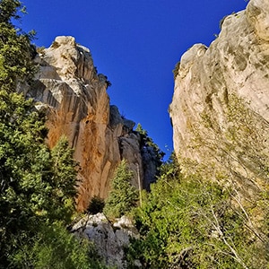
Robbers Roost, located on Hwy 158 just above Kyle Canyon, is a world class rock climbing destination. The mile-long impressive wall of limestone cliffs can be approached via a short 1/4th mile trail which begins on Hwy 158. The trail ends just beyond a huge limestone cave. Here one can continue to ascend a slot opening in the cliff wall by bouldering up approximately 100 yards of huge boulders that are thought to be the collapsed roof of an ancient limestone cave. The views from both the base of the cliffs and above are spectacular including the Mt. Charleston Air Force radar installation on Angel Peak, the La Madre Mountains Wilderness, Lower Kyle Canyon, the Centennial Hills area of the Las Vegas Valley and beyond to the East. As one ascends above the Robbers Roost cliffs the Sheep Range comes into view and the wilderness ridges may continue up to Fletcher Peak, though we have not yet reached that destination via this route.
The wilderness, blanketed by a mature, majestic pine forest, is full of life and the singing of birds can be heard all along the way.
Take the Kyle Canyon Road/Mt. Charleston exit off of I-95 about 20 miles North of the Las Vegas Strip. Just before reaching Charleston Village take a right on Hwy 158 to fine the well marked Robbers Roost trailhead about 5 miles up the road.
On my first visit to the Robbers Roost area I ascended the short trail to the main cave at the base of the slot canyon bouldering ascent to the summit of the cliffs. Recovering from a running injury, I decided not to attempt the bouldering section, but rather to take a right and skirt the base of the cliffs in search of an opening. There are no trails and a lot of avalanche slopes along the base of the cliffs, but the going is not too difficult if you’re used to traversing this type of terrain.
After between 1/2 to 1 mile the cliffs end and there is indeed a way to circle above and continue ascending the steep avalanche slopes. Faint trails appear and disappear along the way providing some relief from the steep angle of ascent. After another mile or so, I crossed a wash and ascended to a viewpoint. From this vantage point the Sheep Range, Charleston Radar Installation on Angel Peak, Centennial Hills in Upper Las Vegas Valley and all the way East to Frenchman Mountain and beyond came into view. Looking down one can see Hwy 158 winding around all the way to the North Loop Trailhead.
I could have continued to ascend beyond this 8,000ft elevation point making my way further toward Fletcher Peak, but called it a day for this initial exploration of the beautiful Robbers Roost area. The trip to the high point took about 3 hours of rather convoluted exploration along cliff bases, up avalanche slopes, over various rock formations and across a wash. The return trip took only 1 hour.
It is important to keep the Charleston Radar Installation on Angel Peak in view as a point of reference along this wilderness route. Once you reach the edge of the Robbers Roost cliffs to begin ascending the avalanche slopes keep the Charleston Radar Installation on Angel Peak directly behind you. On the return trip head straight toward the Charleston Radar Installation on Angel Peak until you again reach the opening at the end of the cliff section. Then circle around to the right and parallel the cliffs, gradually angling downward to eventually reconnect with the Robbers Roost trail just a few hundred feet from the trailhead on Hwy 158.


Return often to experience one new adventure each week! From the home page scroll to “Most Recent Adventures“. More about David Smith…
The trail adventures on this website require proper conditioning, preparation and safety precautions. There are many factors beyond our control including weather conditions, unstable ground, loose rocks, insects and snakes, people you may encounter, your own level of physical conditioning, the potential of getting lost just to mention a few. While this site offers guidance, helpful tips, direction and training, the reader assumes full responsibility for whatever may occur during their trail adventure. Have fun and be safe!