Overview | Mini Matterhorn Pinnacle North Twin | Wilson Ridge | Lovell Canyon & Rainbow Mountains, Nevada
Adventure slide show week of 10/22/23.
Three Pinnacles with Approach Ridges from Lovell Canyon
Ascend the third Wilson Ridgeline approach ridge North of Rocky Gap Road.
- The first approach ridge leads to Red Rock Summit.
- The second approach ridge leads to the Mini Matterhorn Pinnacle.
- This, the third approach ridge leads to the North Twin Pinnacle of the Mini Matterhorn Pinnacle.
It’s a challenge navigating this stretch of the Wilson Ridge North of Rocky Gap Road, marked by tall, sharp pinnacles. Fortunately, every pinnacle has its own fairly gradual approach ridge ascending from Lovell Canyon Road. However, the approach ridges are each 2-3 miles, wild, with stretches choked by brush, and rocky sections to navigate. There are no trails. By the time you get to the Wilson Ridgeline, you may feel it’s time to turn around and head back down the approach ridge.
Each Approach Ridge is a Fascinating Destination in Itself
That said, each of the approach ridges is a destination in itself. As you ascend, spectacular, expansive views of Lovell Canyon continue to open. You’re seeing the wilderness from Potosi Mountain in the South to Griffith Peak and Harris Mountain in the Mt. Charleston Wilderness to the North. And you can see over the Western rim of Lovell Canyon all the way to Telescope Peak in the Panamint Mountain Range on the West side of Death Valley!
Potential Historic Summer Settlements on the Approach Ridges
But that’s not all these approach ridges have to offer. You might be familiar with historic Native American settlements in the Willow Spring area of Red Rock Canyon. It’s known that these were nomadic people who spent the Winter in Red Rock Canyon and migrated “up into the mountains” to escape the heat of the Summer.
Very little has been written about “where” in the mountains the Native Americans may have migrated during the Summer. A great candidate is these approach ridges from Lovell Canyon to the Wilson Ridgeline. The approach ridges are gradual with many wide open areas, some of which look as if they may have been engineered long ago to accommodate living spaces. Places on the ridges appear to have been widened. There are even some primitive stone structures: Stairways, small enclosures.
Temperature Differentials
The difference in elevation between the Willow Spring area in Red Rock Canyon and the Wilson and La Madre ridgelines above is over 3,000ft. Given a 5-degree temperature drop for every 1,000ft elevation gain, the upper ridges are up to 20 degrees cooler than the Willow Spring area.
Settlement Areas on the Third Approach Ridge
This third approach ridge to the Wilson Ridgeline North of Rocky Gap Road has a number of areas that could have been engineered to accommodate settlements. These are pictured in the video and slide show on this page.
Potential Routes from Red Rock Canyon to the Higher Mountain Ridges
What route might the ancients have taken from Red Rock Canyon to the Wilson Ridgeline and its nice, long, gradual approach ridges from the base of Lovell Canyon? Three potential routs stand out:
- Rocky Gap: This is the widest, most natural route from Red Rock Canyon to Lovell Canyon. However, the sheer cliffs that line the Wilson Ridgeline along Rocky Gap are very imposing, making this a long round-about route to the gentle ridges above Lovell Canyon.
- Switchback Spring Area: There appears to be a weakness in the Wilson Ridge cliff line in this area, making it a more direct route to the Wilson Ridgeline and its gentle, cool approach ridgelines.
- La Madre Spring Area: I’ve tested this approach from the Willow Spring area to the higher ridgelines, in this case the La Madre Ridgeline.
All three of the above approaches, with the possible exception of #2, not yet fully tested, are fairly easy, class 2 walks requiring little or no ascent over boulders.
Route Start Point Directions | Mini Matterhorn Pinnacle North Twin | Wilson Ridge | Lovell Canyon & Rainbow Mountains, Nevada
Take Hwy 160 from Las Vegas toward Pahrump. The highway ascends over a “hump” (the Potosi Mountain area). There’s a saying around here, “Over the hump to Pahrump”. Well, you’ve just traveled over the hump. Around 4-5 miles from the point where the highway begins to descend toward Pahrump there is a well-marked sign on the right for Lovell Canyon Road.
Views Along Lovell Canyon Road
Lovell Canyon Road is a beautiful stretch passing through a Joshua Tree forest that soon becomes populated predominately with junipers and pines. There are ridges and meadows and many camping pull-outs along the way. This stretch reminds me a lot of the high desert area around Bend Oregon. Very open and majestic. All the while you’re looking up at the Spring mountains with Griffith Peak standing prominent. The road has very little traffic and would make a great bike, walking or running route. In fact, what an awesome backdrop for a marathon (pretty easy to add 2 miles to the 24-mile out and back stretch)!
End of Lovell Canyon Paved Road
Proceed 11 miles up the well-paved road and find a place to park near the turn-around on the right just below the CC Spring Group Camp intersection.
Route Observations | Mini Matterhorn Pinnacle North Twin | Wilson Ridge | Lovell Canyon & Rainbow Mountains, Nevada
Locating the Approach Ridgeline Base
From the intersection of Lovell Canyon Road and CC Spring Road, head down Lovell Canyon Road about 1,000 feet to find the base of a ridgeline on the left (East) side of the road. Note two high points above to the West of Lovell Canyon Road. These are your initial targets. Begin ascending this ridgeline. Again, there are no trails.
Brush on the Lower Ridgeline
The initial eighth-mile stretch up the ridgeline is populated by a lot of brush and trees with low hanging branches. It’s possible to weave through the brush without disturbing anything, but this will require some thoughtful effort and time. The ground surface is loose rock, but there are no rocks or ledges. It’s fairly even and gradual.
More Open Space, Summiting Successive High Points
After the first eighth-mile the ridge opens up as you begin ascending the first high point on the ridge you saw from Lovell Canyon below. From here onward, you’ll always be able to locate an open route on the approach ridge, all the way up to the Wilson Ridgeline a few miles and around 2,500ft above. Just stay in the center of the approach ridge, always aiming for the next high point ahead. You won’t be able to see beyond that high point from below, but once you reach the high point another gradual stretch will open up before you. As you ascend, turn around often to enjoy the view and note your return route down the approach ridgeline.
For some time you’ll be able to see your parking spot on Lovell Canyon below. Also note the route of CC Spring Road ascending up the West side of Lovell Canyon. The gentle canyons and ridges on the West side of Lovell Canyon look interesting for future adventures. Also note Lovell Summit Road ascending from the upper end of Lovell Canyon Road. This may be a future, more streamlined route to ascending Sexton Ridge.
Potential Historic Settlement Areas on the Approach Ridge
A number of potential settlement areas began to appear about 2/3rds up the approach ridge. These appeared to have been leveled to accommodate living spaces.
Upper 2 Approach Ridge High Points
There are two high points on the approach ridge before it meets the Wilson Ridgeline. The first is marked by a rather large cairn. This is where the ridge begins to veer slightly to the right along its final approach to the Wilson Ridgeline. The second high point begins a 1-200ft drop to a saddle before the incline resumes on the final, steeper approach to the Wilson Ridgeline. The drop to the saddle, along with the saddle is the most heavily brush-choked area on the entire approach ridge. On the way up, I stayed on the center of the ridgeline and ended up encountering the thickest brush. Later, on the way down, I found a much more open, fairly brush-free route along the North side of the ridgeline. Note: Avoid heavy brush along this stretch by diverting to the North edge of the approach ridge!
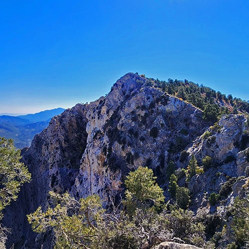
Arrival on the Wilson Ridgeline: Observation Plateau!
At the point the approach ridge meets the Wilson Ridgeline, there’s a nice little plateau viewpoint with a spectacular 360-degree view. Rocky Gap Road winds through the canyon directly below. The Rainbow Mountains Upper Crest Ridgeline stretches along the East (far) side of the canyon from White Rock Mountain all the way to Potosi Mountain. Further East is Red Rock Canyon, the Las Vegas Valley and Strip, Muddy Mountains, Sunrise Mountain, Frenchman Mountain, Lake Mead and points further East. To the North you can see the entire impressive La Madre Ridgeline forming a huge crescent shape. Beyond that ridgeline are the Sheep Range and points in the Mt. Charleston Wilderness including Harris Mountain at the summit of the Wilson Ridgeline and Griffith Peak at the summit of the Sexton Ridgeline. Between the two peaks you can see the North Ridgeline of Kyle Canyon. To the West is the entire expanse of Lovell Canyon from the Mt. Charleston Wilderness to Potosi Mountain. The Panamint Range on the West side of Death Valley with Telescope Peak and Wildrose Peak are visible. There’s far more in all directions, but too much to list here!
Where to from This Wilson Ridge Observation Point?
On this day I headed back down the approach ridge to Lovell Canyon. But on another, more streamlined adventure up the approach ridge, with more daylight than this mid-October day, there are some good possibilities to the North and South along the Wilson Ridgeline.
To the South on the Wilson Ridgeline
To the South is the North Twin Pinnacle, looking fairly easy to ascend. The saddle between the North and South twin pinnacles (Mini-Matterhorns) may be a bit challenging with a steep limestone slab to traverse. If the traverse is possible two natural loops would open up: One loop down the second approach ridge North of Rocky Gap Road. A second loop, a bit longer, would take the Wilson Ridgeline South to Red Rock Summit, then descend the ridgeline running parallel and above Rocky Gap Road down to the intersection of Rocky Gap Road and Lovell Canyon Road.
To the North on the Wilson Ridgeline
To the North of today’s observation point on the Wilson Ridgeline, there is a steep plunge to a lower, long saddle on the ridgeline. At the base of this saddle one could loop downward to the West back to Lovell Canyon Road. Potentially, one could descend to the East to Rocky Gap Road and Red Rock Canyon. Or, you could take the steep ascent North on the Wilson Ridgeline beyond the saddle to the next high point where you would have the choice of continuing North on the Wilson Ridgeline toward Harris Mountain or splitting off to the East along the La Madre Ridgeline. The Northward route looks pretty challenging. However, sometimes the challenges tend to melt away as you proceed along these routes.
These Ridgelines are Spectacular!
Either way, as long as you’re on one of these great ridgelines, it’s like being on the mountaintop with spectacular 360-degree views the entire way!