White Rock Mountain Loop Overview
The Ultimate Training Trail for Strength and Agility on the White Rock Mountain Loop Trail
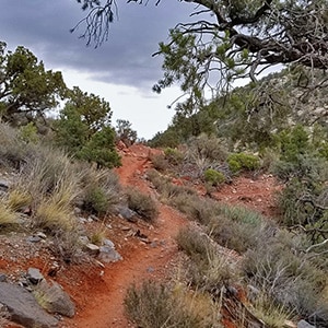
White Rock Mountain Loop Trail in Red Rock Canyon National Conservation Area, Nevada is the ultimate trail for training and for a brief immersion in a rugged desert environment without spending too much time getting there. The surface is for the most part fairly smooth making it a great trail for trail running. There are sections with lots of twists and turns which build agility and create the feeling of driving down a curvy road in a fine sports car. There are places around the Willow Springs area where you’re wading through a rocky surface, but this only adds to building stability and flexibility on the trail. Fairly gradual but substantial ascents build strength. And you can easily double the 6.5 mile loop for a 13 mile half marathon, or run it 4 times for a full marathon!
The views along the White Rock Mountain Loop Trail are amazing including Turtlehead Peak, the Calico Hills, Blue Diamond Mountain, Mt. Wilson, Juniper Peak, Rainbow Mountain and Bridge Mountain.
A Great Training Trail to Break in New Trail Gear on the White Rock Mountain Loop Trail
If you have a new pair of running shoes or boots, or new wilderness gear, this is the trail to test it out. With a good trailhead at 2 different points fairly equally distanced (Willow Springs Trailhead and White Rock Mountain Trailhead) there are facilities to stop and refresh about every 3 miles.
Easily Extend to a Half Marathon or Full Marathon on the White Rock Mountain Loop Trail
You can easily extend your adventure by taking a 1.5 mile deviation on the Keystone Thrust Trail to view the base of that majestic cliff system at the back of Red Rock Park. Or, take another deviation up to La Madre Springs to view beautiful waterfalls that run year-round. Continue up to Miner’s Cabin and then for a legendary adventure continue on to the top of the Keystone Thrust for the most incredible views of Red Rock Park, Calico Basin, the Mt. Charleston Wilderness, the Las Vegas Strip and points all around the greater Las Vegas Valley. Or just take a brief half mile deviation a few hundred yards from the trailhead to White Rock Springs. In addition, you can practice some basic bouldering skills and go for White Rock Mountain summit.
In all, this is a nearly perfect training ground and departure point for wilderness adventures.
White Rock Mountain Loop Trailhead Directions
2 Main Access Points for the White Rock Mountain Loop Trail
There are 2 access points to White Rock Mountain Loop Trail. The main access point is the White Rock Mountain turnoff from the main Red Rock Park scenic loop road. This is the next turnoff after the Scenic Loop High Point–on the right. It’s well marked. There is a lower and an upper parking area separated by about a half mile of unpaved road which is pretty well graded. The second access is the following turnoff – Willow Springs – and you can access the loop at one of 2 parking areas on that turnoff.
2-Car Option for a Half-Loop Trip on the White Rock Mountain Loop Trail
If you have 2 cars and want to do only half of the loop park one at the White Rock Mountain turnoff and the other at one of the Willow Springs parking areas. Start from Willow Springs, end at the White Rock Mountain turnoff and then drive back along the Red Rock Park Scenic Drive to Willow Springs to pick up the other car. You need to do this in that order due to the fact the Red Rock Park Scenic Drive is a one way loop drive.
White Rock Mountain Loop Adventure Description
Clockwise or Counterclockwise Direction on the White Rock Mountain Loop Trail?
From the White Rock Mountain Loop trailhead in Red Rock Park, you have the choice of 2 directions: Clockwise or counterclockwise. If you’re making multiple trips around the loop, reversing your direction each time at this point will give you the sensation of traveling over 13 miles of different terrain.
Counterclockwise Choice for White Rock Mountain Loop Trail
For this particular trip pictured in the video on this page I made one pass around the White Rock Mountain Loop in the counterclockwise direction. I parked at the lower White Rock Mountain parking area and ran up the half mile unpaved road to the main trailhead due to the fact that I don’t like to drive my car off asphalt pavement. However, the half mile unpaved road between the two trailheads is very good and should not require a 4WD vehicle.
Deviation Option from the White Rock Mountain Loop Trail to the Keystone Thrust Trail
Shortly after embarking from the upper main trailhead onto the White Rock Mountain Loop, you’ll descend into and cross a wash. Don’t follow the temptation to travel up the wash as that will take you off trail. Cross the wash and at that point you’re faced with a spilt. To the right you could take the off-loop 1.5 mile deviation on the Keystone Thrust Trail to view the base of the majestic Keystone Thrust at the back of Red Rock National Park. On the other hand, the left split is the continuation of the White Rock Mountain Loop trail.
Ascent to the High Point on the White Rock Mountain Loop Trail
This begins a gradual but rather healthy ascent to the high point before looping around the back side of White Rock Mountain. Ascending to and descending from this high point you’ll be on a smooth curvy trail that will make you feel like a sports car speeding on a curvy mountain road. This is great fun whether you’re walking or running. As you rise to the top of the ascent turn around often to see Red Rock Canyon opening up behind you with great views of Turtlehead Peak, the Calico Hills, Blue Diamond Mountain, Mt. Wilson, Juniper Peak, Rainbow Mountain and Bridge Mountain.
Descending from the High Point on the White Rock Mountain Loop Trail
At the summit of the ascent look down to see the Keystone Thrust stretching to your left and right, and the canyon between White Rock Mountain and the Keystone Thrust to your left which is the direction you will be heading around the loop. The plant life along the trail becomes more diverse with pine and juniper and a host of desert shrubbery (you can tell I’m not a botanist). The rock becomes a beautiful mixture of red and white (I’m also not a geologist) which adds to the overall majestic beauty of the area. This portion of the trail can be very fast and a way to increase agility with all the twists and turns. Along the way you reach a point where you can look up and see the saddle of White Rock Mountain with the summit to your right. I believe this would be a great point to ascend the mountain–heading off the loop trail at the base of the saddle to the summit of the saddle, then taking a right to the summit of White Rock Mountain. It looks easy enough. However, I’m not sure about the final brief section up the head wall immediately below the summit. This may or may not require a bit of more serious rock climbing.
Intersection of the White Rock Mountain Loop Trail and the La Madre Springs Trail
The White Rock Mountain Loop trail eventually meets up with the main trail that heads to La Madre Mountain Springs to the right, or continues around White Rock Mountain Loop to the left. At this point the surface, though wider, becomes rocky and a bit more technical for running, but no problem for walking. You’ll soon reach the intersection of Rocky Gap Road. Take a left on Rocky Gap Road and head down along the edge of White Rock Mountain to the Willow Springs parking and picnic area.
Short Deviation to View Petroglyphs in the Willow Springs Area
I took a deviation at the intersection of Rocky Gap Road and headed down a wash to travel along the base of the ridge to the right as I headed down toward Willow Springs. This was slow going, but eventually brought me to the location of the petroglyphs along those cliffs (pictured in the slide show on this page). At this point due to the rain mixed with snow and the cold, my camera mysteriously stopped saving the videos I was recording! I’ll return to recapture these and the videos for the remainder of the loop. At the petroglyphs, I took the brief jog back to Rocky Gap Road and down to the Willow Springs parking and picnic area.
Reconnecting with the White Rock Mountain Loop Trail at the Willow Springs Picnic Area
The continuation of the White Rock Mountain Loop is at the lower end of the picnic area. You’ll begin circling around the Red Rock Canyon side of the White Rock Mountain. On a clear day you’ll not only see awesome views of the canyon stretching below, but beautiful views of White Rock Mountain. On this particular day I was pretty much socked in with clouds, rain, ice, snow and wind and a camera that had stopped recording videos! I’ll return to catch a better view of this area.
Continuing Along White Rock Mountain Back to the Main White Rock Mountain Loop Trailhead
Continue along the front side of White Rock Mountain, mostly ascending back to the main White Rock Mountain Loop trailhead. To your right you’ll often see portions of the Red Rock Park Scenic Drive immediately below. You’re traveling now between the scenic drive and White Rock Mountain. Just a couple hundred yards from the end of the loop there is a half-mile turnoff trail to the left which will take you to White Rock Mountain Springs. On this trip I passed that up as the thought of more water was not too inviting to this cold, rain, show and ice-soaked runner!


