Overview, Potosi Mountain, Southern Approach, Spring Mountains, Nevada
Potosi Mountain at the Southern Tip of the Spring Mountains Just South of the Rainbow Mountains
Technically, Potosi Mountain is not in the Rainbow Mountain Wilderness, but just beyond at the South end of the Spring Mountains. However, I included it here in the Rainbow Mountain Wilderness section because adding that one more menu link as a stand alone made this website menu go nuts!
Potosi Mountain Southern Approach is a Huge Endurance Test
The Southern approach to Potosi Mountain is nothing less than a huge endurance test. Though it’s only 14 miles out and back from my starting point at the “warning rock” parking area, and you’re on a pretty good road all the way to the summit, the angle of incline is the challenge. Think streets of San Francisco, only instead of a one block steep incline you’re looking at half-mile sections of incredibly steep incline. The incline is so steep in places that you’re gaining nearly one foot elevation gain per stride! One note: your total ascent is between 3,500 and 4,000ft.
Potosi Mountain Road Conditions and Wheeled Vehicles
Riding a mountain bike of Potosi Mountain Road would be an experience approaching a suicide mission. You’d better have very very good breaks…in fact check your brakes with any wheeled vehicle before attempting this route.
A good 4WD vehicle can handle Potosi Mountain Road. The steep ascents are paved until you pass the South Summit. In fact, if your 2WD vehicle has a mighty engine, it can probably make it at least to the base of the South Summit. I wouldn’t take a 2WD vehicle beyond that. It does get a little dicey between the South and the North Summit for all vehicles, but not nearly as crazy as the #1 worst unpaved road I have ever experienced, Lucky Strike Road to Angel Peak!
Spectacular Views All the Way Up to and Including Potosi Mountain’s 3 Summits
However, the rate of ascent has a benefit. If you take time to turn around and look back across the landscape every 10 minutes or so, an incredible huge panorama of valley and mountains continues to expand.
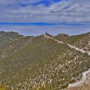
There are 3 summits to Potosi Mountain which I will refer to as the South Summit, Mid Summit and North Summit (the highest as around 8,500ft). From these summits you can see more points of interest than there is space to document here. A few include the entire span of the Spring Mountains up to the Mt. Charleston Wilderness including Charleston Peak and Griffith Peak; the Rainbow Mountain Wilderness, Red Rock Canyon National Conservation Area, La Madre Mountains Wilderness, the Las Vegas Strip, much of the Lake Mead National Recreation Area, the Black Mountains and Mt. Wilsonin Arizona, Telescope Peak and many other points of interest in Nevada, California and Arizona.
No Wilderness Navigation Skills Necessary on Potosi Mountain Road
Navigation is easy. Just stay on the road! There are not even any confusing tributary roads. The main road is obvious. I had hoped to use this easy to navigate route in order to scope out a much more challenging route…the Western approach to Potosi Mountain. However, once on the North Summit it was not clear exactly where the Western approach ridge was from that perspective. Oh well, I’ll need to take a “bottom up” approach to figure out that route.
Potosi Mountain Southern Approach Route Timing
It took me about 5 hours to reach the summit (minus videography and rest and exploration on each of the 3 summits) and about 2 hours and 20 minutes to return. The steep angle of ascent slows this runner to a walk, and the steep angle of descent prohibits a fast run unless you want to trash every joint in your body and burn out every muscle from the waist down. I give my best ascent and descent running and walking form tips in the video on this page.
Trailhead Directions, Potosi Mountain, Southern Approach, Spring Mountains, Nevada
Take I-15 South from Las Vegas to Hwy 161 exit at Jean. Take a right onto Hwy 161/Goodsprings Rd. Just before the town of Goodsprings take a right onto Goodsprings Bypass Road (signed as a gravel truck route). After a couple miles, Goodsprings Bypass Road takes a hard right onto Rainbow Quarry Road (unmarked, but there is no other option). Continue on Rainbow Quarry Road to what I will call the “Warning Rock Parking Area” (a large rock warning about a gate ahead). This is the point where it’s best to have a 4WD vehicle to continue. Hwy 509, Potosi Mountain Road, begins here.
About 2 miles beyond this point there is a gate, often or “most often” locked since Potosi Mountain Road was designed as a maintenance route for the communication towers on the 3 summits. You can park outside the gate and continue on foot up Potosi Mountain Road. Alternately, there is a short but steep and rugged gate bypass road to the left just before the gate. This road does require a 4WD vehicle.
Click the map on this page to enlarge and view the complete route in detail.
Suggestion: Click on the map button near the top of this page to download the .pdf version of the map to your phone in case you loose phone coverage during the adventure. You can expand the map view to read the detail.
Trail Observations, Potosi Mountain, Southern Approach, Spring Mountains, Nevada
From the Warning Rock Parking Area to the Gate
My adventure on this day began on foot on Potosi Mountain Road from the warning rock parking area. From there, the road begins a steady but not too dramatic an ascent toward a huge ridge straight ahead. In fact, at the top of this ridge, a bit to the right, you can make out the communications towers on Potosi Mountain’s South Summit. Remember, steep inclines on Potosi Mountain Road are paved, more gradual incline and decline sections are unpaved, but pretty well graded.
After about 2 miles you will reach a locked gate. There is a 4WD bypass road to the left just before the gate that weaves up a hill and rejoins Potosi Mountain Road is about 100 yards. Not too far beyond the gate the incredibly steep ascent begins and continues for the next 2-3 miles to the top of the ridge you saw from the warning rock parking area.
Take time to turn around and enjoy the rapidly expanding panorama behind you!
Best Technique for Steep Ascent
My best “steep ascent wisdom”:
- Concentrating on your form will pay off big in terms of energy conservation.
- Take short steps.
- Lift your advancing leg high, lean forward slightly and let it fall into the next higher step.
- Do not push with the leg that is behind. That would require much more energy. Simply lift that leg.
Road to the Potosi Mountain South Summit
Once you’ve achieve the initial ridge summit, the road circles around to the right and along the back side of the ridge. You immediately see the South Summit communication towers ahead.
As you approach the base of the South Summit you have a choice:
- Take the right fork and ascend to the South Summit
- Or, continue on the main Potosi Mountain Road and circle around the base of the South Summit.
I ascended to the South Summit. The communications building is immediately below the summit. To ascend the final 100-200ft to the summit, scramble up the hill on the right side of a stairway. You can’t take the stairway because the bottom section is missing leaving a 10-15ft drop! The ascent and view are well worth it! Here you have an amazing view up the Spring Mountain Range to the Mt. Charleston Wilderness. To the East Telescope Peak above Death Valley can be seen. There are additional points of interest in all directions.
Potosi Mountain South Summit to Mid Summit
After ascending the South Summit you have 2 choices:
- Retrace your way back down the road, then continue along Potosi Mountain Road to the Mid and North Summit
- Scramble down the back side of the South Summit to reconnect with Potosi Mountain Road.
I took the first route on this day because it seemed as if there would be a lot of scrambling down the side of the ridge to reconnect with Potosi Mountain Road and I could make better time running back down the South Summit Road, take a right and circle around the base of the South Summit. However, having done this, as I passed the South Summit and looked back to study the ridge from below that route appeared pretty easy and might have saved me 10 minutes or so.
Potosi Mountain Mid Summit
The Mid Summit is a very short deviation from the main Potosi Mountain Road and has its own spectacular view, so this deviation is well worth it. It was so windy on this day that the wind rushing through the communication towers on the Mid Summit roared like a jet engine!
From the Mid Summit you get a great perspective including the Rainbow Mountains, La Madre Mountains Wilderness, Las Vegas Strip, Lake Mead National Recreation Area and beyond.
Potosi Mountain North Summit
The North Summit is Potosi Mountain’s highest point at 8,517ft. From the Mid Summit Potosi Mountain Road briefly dips downward before dramatically rising to the North Summit. There are great views, especially to the West toward Las Vegas and beyond along this route. Also, on very windy days this is one of the less windy stretches until you begin your final ascent to the North Summit.
Once at the North Summit communication building, take a not too difficult scramble route immediately to the left of a large conduit. Avoid hanging on or stepping on the conduit as it is not designed to support human weight. At the base of the conduit there is a warning sign that the radio frequency at the summit exceeds the FCC level safe for humans. So, you probably don’t want to spend a lot of time on the summit.
The view from the North Summit is incredible to the West, North and East. The summit itself with its base of beautiful limestone rock and pine forest is equally incredible and peaceful. There are a number of ridges beyond that one could explore. On this day I was pretty tapped out, so turned around to head back down Potosi Mountain Road to the warning rock parking area.
Running and Walking Technique on a Steep Descent
That steep ascent on the approach becomes a steep descent on the return trip.
My best Steep Descent Wisdom
- Take it slow. You may feel you can make a land speed record. However, by the time you reach the bottom rigor mortis will have set in on every muscle in your legs and lower back. You won’t be able to walk comfortably for a week or more.
- Take short steps. Imagine yourself rolling a cube. With every roll the next side of the cube slams down onto the ground. Add a few sides. Less slamming. Add infinite sides to make it a wheel…no slamming at all. Long strides downhill is equivalent to rolling the cube. Lots of slamming. Many short strides approaches the smoothness of a wheel. Less slamming = less damage to muscles and joints, and you live to walk or run another day.
- Wear knee braces. I use neoprene braces with a hole for the knee cap. These provide added stability and, more importantly, act as shock absorbers.
All that said, even moving slowly, my return trip took less than half the time of the approach. Downhill took much less effort and was peaceful, allowing me to really appreciate the view.
Potosi Mountain Southern Approach Summary
What a test of endurance with an incredible view all the way at every moment!