Overview | Turtlehead Peak, Red Rock Canyon National Conservation Area, Nevada
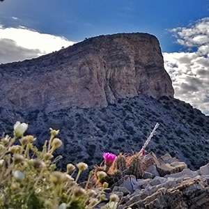
The short 5-mile Turtlehead Peak round trip delivers a lot of value! You’ll traverse hige Mojave Desert terrain, pass an ancient pre-Columbian roasting pit and ascend a steep incline with continually expanding views of Red Rock Canyon. At the summit, a spectacular view of the Las Vegas Valley and points beyond pops into view to the East. There are amazing views of the Calico and Brownstone Basins below to the East with the impressive Damsel Peak just beyond. To the North you can see the high rugged cliffs of the La Madre Ridgeline. To the West are some of the most spectacular view of the colorful Rainbow Mountains. To the South is Blue Diamond Hill. Almost immediately below you can clearly make out your vehicle parked at the Sandstone Quarry trailhead area.
As if all this were not enough, you are in a beautiful ancient limestone terrain dotted by bonsai-like Pinyon Pines, Junipers and Yucca plants. It’s almost too much to take in, especially on your first trip. But expect a challenging hike in ordere to experience all this beauty!
Difficulty Factor
The hike takes about 4 hours, allowing for some time to enjoy the summit. In terms of difficulty, it’s a cross between a hike and a climb with some brief boulder sections and a lot of scrambling on loose gravel. Be prepared to slip on the gravel and fall once or twice along the way, especially on the return trip down hill. Look for the micro-holds, which are the tips of securely anchored rocks poking up in the trail. Try to avoid stepping on any gravel section that is on slanted ground!
The trail can appear and disappear, but continue on up to the saddle (the dip to the left of Turtlehead Peak). Pretty much all trails lead to the top, so it’s hard to get lost. You can see Turtlehead Peak nearly the entire way. The main approach trail ascends the left side of the canyon immediately to the North (left) of Turtlehead Peak. Along the way you may end up having to scurry up or down an especially steep gravel section if you loose the main trail, marked in places with a green trail marking.
Best Time of Year to Hike Turtlehead Peak
The best time to hike Turtlehead Peak is in the Fall, Winter or Spring, or as early as possible on a Summer morning to avoid high temperatures after 10am. Bring at least 2 liters of water.
Directions to the Start Point | Turtlehead Peak, Red Rock Canyon National Conservation Area, Nevada
From I-215 in Summerlin at the Red Rock Casino, take Hwy 159 (Blue Diamond Road) West toward the mountains. Red Rock Canyon Scenic Drive is the 2nd turnoff to the right, about 4 miles after leaving Summerlin. You will need a reservation to enter the area and gain access to the scenic drive. Once on the Red Rock Canyon Scenic Drive, the Sandstone Quarry trailhead parking area is the 3rd parking area beyond the Red Rock Canyon Scenic Drive.
Turtlehead Peak is one of the most popular hikes in Red Rock Canyon. For this reason, if you don’t get to the trailhead at the Sandstone Quarry parking area by 7am on a Saturday or Sunday, you may risk having to park along the Red Rock Canyon Scenic Drive and walk 1/4th mile or more to get to the trailhead. In fact, in recent years parking along the Red Rock Canyon Scenic Drive is no longer permitted, so you’ll totally miss the Turtlehead Peak or Calico Tanks hike unless you get to the parking area early enough to find a spot!
↓ Narrative Guide ↓
Narrative Guide | Turtlehead Peak, Red Rock Canyon National Conservation Area, Nevada
Turtlehead Peak Trailhead to the Ancient Roasting Pit
The Turtlehead Peak Trail begins at the upper end of the Sandstone Quarry parking area. It’s a good trail and fairly easy to follow…in the beginning. You can see the impressive Turtlehead Peak most of the entire way along the trail.
About 500ft in take a moment to explore the Sandstone Quarry area. Here, huge sandstone blocks were mined in the early 1900s until they became too expensive to transport. There are interpretive displays. See the huge cut sandstone blocks and the place they were mined.
Continue beyond the Sandstone Quarry area. You’ll immediately cross a main wash. Soon thereafter, notice what looks like a large mound of gravel on your left. Don’t miss the significance of this mound! It’s an ancient pre-columbian roasting pit…predating around 11,000 years into the past! It’s likely the oldest human structure you will ever see…by far! I passed this many times before someone pointed out its significance!
Ancient Roasting Pit to the Gateway
Now continue along the Turtlehead Peak Trail. Though you won’t continue up the wash you just crossed, if you did you’d end up at the base of the La Madre Ridgeline cliffs to the North. Today, you’ll cross the wash and pass the well-marked Calico Tanks Trail split on your right as the Turtlehead Peak Trail ascends a low ridge, then descends to again to cross the main wash.
After winding around through a few brief sections of the main wash, the Turtlehead Peak Trail ascends and follows a low ridge to the right and begins to head toward Turtlehead Peak. You’ll pass through a calico opening, like a wilderness gateway perfectly framing Turtlehead Peak. At this point, the incline begins to increase.
Gateway to the Upper Saddle
Now you’re ascending the left side of the canyon just North of Turtlehead Peak as the incline sharply increases. There are a few plateaus along the way with spectacular views of Red Rock Canyon and the Rainbow Mountains behind and to the West. Don’t miss these views.
The steepest ascent begins following the last plateau view area. The trail along this final stretch to the upper saddle to the left and below Turtlehead Peak can become a bit sketchy in places. The incline is steep and the surface has a lot of loose gravel. Watch for microholds, which are the small ends of rocks anchored in the ground, peaking just above the surface of the trail. The ascent can be challenging, but never exceeds a class 2 level walk with a few low rocky ledges to pull yourself over along the way.
Saddle to the Summit
Once at the saddle below and to the left (North) of Turtlehead Peak, things level off a bit. Turn to the right, cross the saddle, then head up toward the peak. You’re now on the final summit approach. The main trail along the final summit approach has quite a steep loose rock surface in places. I find that the most firm footholds are in the pathless area just above the edge of the cliffs to your right. You never need to get close enough to the edge of the cliffs to expose yourself to a fall. Give the cliff edge a good 6-foot margin! And, don’t take this route in the dark. Stick to the main trail much further from the cliff edge if it’s before sunrise and after sunset.
You’ll know when you reach the summit…you can’t ascend any further! This is where the views describes above are all around. Enjoy!
Return to the Trailhead
Be careful on the return trip as you retrace your way back down the steep loose rock slopes. If you’d forgotten, you’ll relearn how gravity works against your stability on downhill slopes! Place every foothold carefully. Curiously, I’ve found that humming or singing a familiar song actually puts your mind in a better frame…more calm…when you’re traversing terrain where you can see exposure to a slip or fall.
Summary and Conclusion
Have fun! This is a great hike/climb with some of the best vista views of Red Rock Canyon, Calico Basin and the La Madre Mountains Ridgeline Cliffs (Keystone Thrust cliff area) at the upper North end of Red Rock Canyon. I describe all this in the first video along with plans to discover a Legendary La Madre Mountain Loop hike/running route which will likely be a 10 -18 hour round trip of about 25 miles with a 4000ft elevation gain. At the time of this writing I have a gap of just 3/4th mile and 600ft left before closing the loop. See the La Madre Mt. page for further details, videos and pictures. For now, see the La Madre Ridgeline Grand Crossing for an experience of the upper La Madre Ridgeline cliffs. This is where I first noticed those cliffs and thought, “I’ve got to stand on that cliffline summit!
Alternate High Ridgeline Route
Note some of the videos and adventures to Turtlehead Peak include a spectacular High Ridgeline Approach route along the ridgeline above and to the North of the main approach canyon. This is actually my favorite route as it’s like being on a mountaintop the entire way as opposed to in a canyon. And, there are a number of fun class 3 rock scrambles on the High Ridgeline Approach. The ridgeline is pathless, but the route is pretty obvious: Just stay near the center of the ridge! As mentioned some…if not all…of my Turtlehead Peak videos follow the High Ridgeline Approach. Sorry! But rest assured that most of the videos return by the main trail.