Overview of the La Madre Mountain Northern Approach Route
The La Madre Mountain Northern approach route moves deep into the beautiful La Madre Mountain Wilderness. The plant life undergoes a change from the Joshua Tree forest to pine and juniper trees.
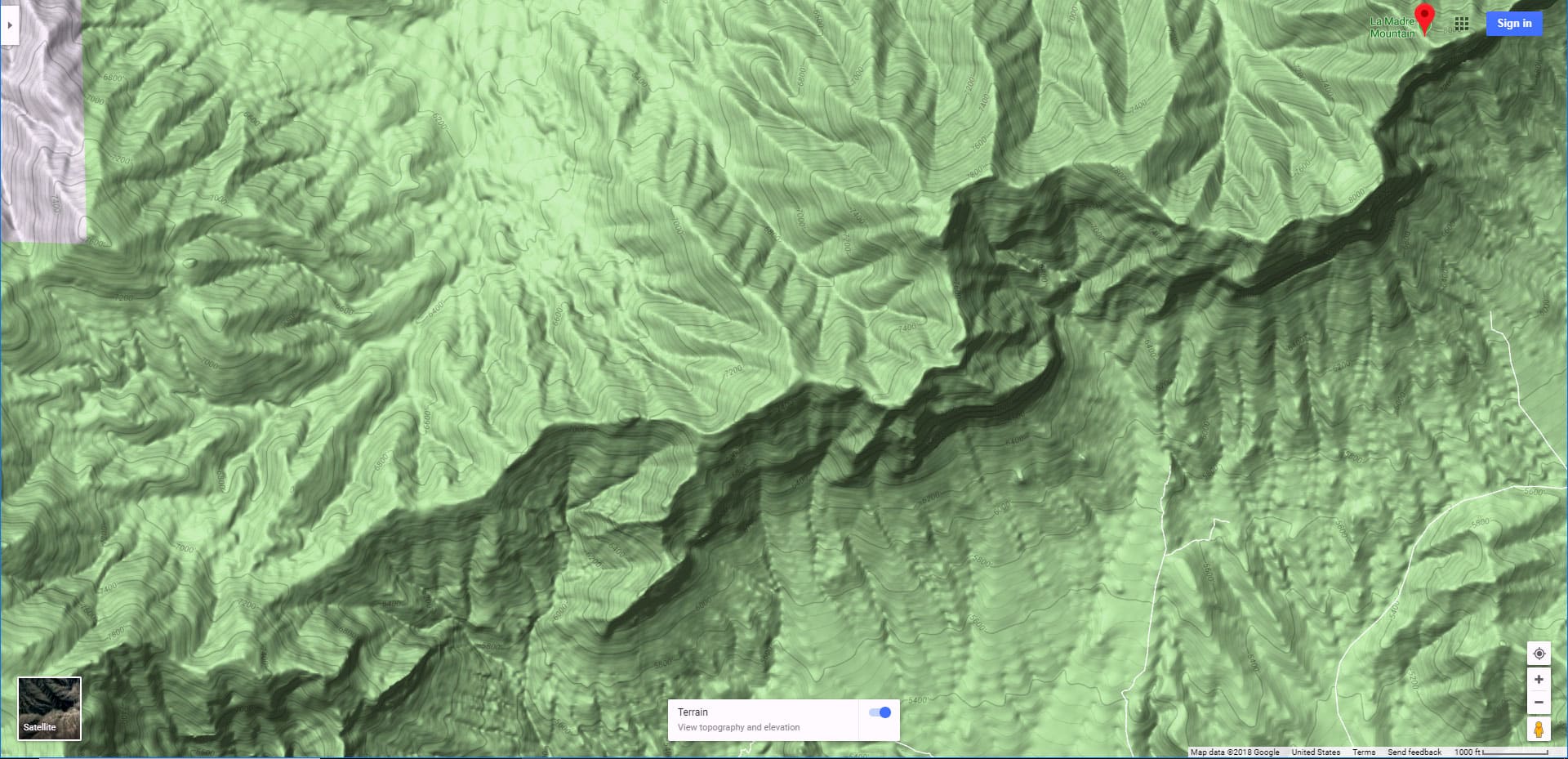
From the La Madre Mountain Summit one can see the entire Las Vegas Valley to the East and beyond to Frenchman Mountain and Lake Mead. To the South one can see Brown Stone Basin, Calico Basin, Damsel Peak, Red Rock Canyon National Conservation Area, Turtlehead Peak, the Rainbow Mountains all the way to Potasi Mountain, the Wilson Ridge system which is the East side of Lovell Canyon, the West side of Lovell Canyon with its upper ridge leading to Griffith Peak summit. To the right of Griffith Peak there is the entire Mt. Charleston Wilderness including Harris Mountain, Griffith Peak, Charleston Peak, Lee Peak, Mummy Mountain, Fletcher Peak and the Mt. Charleston Observatory. More to the North on can see the I-95 Corridor and the desert areas heading toward Reno. To the Northeast one can see the Sheep Range, Fossil Ridge and Gass Peak. Immediately below and to the South is the entire El Padre Mountain summit and stretching out to the right the Keystone Thrust ridge system.
Fourth Exploration (Summit Achieved)
Since the High Elevation Perspective page gives the route up to the point just below the Devil’s Slide, this adventure story will begin at that point. However, a few quick refinements on the lower route: Once you’ve attained the turn-around at the summit of the 4WD road, descend into the canyon to the East, at the bottom of the canyon jog right about 20ft then take a left to rise to the ridge at the opposite side of the canyon. Weave around the bushes–there is ample rock footing on this gentle avalanche slope. Once you have achieved the summit of the ridge take a right. Within about 1/8th mile the ridge will circle around to the left and continue up for a couple miles. During this time weave around from the right to the left side of the ridge and back in order to pick out the best route along the top of the ridge.
Just before the ridge takes a right and heads up to the high point final ridge to La Madre Mountain, skirt to the right to round that corner, then head for the left side of the next ridge. This will be the side least broken up by rocky outcrops. Continue up to the high point final ridge.
Once at the high point final ridge, you’ll take a left to the high point perspective location. At this point the next height you see to your East on the ridge is the summit of Devil’s Slide. Take the upper right side of the ridge to Devil’s Slide summit. Just beyond Devil’s Slide summit you will cross over to the upper left side of the ridge to navigate the rest of the way to La Madre Mountain summit. You’re on avalanche slope from the summit of the 4WD road pretty much all the way up to La Madre Mountain summit, but the good news is that with care you can avoid any serious exposure or fall danger during the entire route.
Third Exploration (Achieved 1000ft Below the Northern Summit):
Route to the Top of the 4wd Road North of La Madre Mountain
Again, beginning at the intersection of Lower Harris Springs Road and Kyle Canyon Road I ran up Harris Springs Road, then took a left up to the top of the 4wd road that ends about 3000ft below La Madre Mountain summit. Now began the adventure scoping out a route between the top of the 4wd road and La Madre Mountain summit.
False Route the Looks Like It May Lead to El Padre Mountain Summit
At first I headed straight up toward what I believe now may be El Padre Mountain summit, Western neighbor to La Madre Mountain. A motorized dirt bike had slashed a path up that route. I soon realized this was taking me away from La Madre Mountain and retraced my steps back to the top of the 4wd road. Here begins the route toward the summit of La Madre Mountain.
Ascending the Ridge Skirting the North Side of La Madre Mountain
The 4wd road ends on a ridge that looks as if it ascends to the top of El Padre Mountain. At the top of the 4wd road there is a faint trail that angles down to a wash then up the ridge to the left (East) of the 4wd ridge. Take that trail and cross over to the summit of the next ridge to the East. Now angle upward along the top of that ridge which will wind around to about 1000ft below the summit of La Madre Mountain. Navigating the ridge involves weaving around a number of tall rock formations, but with some skillful navigation you can avoid the need to climb any of the rock formations.
Adjoining North-South Ridge Leading Directly to a Hilltop Within 1/4th Mile and a Couple Hundred Feet of La Madre Mountain Summit
At the top of the ridge there is an adjoining ridge that heads directly up La Madre Mountain. On this day I stopped short of ascending this next ridge. However, it looks like you can descend a small saddle then ascend to a hilltop that appears to stand just a couple hundred feet below La Madre Mountain summit and less than 1/4th mile to the West (right) of the summit. Until I reach the tip of this hill I will not know what’s involved getting from that hill to the La Madre Mountain summit and what obstacles lie between.
Overcoming Time and Energy Drain
The major problem to overcome is running out of time and energy below the summit, at which point I have already run over 10 miles from the intersection of lower Harris Springs Road and Kyle Canyon road and am looking at a return trip that will double that distance to over 20 miles total. However, by starting out about 2 hours earlier (at 5am rather than 7am) and not making any route mistakes along the way it’s likely that the next trip will end on the summit of La Madre Mountain.
El Padre Mountain Approach?
As I mentioned, it looks as though the ridge at the top of the 4wd road continues up to the summit of El Padre mountain, neighbor to La Madre Mountain. I’ll scope this out on a future adventure.
Second Exploration (Located the Best Northern Route to the Summit):
Here we find the key to reaching the La Madre Mountain summit from the North via lower Harris Springs Road. The 4-wheel drive road that eventually led to the summit trail is very beautiful, lined with Juniper and Pine trees and in the midst of a wild largely untouched area. There are spectacular views of La Madre Mountain, the Keystone Thrust ridge system upon which it sits, the Mt. Charleston Wilderness and the Sheep Range. On the way I met Steve who has been in the area since 1963, spent a lot of time in the wilderness and was a real wealth of information on place names and history in Mt. Charleston Wilderness, La Madre Wilderness and Red Rock Park. I’ll be seeding some of the valuable information he shared into videos going forward in all these locations.
Overshooting the Turnoff to La Madre Mountain
We traveled further up Harris Springs Road, at first bypassing the 4 Wheel Drive route that would eventually show itself to be the key to the summit. Instead we went further up Harris Springs Road eventually taking a left at Paradise Springs Road only to be stopped by a gate with a sign posting dire warnings of potential loss of life should we proceed.
Locating the Turnoff to La Madre Mountain
So, we turned around and retraced our way back down Paradise Springs Road, then down Harris Springs Road to a promising 4-wheel drive road pointed more directly toward La Madre Mountain. We ascended that road to about 6,500ft where the road ended. However, at the upper end of the 4 wheel drive road there was a faint trail pointing toward the La Madre Mountain summit. I estimate that trail will reach the summit in about 3 miles. Having burned up 4 miles by traveling too far up Harris Springs Road I decided to return in a week or two to go for the summit.
Timing for This Northern Approach Route to La Madre Mountain
Time-wise it looks as though the trip from lower Harris Springs Road to the summit of La Madre Mountain will take between 4 1/2 and 5 hours. The return trip will take about 2 1/2 hours with a total round trip time of about 7 1/2 hours. I ran from the top of the 4 wheel drive road to my point of origin at the intersection of Lower Harris Springs Road and Kyle Canyon Road in just 1 hour and 20 minutes.


