Overview | Eagles Nest Loop | Mt Charleston Wilderness | Spring Mountains, Nevada
The Unique World of Eagle’s Nest Loop
Eagle’s Nest Loop branches off from The Fletcher Canyon Trail less than a quarter mile from that trailhead. However, it’s an entirely different world from the forested Fletcher Canyon Trail. On the 2.7-mile, aptly named Eagle’s Nest Loop, you are in an environment more similar to a high mountain meadow with spectacular views up and down the length of Kyle Canyon and abundant wildflowers in the Spring.
Two Distinct Environments
The trail is very good, altitude gains are fairly gradual and tame and you could divide the loop into two distinct environments: A forested environment on the upper end of the loop and a mountain meadow-like environment on the lower end of the loop. If you want to see the effect of altitude on plant life in the mountains, Eagle’s Nest Loop is a great example.
Great Altitude and Trail Running Conditioning Route
The 2.7-mile Eagle’s Nest Loop makes a great altitude conditioning and trail running route. The altitude, above 7,000ft is a great transition to the higher altitudes in the Spring Mountains and elsewhere. The surface of the trail is very good for taking at a run, but as with all trails, keep an eye out for occasional rough spots. Enjoy!
Spectacular Views Along the Way
Spectacular views along the way include the South rim of Kyle Canyon from The Las Vegas Valley below to The La Madre Mountains, to Harris Mountain, Griffith Peak and all the way to Charleston Peak. Then, at the upper West end of Kyle Canyon catch a glimpse of Lee Peak. On the other, North side, of the loop there is the majestic line of cliffs near the Southern base of Fletcher Peak.
Best Time of Year to Visit Eagle’s Nest Loop
The best time of year to visit Eagle’s Nest Loop is during the Spring or Fall months. Winter could bring some snow, but not necessarily. Summer could bring heat in excess of 100 degrees, and most of the loop is exposed with no shade from the sun.
Directions to Start Point | Eagles Nest Loop | Mt Charleston Wilderness | Spring Mountains, Nevada
Begin at The Fletcher Canyon Trailhead. Driving to the Fletcher Canyon Trailhead. is pretty easy: Up I-95 North from Las Vegas, take a left at the Kyle Canyon exit, continue about 20 miles up Kyle Canyon Road, pass the traffic circle at The Spring Mountains Visitor Gateway, pass the Deer Creek Road turnoff and Mt Charleston Lodge and then onward for less than a quarter mile to The Fletcher Canyon Trailhead. parking on your left. In all, it’s less than 40 miles from the Las Vegas Strip.
↓ Narrative Guide ↓
Narrative Guide | Eagles Nest Loop | Mt Charleston Wilderness | Spring Mountains, Nevada
Locating The Eagle’s Nest Loop Trailhead
Head up The Fletcher Canyon Trail for less than a quarter mile to the Eagle’s Nest Loop trail sign and intersection. The loop begins and ends at this point. Take a right at the trail sign onto the initial ascent up The Eagle’s Nest Loop Trail. If you take The Eagle’s Nest Loop in a counterclockwise direction, you’ll get most of the ascent out of the way within the first half mile, then it’s mostly downhill the rest of the way.
Initial Ascent and Alternate Routes
As you begin The Eagle’s Nest Loop, you’re ascending through a forested area toward the cliff line near the Southern base of Fletcher Peak. There are a couple unmarked pathways that break off from the loop to head up toward the cliffs. I did not try these. There is also a pathway that appears to head downward to Deer Creek Road. I may test these alternate routes out at some point.
Along the Loop’s High North End
As the loop turns Eastward paralleling the cliff line above, you will soon enter a different environment populated by low brush and Spring flowers. The views expand along the top of the loop, so be sure to look to the cliffs on your left, the South rim of Kyle Canyon and mountains on your right, down the length of Kyle Canyon ahead and up Kyle Canyon all the way to its Western Rim behind.
Winding Downward Along the East End of the Loop
The East end of the Loop zig-zags downward. At points, you can see The Mt. Charleston Lodge and The Spring Mountains Visitor Gateway below at the base of Harris Mountain. Across the canyon and above the Spring Mountains Visitor Gateway, you might notice the line of a trail I believe is The Escarpment Trail. Looking up at Harris Mountain, you can trace the summit approach ridge all the way down to the South Climb trailhead area above Charleston Village.
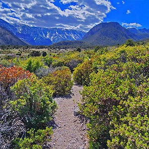
Lower Eagle’s Nest Loop
This, in my opinion, is the best place to take photos of the Spring flowers. And, the spectacular view of upper Kyle Canyon is always directly ahead.
No Alternate Bypass Trails Found
Maps showed a left bypass down to Kyle Canyon Road. I did not find any distinct alternate bypass trails along the lower loop. These may have once existed, but I suspect they’ve been closed off to limit excessive trails in the area. The loop pretty much begins and ends at the Eagle’s Nest Loop trail sign on Fletcher Canyon Trail.