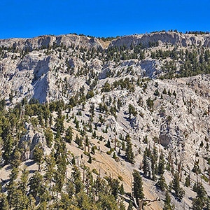
Overview | Mummy Mt Grand Crossing | Foxtail Canyon > Mummy Summit > Deer Creek Road | Spring Mountains, Nevada
Mummy Mt Grand Crossing Route Description
This adventure begins at the
Foxtail Group Picnic Area in
Lee Canyon. From there ascend through the picnic area, an abandoned
Girl Scouts Camp Foxtail and on up to the
Northern Rim of Kyle Canyon. Take a left to connect in about a mile with the main
Mummy Mountain summit route, taken by
many who start at the Trail Canyon Trailhead in Kyle Canyon. Only, in this case you connect with the summit route near the final summit approach to
Mummy Mountain.
After summiting
Mummy Mountain, head down the avalanche slope chute on the opposite side of the mountain,
the Eastern cliffs area. Navigate over to
Mummy Springs and then descend via the
Cougar Ridge Trail to
Deer Creek Road. Take a mountain bike stashed there earlier down
Deer Creek Road to
Lee Canyon Road and finally to your starting point at the
Foxtail Group Picnic Area.
Mummy Mt Grand Crossing Preparation
I recommend a base conditioning level of at least 5-miles running 4 times weekly along with one day topping 10-15 miles. Be altitude conditioned at the 11,000ft level, have wilderness navigation experience and ability to navigate very steep, long avalanche slopes.
In addition, have
summited the Lee/Kyle Canyon summit rim at least once successfully from the Foxtail Picnic Area and
summited Mummy Mountain from that rim. Also, have
descended the Eastern slopes of Mummy Mountain previously and navigated through the wilderness to the Mummy Springs area and on down the
Cougar Ridge Trail to Deer Creek Road. The links in this paragraph will take you to those adventure description pages, videos and pictures. However, once this adventure is completed you will see all the various parts together in one video on this page.
Directions to Start Point | Mummy Mt Grand Crossing | Foxtail Canyon > Mummy Summit > Deer Creek Road | Spring Mountains, Nevada
Take
Hwy 95 North from
Las Vegas. Turn left onto
Lee Canyon Road (Hwy 156). Continue on
Lee Canyon Road about 16-18 miles, passing that road’s intersection with
Deer Creek Road. Continue on
Lee Canyon Road to take turn-around and park in a long parking area on the East (left) side of
Lee Canyon Road just below the entrance to the
Foxtail Canyon Picnic Area. Note: The tables in the picnic area are by reservation only, so, unless you’ve made a reservation do not plan to set up a picnic at one of the tables.
↓ Narrative Guide ↓
Narrative Guide | Mummy Mt Grand Crossing | Foxtail Canyon > Mummy Summit > Deer Creek Road | Spring Mountains, Nevada
I’ve previously worked out every part of this adventure. Today I put all the parts together:
- Lee Canyon Road to Northern Rim of Kyle Canyon: Ascent through the Foxtail Group Picnic Area, Girl Scouts Camp and beyond. (Some trails, mostly wilderness.)
- Northern Rim of Kyle Canyon to Mummy Mountain: (wilderness, no trails)
- Mummy Mountain Final Ascent: (trail, a bit sketchy in places but decent)
- Mummy Mountain Descent: Down the Eastern cliffs (wilderness, no trails)
- Mummy Mountain to Mummy Springs Trail: (wilderness, no trails)
- Mummy Springs Trail to Deer Creek Road: Descend Cougar Ridge Trail, pass through Deer Creek Picnic Area to Deer Creek Road (decent trails)
- Deer Creek Road to Start Point: Mountain biking from Deer Creek Picnic Area to Foxtail Group Picnic Area (the only untried stretch)
Major learnings that will come out in the video:
- Streamlined Ascent to Northern Rim of Kyle Canyon: Smoothed out the approach route from Foxtail Picnic Area to the Northern Rim of Kyle Canyon. The key is staying on the ridge above the Foxtail Canyon wash rather than descending into the wash near its summit. The ridge has a better surface, smoother going, conserves energy which will be needed later.
- The Descent is Challenging: Descending the Eastern cliffs of Mummy Mountain is slow, careful going and takes a lot of time. I’ve done this before, but was again impressed with the difficulty of this stretch. If you lose your hold you could slide a long way to a hard landing!
- Beautiful surroundings: Mummy Mountain is my favorite summit in the Mt. Charleston Wilderness (possible exception Harris Mountain) and always like experiencing it for the first time.
- Temperature differential: The temperature on this day was between 110 and 118 in the Las Vegas Valley depending where you were in the valley. My temperature on Mummy Mountain and throughout this adventure was a comfortable 75-75 degrees!
- Time allotment: The adventure took 12 hours including 2-3 hours for filming and for rest.
- Energy expenditure: I was spent during the final 1/8th mile approach to Mummy Mountain summit. Fortunately, the rest was downhill all the way and I had more energy at the end of the adventure than at the half way point on the summit.
- Test the Individual Stretches Before Attempting the Entire Adventure: Definitely work out all the individual parts of this adventure before attempting the entire circuit in one day. It’s especially important to ascend the Eastern cliffs of Mummy Mountain a couple times and descend at least once before placing that stretch within a larger adventure.
- Mountain Bike was Essential: The mountain bike on the final 5-6 miles on Deer Creek Road and Lee Canyon Road was essential as opposed to walking or running that stretch! It was quite the refreshing experience to sit on a bike and coast downhill at the end of this long adventure. Alternately, if you have two cars, use them!
Overall, this adventure is tremendous fun and pulls together 2 large canyons in the
Mt. Charleston Wilderness and gives a more familiar relationship with the massive spectacular
Mummy Mountain!