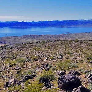
Black Mesa in Lake Mead National Recreation Area has a huge relatively flat summit over a mile in length from North to South and nearly a half mile wide at the mid-point. You could almost fit the Las Vegas Strip from the Luxor Casino to Caesar’s Palace on the summit of Black Mesa. The black rocks from which Black Mesa get’s its name are truly beautiful, reflecting the light of the sun from their desert varnished surface. From small stones to huge boulders they cover the sides and summit of Black Mesa. The summit itself has its own unique plant and animal community, more lush and diverse than the surrounding desert.
From the Southern Summit one can see one of the best views of Lake Mead anywhere. To the West is Frenchman Mountain, to the Northwest is Gass Peak in the distance. And in the far West and Northwest distance one can see the tip of Mt. Wilson at the far side of Red Rock Park, the La Madre Mountains Wilderness, Mt. Charleston Wilderness and the Sheep Range. To the North one can see the Muddy Mountain Wilderness, Pinto Valley Wilderness, Jimbilnan Wilderness and Virgin Ridge. I’m not so familiar with what’s to the East but believe that Gold Butte and Hualapai Mountains are visible in that direction.
Black Mesa has no real marked and established trailhead. However, the route I took started at a pull-out about mile 10.5 on Northshore Road in Lake Mead National Recreation Area just a few hundred feet before the crossing of the major wash that skirts the West side of Black Mesa.
There are a few ways to get to the top of Black Mesa. From the mile 10.5 pull-out on Northshore Road two ways are to head over to the South side of the Mesa which is the more gradual ascent. On the other hand, the closer route is the North ascent, though it is steeper and requires some boulder navigation especially near the summit. I selected the North ascent on this day. It’s pretty much a study in weaving around boulders, some of which are loose. Watch for secure foot placements which are plentiful if you take your time. I seldom had to put down my hiking poles and use my hands. Just don’t put your full weight on anything that is not bomb-proof secure and you should be okay.
In the video I give a few pointers on ascending an avalanche slope. Basically, try to avoid traversing (moving in a horizontal or diagonal direction to the summit) whenever possible and instead head straight up vertically. Traversing an avalanche slope is harder on the body. Heading straight up, while it seems more difficult, is easier and gives better footing and control. The technique for ascending a snow covered slope is similar. Try to avoid traversing.
Once on the summit I skirted the West side of Black Mesa, enjoying the pretty spectacular views mentioned above and pictured in the slides and video on this page. It’s near impossible to get lost on the summit, but helps to note the exact spot where you ascended so you can descend through the head wall on your way back. There is a summit marker on the South side, and probably a closer approach from Northshore Road on that side–possibly near mile 9.5.
In addition to the summit, one can take a 4-mile largely unmarked route around the base of Black Mesa.


Return often to experience one new adventure each week! From the home page scroll to “Most Recent Adventures“. More about David Smith…
The trail adventures on this website require proper conditioning, preparation and safety precautions. There are many factors beyond our control including weather conditions, unstable ground, loose rocks, insects and snakes, people you may encounter, your own level of physical conditioning, the potential of getting lost just to mention a few. While this site offers guidance, helpful tips, direction and training, the reader assumes full responsibility for whatever may occur during their trail adventure. Have fun and be safe!