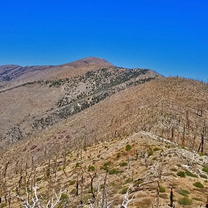
Compared to the traditional popular Griffith Peak ascent from the Mt. Charleston South Climb Trailhead in Kyle Canyon, ascending the Griffith Peak Southern Approach from Lovell Canyon is a much longer adventure with about 2000ft more altitude gain. However, the view is wide open all the way up to Griffith Peak summit and this is a total 1 or 2-day wilderness emersion!
Once I’ve accomplished these 3 routes I’ll have more insight for you. Up to now I’ve scoped them out from the 8,000ft point South of Griffith Peak (video on this page), and have earlier traveled the saddle between Griffith Peak and Harris Mountain.
Take Hwy 160 from Las Vegas toward Pahrump. The highway ascends over a “hump” (the Potosi Mountain area). There’s a saying around here, “Over the hump to Pahrump”. Well, you’ve just traveled over that hump. Around 4-5 miles from the point where the highway begins to descend toward Pahrump there is a well-marked sign on the right for Lovell Canyon Road.
This was one of those adventures where I made a number of wrong turns, but ended up discovering a large part of the Lovell Canyon Western Ridge up to the 8,000ft point. Also discovered navigation strategies for some very different kinds of terrain. Quite the learning experience!
I headed up the Lovell Canyon Trail, then took a left and continued to ascend the Griffith Shadow Loop. I kept to the left, passing the intersection for the Handy Peak Loop. I continued up to the high point of the Griffith Shadow Loop trail…about 7,000ft, just before it circled to the right and began to descend toward Lovell Canyon. The big question: Continue up the ridge beyond the high point or descend the trail in hopes of connecting with a further ridge system? As there was a lot of brush to navigate had I continued up the ridge I descended the trail toward a further ridge that looked more barren. I was also concerned that the upper ridge might not continue unbroken by a canyon.
Mistake! I ended up descending nearly 1,000ft before being able to ascend the ridge that looked more brush free! And the descent and reascent eventually landed me on some rather steep avalanche slopes. You’ll see in the video on this page. On the positive side, I’m even more of an avalanche slope expert than before…and I had a lot of avalanche slope experience! Curiously, there are natural…animal-made trails on the avalanche slopes. The big horn sheep navigate those slopes to feed on the brush, and their trails make navigation a bit easier. Still, it’s pretty rough going!
Once at the 8,000ft high point the view was incredible. I could see across the Wilson Ridge over to the tip of La Madre Mountain, and the tips of Bridge Mountain, North Peak and Mt. Wilson on the border of Red Rock Park. Then down the entire length of Lovell Canyon to Potosi Mountain. Up Lovell Canyon I could see Griffith Peak, Harris Mountain and the saddle between. In addition, I could see other potential approaches from Lovell Canyon to the upper Southern Griffith Peak ridge system.
So, now another choice for the return trip: Head up to the upper ridge and then take that ridge back to the upper Griffith Shadow Loop Trail and then down retrace my earlier route back down to the Lovell Canyon Trailhead, or head down an avalanche slope and canyon to the base of Lovell Canyon. I selected the second choice. Not sure it was the easiest, but definitely interesting.
I headed down a narrow canyon. Not too difficult navigating this first canyon. Lots of beautiful polished rock. It adjoined another canyon heading toward the base of Lovell Canyon. Easier going at first. I had to bypass one dry 15-20ft waterfall. Not too hard. Then I hit a double waterfall: Two 10ft falls. They almost looked possible, but it also looked possible to get down the first 10 feet and be stopped by the second 10ft plunge…and not be able to reascend the first 10 foot plunge…trapped between! And an injury out there in the middle of nowhere could be really bad news.
So, I took a hard right up a very steep and grassy 200ft avalanche slope. Not as dangerous as falling off one of those 10ft dry falls, but definitely a lot longer. At the top of the avalanche slope I knew I’d be able to reconnect with the Griffith Shadow Loop trail and take it down to the wash at the base of Lovell Canyon. It all worked out that way. But all the while that high ridge back at the 8,000ft point was looking more and more like the better, faster, easier choice. Oh well, this was a discovery day. I now know a number of potential approaches up Lovell Canyon to Griffith Peak!


Return often to experience one new adventure each week! From the home page scroll to “Most Recent Adventures“. More about David Smith…
The trail adventures on this website require proper conditioning, preparation and safety precautions. There are many factors beyond our control including weather conditions, unstable ground, loose rocks, insects and snakes, people you may encounter, your own level of physical conditioning, the potential of getting lost just to mention a few. While this site offers guidance, helpful tips, direction and training, the reader assumes full responsibility for whatever may occur during their trail adventure. Have fun and be safe!