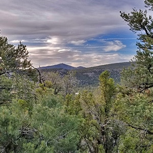
Mud Springs Loop | Lee Canyon Area | Spring Mts, Nevada Fun Wilderness Navigational Puzzle! Mud Springs Loop | Lee Canyon Area | Spring Mts, Nevada Sawmill Trailhead: Trail Will Cross Low Point in Ridge (Background) Mud Springs Loop | Lee Canyon Area | Spring Mts, Nevada First Trail Split: Though Trail is Primarily Green, Follow Red Here (left). Mud Springs Loop | Lee Canyon Area | Spring Mts, Nevada Loop Clockwise Entrance on Ridge. Bypass This for Counterclockwise Loop. Mud Springs Loop | Lee Canyon Area | Spring Mts, Nevada Look Back to Mummy's Head (right): Guide Back to Trailhead if You're Lost Mud Springs Loop | Lee Canyon Area | Spring Mts, Nevada Sisters, Macks and Bonanza Peaks Line Left (SW) Side of Loop Mud Springs Loop | Lee Canyon Area | Spring Mts, Nevada Hwy 95 Corridor Valley & Sheep Range are to the Right (NE) Side of Loop Mud Springs Loop | Lee Canyon Area | Spring Mts, Nevada Take Next Left onto Counterclockwise Loop Entrance Mud Springs Loop | Lee Canyon Area | Spring Mts, Nevada Now Heading Toward Hwy 95 Valley Corridor (Ahead Far Distance) Mud Springs Loop | Lee Canyon Area | Spring Mts, Nevada Left (Green) into Gully for Mud Springs Loop; Right (Red) for Pine Tree Loop Mud Springs Loop | Lee Canyon Area | Spring Mts, Nevada Right in Gully Below Continues on Green Mud Springs Loop Trail. GPS Goes Dark. Mud Springs Loop | Lee Canyon Area | Spring Mts, Nevada Mile 2.6; No Signs for Next 8 Miles; No GPS for 5 Miles Mud Springs Loop | Lee Canyon Area | Spring Mts, Nevada Mummy's Head, Sisters, Macks Peak Across Loop; Reference When Visible. Mud Springs Loop | Lee Canyon Area | Spring Mts, Nevada Enter Mud Springs Spur Rd on Far End (NW Edge) of Loop. Brief GPS. Mud Springs Loop | Lee Canyon Area | Spring Mts, Nevada After Steep Ascent, Road Narrows to Trail Entering Ponderosa Pine Zone Mud Springs Loop | Lee Canyon Area | Spring Mts, Nevada Road Soon Ends at Fence. Pass Through, Then Watch for Yellow Ribbon Guides. Mud Springs Loop | Lee Canyon Area | Spring Mts, Nevada Yellow Ribbons Are Sole Guide Here Until Trail Reappears Mud Springs Loop | Lee Canyon Area | Spring Mts, Nevada Near 9-Mile Point Trail Becomes Distinct, Easy to Follow Mud Springs Loop | Lee Canyon Area | Spring Mts, Nevada First Sign in About 10 Miles! Right Turn for Mack's Canyon Rd.; Left Continues Loop Mud Springs Loop | Lee Canyon Area | Spring Mts, Nevada Departed Loop, Thought I Was Off Course. Crossed Ridges Toward Mummy's Head Fun Wilderness Navigational Puzzle | Mud Springs Loop Counterclockwise | Lee Canyon | Mt. Charleston Wilderness, Nevada Sawmill Trailhead: Trail Will Cross Low Point in Ridge (Right Background) | Mud Springs Loop Counterclockwise | Lee Canyon | Mt. Charleston Wilderness, Nevada First Trail Split: Though Trail is Primarily Green, Follow Red Here. | Mud Springs Loop Counterclockwise | Lee Canyon | Mt. Charleston Wilderness, Nevada Loop Clockwise Entrance at Low Point in Ridge. Bypass This for Counterclockwise Loop. | Mud Springs Loop Counterclockwise | Lee Canyon | Mt. Charleston Wilderness, Nevada Look Back to Mummy's Head (right): Always Guide Back to Trailhead if You're Lost | Mud Springs Loop Counterclockwise | Lee Canyon | Mt. Charleston Wilderness, Nevada Sisters & Macks Peak Line Left (SW) Side of Loop | Mud Springs Loop Counterclockwise | Lee Canyon | Mt. Charleston Wilderness, Nevada Hwy 95 Corridor Valley & Sheep Range Line Right (NE) Side of Loop | Mud Springs Loop Counterclockwise | Lee Canyon | Mt. Charleston Wilderness, Nevada Take Left Here onto Counterclockwise Loop Direction | Mud Springs Loop Counterclockwise | Lee Canyon | Mt. Charleston Wilderness, Nevada Heading Toward Hwy 95 Valley Corridor (Ahead in Distance) | Mud Springs Loop Counterclockwise | Lee Canyon | Mt. Charleston Wilderness, Nevada Left (Green) Here for Mud Springs Loop; Right (Red) for Pine Tree Loop | Mud Springs Loop Counterclockwise | Lee Canyon | Mt. Charleston Wilderness, Nevada Right in Gully Continues on Green Mud Springs Loop Trail. GPS Goes Dark Here. | Mud Springs Loop Counterclockwise | Lee Canyon | Mt. Charleston Wilderness, Nevada Last Trail Sign at About Mile 2.6; No Signs for 8 Miles; No GPS for 5 Miles | Mud Springs Loop Counterclockwise | Lee Canyon | Mt. Charleston Wilderness, Nevada SW Side of Loop Bordered by Mummy's Head, Sisters and Macks Peak Reference Markers When Visible. | Mud Springs Loop Counterclockwise | Lee Canyon | Mt. Charleston Wilderness, Nevada Enter Mud Springs Spur Rd on Far Side (NW Edge) of Loop | Mud Springs Loop Counterclockwise | Lee Canyon | Mt. Charleston Wilderness, Nevada Road Narrows to Trail Entering Ponderosa Pine Zone | Mud Springs Loop Counterclockwise | Lee Canyon | Mt. Charleston Wilderness, Nevada Road Soon Ends at This Fence. Pass Through, Then Watch for Yellow Ribbon Guides. | Mud Springs Loop Counterclockwise | Lee Canyon | Mt. Charleston Wilderness, Nevada Near 10-Mile Point Trail Becomes Distinct, Easy to Follow | Mud Springs Loop Counterclockwise | Lee Canyon | Mt. Charleston Wilderness, Nevada First Sign in About 10 Miles! Right Turn for Mack's Canyon Rd.; Left Continues on Loop | Mud Springs Loop Counterclockwise | Lee Canyon | Mt. Charleston Wilderness, Nevada I Left Loop Gully Stretch, Thought I Was Off Course. Ascended Ridge, Headed Toward Mummy's Head | Mud Springs Loop Counterclockwise | Lee Canyon | Mt. Charleston Wilderness, Nevada

Mud Springs Loop | Lee Canyon | Mt. Charleston Wilderness | Spring Mountains, Nevada

Mud Springs Loop Overview

This adventure covers Mud Springs Loop in a counterclockwise direction. The clockwise loop adventure will come in the future. 

Where is Mud Springs Loop and What Can You See?

Mud Springs Loop is accessed from the Sawmill Trailhead on Lee Canyon Road. The loop is about 15 miles long, depending on the variation you end up taking. The variety along the loop is incredible, including beautiful Pinyon Pine, Juniper and Ponderosa Pine forested stretches and high desert yucca and cactus stretches. At various points you’ll emerge from the forest to see spectacular vistas and surrounding reference peaks such as Mummy’s Head, the Sisters, Macks Peak, tip of McFarland Peak, Bonanza Peak and the beautiful desert valley and terrain below to the North and East including a backdrop of the Sheep Range and Gass Peak.

Mud Springs Loop is Fairly Tame

The challenge of Mud Springs Loop is staying on course! There’s no technical difficulty as you can always be on a trail unless you stray off course. And even if you lose the trail and end up having to navigate pathless wilderness, the gullies and ridges are fairly tame.

What is The Challenge of Mud Springs Loop?

The 15-mile length creates an endurance challenge, but there’s an even greater challenge: Staying on course!

Here are some of the factors that complicate the goal of successfully navigating Mud Springs Loop:

  1. The trail is unclear: There are unmarked branching rabbit trails at points and at times the trail totally disappears in the brush.
  2. The trail marking system is confused and often missing: There is a color-coded system for the Sawmill trails including Yellow, Blue, Brown, Red and Green. Mud Springs Loop is meant to be Green. However, to stay on the loop you need to follow a red marker at one point, yellow ribbons at another point and a brown marker at yet another point. And, for about 80% of the trail there are no directional markers, including at important junction points.
  3. Surrounding points of reference are most often hidden: Mummy’s Head is a good reference for returning to the trailhead. Macks Peak and its ridgeline identify the Southern border of the loop. Ridgelines with a backdrop of the desert valley and Sheep Range indicate the Eastern border of the loop. However, about 70% of the time these reference points are hidden by the forest and gullies you are traversing, including at important turning points.
  4. GPS is mostly unreliable: I set markers on my GPS app before hiking the loop, thinking I’d track from marker to marker. That didn’t work because GPS went dark at 2.6 miles, reappeared at about 7.5 miles for a brief half-mile, then went dark again until the last couple miles. Basically, there was no GPS for about 80% of the route.

The result of all the above factors is that Mud Springs Loop became a fun navigational challenge. Most of the time staying on course was a combination of trail finding skills, remembering the last distant reference peak that had been visible, and at the half-way point being reassured by GPS that I was on track.

All the complications aside, as documented in the video, I stayed exactly on track around the loop until the final 2-3 miles when, thinking I was going in the wrong direction (I was actually on course), I left the route, ascended a ridge and headed toward Mummy’s Head. 

Best Time of Year for This Adventure

Stick to later in the Spring or earlier in the Fall. Winter may bring snow; Summer temperatures can rise above 100 degrees. I took the loop the last week of May. Perfect temperature: About 70 degrees the entire way!

Mud Springs Loop Trailhead Directions

Take Hwy 95 North from Las Vegas and take a left at the Lee Canyon Road  exit (Hwy 156). Travel up Lee Canyon Road about 13 miles. Take a right onto the Sawmill Trailhead Access Road and proceed to the trailhead. Stay left to reach the upper trailhead parking area.

Mud Springs Loop Trail Observations

Getting Your Initial Bearings

The most important reference point is easily visible from the trailhead. It’s Mummy’s Head. Where ever you are on the loop, you can always return to the trailhead by ascending a ridge, siting Mummy’s Head and then heading toward the left side of Mummy’s Head, keeping Macks Peak to your right and the Sheep Range to your left. To get to the far side of the loop, go in an opposite direction from Mummy’s Head with Mack’s Peak to your left and the Sheep Range to your right. Though the loop is 15 miles in length, you’re never more than about 6 miles from the trailhead. But wow, if you lose the trail and need to head through the wilderness back toward Mummy’s Head, you’re in for a huge effort of crossing multiple ridgelines and canyons, as you travel against the grain of the terrain!

Sawmill Trailhead to the Counterclockwise Loop Entrance

From the North parking area at the Sawmill Trailhead, enter the trail and continue until you reach the first junction. You’re on the Yellow (Sawmill) loop at first. In about a mile, when you reach the first junction, take a left even though that branch is marked red. On this day there was actually some green tape wrongly directing hikers to the branch to the right, which was wrong!

So, follow the red marker along the left branch as you ascend the distinct ridgeline above to the North. You’ll wind around and up to an opening at the top of the ridgeline. At this opening there is a green trail marker pointing to a left branching trail. If you want to take Mud Springs Loop in a clockwise direction, turn left here. As I was taking Mud Springs Loop in a counterclockwise direction, I continued along the top of the ridgeline past this first green marked junction for another mile to the second green left turn. As you traverse the top of the  ridgeline, you can see the entire Mud Springs Loop area spread out below to the West. 

You need to take the second green left turn. If you miss it, you’ll continue straight onto the blue Pine Tree Loop trail, totally missing Mud Springs Loop.

Counterclockwise (Green) Loop Direction to the Half-Way Point

That second green left turn quickly leads downward into a gully where your GPS may go dark, mine did. Now you’re without GPS until the half-way point at the far end of Mud Springs Loop. There are no trail markers. Occasionally, you’ll ascend ridgelines where you can see Mummy’s Head behind, Macks Peak to the left and the Sheep Range to the right. Fortunately, the trail along this stretch is fairly easy to follow with careful observation, and there are no confusing off-branching trails. There are a few points where the trail crosses a wash that looks more like a trail than the actual trail. Watch carefully for the point across the wash where the actual trail continues. Occasional views are spectacular and the Pinyon Pine and Juniper forest is beautiful. Expect near total solitude as few people traverse Mud Springs Loop…especially the distant parts. Remember, if you get lost or off-track, ascend a ridge, identify Mummy’s Head and head toward the left (North) side of Mummy’s Head.

Eventually, you’ll reach the far side of Mud Springs Loop where you cross a wide, confusing wash to find a small cairn marking the point where you turn left. Again, there are no official trail markers. But fortunately at this point my GPS came back on line for a brief moment to indicate I had successfully arrived at the left turn on the far side of the loop. 

Far Side of the Loop to the Confusing Underbrush Stretch

That left turn in onto an actual road. It’s unpaved, but clearly a road. If you miss the cairn, turn left when you reach the road. The road begins to rapidly ascend. Soon you’ll loose GPS. But continue for about a mile. You’ll enter a spectacular Ponderosa Pine forest, then soon the road will suddenly end in a brushy stretch. Mysteriously, there is quite a substantial metal fence with a gate at the end of the road. This must have once been private property. Pass through the gate and continue along the fence for a hundred feet or so. You’re on a very faint trail which, at some point, crosses the fence. Take your pack off to squeeze between the metal pipe bars of the fence and continue through the brush along the other side of the fence. Notice a series of yellow ribbons tied to tree branches to help guide you was through the brush.

In another couple hundred feet the best, most distinct trail of the day will appear as the yellow ribbons disappear. This trail will lead you all the way around the remainder of the loop and back to the trailhead.

Distinct Trail Along the North Side of Mud Springs Loop

I continued along this good trail for about 3 miles. After about 2 miles I actually came across a green trail marker–the first trail marker since the beginning of the loop! Had I turned right at that marker I would have been on the shortest path to Lee Canyon Road. However, that was off the loop, so I continued straight for about a half-mile until the trail dipped down and took a left turn into a narrow wash. The wash steadily descended for such a long time, and with no GPS or view of reference points, I began to wonder if I was off-course. In actuality, I was perfectly on course approaching the final few miles of Mud Springs Loop. Soon, a final right turn would have rounded the low points in the intervening ridgelines and brought me back to the loop entrance.

Wilderness Diversion

However, losing a lot of elevation in that blind wash and apparently heading away from where I thought Mummy’s Head should be, I ascended a tall ridge to the right. At the summit of that ridge I could see Mummy’s Head and so redirected my course in that direction. The wilderness route was pretty brutal! It involved crossing several high ridgelines with deep canyons between. Finally, tired of the ridgelines, I headed upward along the top of one of the highest ridgelines to emerge–what a surprise–on the familiar Macks Canyon Road between Lee Canyon Road and Macks Canyon Group Camp.

Macks Canyon Road to Sawmill Trailhead

I knew a left turn on Macks Canyon Road would take me back to Lee Canyon Road in mile or two and a left turn on Lee Canyon Road would take me back to the Sawmill Trailhead in less that a half-mile. It was an easy return to the starting point, and I had only missed the final 3 miles of Mud Springs Loop by straying off course near the end.  

Summary

This adventure documented on the video MOSTLY follows Mud Springs Loop (12 out of 15 miles). There are 2 variations:

  1. Trust the long descending gully and stay on the loop for the final 3 miles back to the trailhead. That’s an easy solution.
  2. Remember that half-way point with the cairn-marked turn onto the road? You can go a little further beyond the cairn before turning left. This will put you on a slightly wider version of Mud Springs Loop that takes you along the base of Macks Peak and its ridgeline before looping back to the Sawmill Trailhead. 

Solution:

Now that I have all but the final 3 miles of the counterclockwise loop, next time I’ll take the loop in a clockwise direction, ascending along the wider route along the base of Macks Peak, descending to the half-way point, then finally looping back to the Sawmill Trailhead. Knowing the route and its variations, GPS and reference viewpoints will not be needed.

All that said, Mud Springs Loop is a fun navigational challenge. You’re never more than about 6 miles from the trailhead and can always ascend a ridgeline to view Mummy’s Head pointing you back to the trailhead. So, this is a great place to practice basic wilderness navigational and trail-finding skills.

But traverse the loop in the Spring or Fall, start at sunrise and have at least 4-5 liters of water/hydration so you have time and resources if you find yourself going off-course and need to work your way through the wilderness back to the starting point.

Summary
Mud Springs Loop | Lee Canyon | Mt Charleston Wilderness | Spring Mountains, Nevada
Article Name
Mud Springs Loop | Lee Canyon | Mt Charleston Wilderness | Spring Mountains, Nevada
Description
Mud Springs Loop is beautiful, though heavily forested. For this reason, the hiker often has no larger point of reference and can get lost in a maze of rabbit trails, and the directional markers are missing when you most need them. All that aside, Mud Springs Loop is a fun wilderness navigational challenge!
Author
Publisher Name
LasVegasAreaTrails.com
Publisher Logo
Translate »