


Arizona Hot Spring is a natural hot spring nestled in a narrow slot canyon about 1/4th mile above the banks of the Colorado River. It’s a popular hang out for many fans of the hot spring who make it a day adventure. There is camping along the banks of the Colorado River where the Fall, Winter and Spring temperatures are ideal for spending the night in a tent, though, you need to hike all camping gear in and out…or perhaps transport your gear via canoe or kayak down the Colorado from a launch area.
The trails are usually well-traveled. The round-trip hike from the trailhead just 4 miles from the Hoover Dam area on the Nevada/Arizona border on Highway 93 is about a 7-mile round trip hike. A loop that takes in 2 canyons makes the trip even more interesting. Add to that a 2-mile out and back trail to Liberty Bell Arch and a grand overlook of the Colorado River Canyon and this adventure rivals any other one-day adventure in the Southwest.
Liberty Bell Arch is a pretty impressive natural arch spanning an open area beneath that actually has taken on the shape of the Liberty Bell. Visible from the Liberty Bell Arch trail are the I-11/Highway 93 bridge at the Hoover Dam area, some towers at Hoover Dam, Fortification Hill, the Muddy Mountains, Mt. Wilson and the huge valley between the Colorado River and the Black Mountains range where Mt. Wilson appears as a central high point.
Signs at the trailhead report that there is no ladder at the hot spring due to the old ladder being washed out in a flood. However, as of January 2021 there was a new ladder installed. It’s a bit scary climbing or descending that vertical 20-30ft ladder, hanging on while the hot spring showers you with warm water. However, there is a rope that helps hold the ladder in place, though it does sway back and forth a bit. As you top the ladder there are loops in the rope you can use to pull yourself up.
For me, the direction I happened to take worked best. Take the White Rock Canyon trail to Liberty Bell Arch Trail. Then take the 2-mile out and back trip up to Liberty Bell Arch. Return to descend White Rock Canyon to the banks of the Colorado River. Traverse the Colorado River to the hot spring canyon. Take the hot spring canyon to the hot spring and beyond to where there is a mountain traverse back to White Rock Canyon and to the trailhead.
Why take the loop in this counterclockwise direction? Two reasons:
There are 2 main trail routes to Arizona Hot Spring: White Rock Canyon and Hot Springs Canyon with a crossover ridge between. These routes can be navigated as a loop making the adventure more interesting. The routes begin at the White Rock Canyon Trailhead. To get to the trailhead:
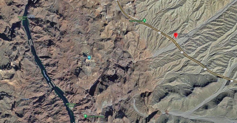
From the trailhead cross under the Highway 93 bridge and head down White Rock Canyon. About 1/8th mile beyond the bridge there is a sign indicating you can continue down White Rock Canyon or take a left toward over the mountains to connect with the Arizona Hot Springs canyon side of the loop.
If you continue down White Rock Canyon you will see the Liberty Bell Arch split-off trail that will take you to Liberty Bell Arch and the grand Colorado River Overlook in just a mile. You’ll travel to a high point where there is a large old mining container still attached to a pully. The trail becomes obscure at this point and you’ll need to keep to the left along the upper ridge of the canyon to your left. The trail will reappear and head down into a canyon, then up the far side to Liberty Bell Arch and the Colorado River overlook. You can actually see Liberty Bell Arch across the canyon from the mining container area overlook, but you’re looking at a side view of the arch so unless you know where it is, you’ll probably not be able to recognize it.
The Liberty Bell Arch trail continues dropping down into the canyon then up the opposite side. There is a small deviation that gives a great picture view of Liberty Bell Arch from the Northeast. Returning to the main trail, continue just past Liberty Bell Arch to find another deviation trail that will take you to right to the base of Liberty Bell Arch.
Return again to the main trail as it continues to ascend and loop around toward the Colorado River overlook. Just as the trail begins to loop there is yet another deviation trail that gives yet another view of Liberty Bell Arch.
Return again to the main trail and ascend to the Colorado River overlook where you can view a long stretch of the Colorado River in both directions winding through the canyon about 1000ft or so below. Realize you’re on the edge of a sheer cliff. The 360 degree view is amazing taking in the Hoover Dam area, Interstate Bridge, Muddy Mountains, Fortification Hill and the Black Mountains Range with Mt. Wilson as a sharp central high point.
Descend the Liberty Bell Arch trail back to White Rock Canyon and take a right down the canyon to the banks of the Colorado River. The canyon walls are a few hundred feet high, formed by the blasting action of raging floods churning huge rocks to a height of 30 feet or more where some can be seen deposited on ledges above. The water and rock action has created a beautiful, smooth-walled passage way with every turn revealing unique and wonderful designs. Looking at the rocks all around and the huge boulders in the canyon, one forming a 50ft cliff, you realize that you don’t want to be in that canyon during a July thunder storm or an earthquake! The floor of the canyon is blanketed by at least 6 inches of fine gravel which requires dumping gravel out of your shoes every now and then.
While there are no difficult ledges or dry waterfalls to descend, do be careful when standing on smooth rock covered with a fine layer of gravel and dust. It can have the stability of standing on ice!
White Rock Canyon continues to wind down to the banks of the Colorado River. Take a left there and watch for a trail that skirts the Colorado River. There are a few signs in key locations that will keep you on course. The sign marked #10 is where you need to make a U-turn up the hot springs canyon to Arizona Hot Springs. I missed the U-turn, which was not clearly marked, and continued straight passing a camping area and restrooms and continuing on until it became obvious I’d missed the hot springs canyon. If you get to the rest rooms you’ve gone too far. So I returned to marker #10 and took that U-turn up the hot springs canyon.
Heading up the hot springs canyon the canyon floor is very fine gravel with about 1-2 inches deep water flowing down from Arizona Hot Spring. In places there are small attractive waterfalls that add to the overall beauty of both sight and sound in the canyon. Don’t work too hard to keep your feet dry, because before you’ve reached the upper end of Arizona Hot Spring you will have been showered with water and have waded through knee deep water. It’s like taking a shower and a bath. Resign yourself to getting completely soaked! Some people wear sandals. However, I would not feel comfortable ascending the shaky 30ft vertical ladder between the lower and upper hot spring with anything but solid trail running shoes.
Then, there’s the 20-30ft ladder. Yes, it’s a bit scary as you ascend this ladder that sways back a forth a bit. But the ladder is pretty secure and there’s a rope you can grasp all the way up. The scariest part is ascending over the top of the vertical ledge. The ladder ends just below the top of the ledge which is very smooth and slick with a steady flow of water. It’s like trying to crawl out of a wet, ceramic bowl. Fortunately, the rope is there, and there are loops to grasp as you continue to pull yourself over the slick wet ledge.
Once at the top, you’re in party land. Many people are soaking in the 100ft or more long, 3ft deep hot spring about the width of a couple large hot tubs (see the slides and video on this page).
When you emerge into the canyon above Arizona Hot Spring, take a few moments to either change clothes or wring your socks out. You’re completely soaked! Continue up the canyon wash.
Tired of traveling in canyon washes I got the smart idea of ascending the hills to the left above the wash in search of a high mountain path way. Bad decision. There were just enough paths that looked like trails to get me completely disoriented. For a time I could neither see a way forward, nor retrace my way back down to the wash. Eventually, by trial and error and logic I did make it back down to the wash. Had this been a Summer day with 120 degree heat getting lost in these hills could have been life threatening. Fortunately it was January and I had lots of water.
Back in the hot springs canyon wash I once again weaved around various twists and turns. The direction is pretty well defined…just stay in the wash. There are even arrows indicating you need to stay in the wash. The canyon wash has a similar beauty to White Rock Canyon, though not quite as majestic. Eventually you’ll arrive at a sign post pointing you to take a left over the ridge between Arizona Hot Spring Canyon and White Rock Canyon. This well-defined ridge traverse trail will take you over the ridge and back into White Rock Canyon just below the highway 93 bridge and the trailhead.
The adventure presents quite a variety from a unique natural bridge to abandoned mining equipment to grand Colorado River overlooks to majestic canyons, to the quiet peaceful banks of the Colorado River to a few class 3 climbing stretches to a canyon with waterfalls to a scary wet 30ft vertical ladder to a hot spring party. You experience all this and much more in the space of about 10 miles! Just try to top this in any other adventure!


