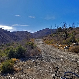
This was a mountain bike off-road cycling adventure beginning at the intersection of Kyle Canyon Road and Lower Harris Springs Road and ending on Harris Mountain Road at about 7000ft elevation for a total elevation gain of 2,800ft.
The important Harris Springs and Harris Mountain Roads system is one of the main access points for the La Madre Mountains Wilderness (4 times the size of Red Rock Park), Harris Mountain and even the Lovell Canyon area and a back door wilderness ascent to Griffith Peak. We take time to show these important wilderness access points. The views from upper Harris Mountain Road are spectacular. One can look straight down the canyon to see the entire Sheep Range, Fossil Ridge and Gass Peak in addition to La Madre Mountain and El Padre Mountain.
About 20% of the road had such deep gravel coupled with a dramatic ascent that it was necessary to walk the mountain bike. My turn-around point came about a mile or less from the Harris Mountain Trailhead. The 2,800ft ascent took about 4.5 hours. The return trip descent took only 1 hr and 10 minutes! Those first few miles descent from the high point on Harris Mountain Road were a bit challenging due to the rough rocky surface and steep incline. One might possibly travel this road in a passenger vehicle. I would not. I highly recommend a high-centered 4WD vehicle.
There are 2 access points to Harris Springs Road, which later becomes Harris Mountain Road. Both are off Kyle Canyon Road: One on lower Kyle Canyon Road, the other higher up near Charleston Village.
The first access is what I call “Lower Harris Springs Road”. It is about 5 miles up Kyle Canyon Road from that road’s intersection with I-95. There is an ample parking area on Kyle Canyon Road (right side) just a few hundred feet beyond its intersection with Harris Springs Road. Take this route if you are heading for the La Madre Mountains Wilderness area and planning to ascend La Madre Mountain and/or El Padre Mountain.
The second access point is what I call “Upper Harris Springs Road”. It is an ample parking area on the left side of Kyle Canyon Road a few miles before the Forest Service Visitor Center near Charleston Village. Take this access point if you are planning on ascending Harris Mountain, entering Lovell Canyon or perhaps shooting for the back door of Griffith Peak. If you do take the upper Harris Springs Road access, note that there are two unpaved roads stemming off from the parking area. Take the main road on the left. This will get you onto Harris Springs Road and Harris Mountain Road. The road to the right leads to an interesting slot canyon which we explored on this page.
During the initial 3 miles on lower Harris Springs Road we document 3 access points to the vast off-road network in the La Madre Mountains Wilderness, which borders Red Rock Park and Calico Basin and is about 4 times the size of Red Rock Park. Two of the access roads reach the hiking/running route to the summit of La Madre Mountain and El Padre Mountain, the high points in the La Madre Mountains Wilderness. It looks as if this road system is a favorite for ATVs and dirt bikes.
Further up Harris Springs Road we document its intersection with upper Harris Springs Road where we take a left and travel about a mile to the intersection with Harris Mountain Road. If you go straight you end up in the town of Harris Springs. A right turn puts you on Harris Mountain Road. We took the right turn. About a half mile up Harris Mountain Road, on the right side of the road, there are a few great camping spots. Harris Mountain Road continues to wind upward above the canyon to the left. As you ascend the beautiful vistas open up behind. There are a few view point turn-outs at key scenic points along the way.
We made it to the 7,000ft point on this first trip. The last 2-3 miles the incline became fairly steep and the road condition more rocky, which slowed us to a walk. I believe the main Harris Mountain Trailhead was only a mile or less up the road from the turn-around point. The Northeastern ridge of Lovell Canyon could be seen a mile or so ahead.
We wanted to document lower Harris Springs Road on this day, which ate up about 2 hours. Next time we’ll begin on upper Harris Springs Road, which should give us enough additional time to make the Harris Mountain Trailhead.


Return often to experience one new adventure each week! From the home page scroll to “Most Recent Adventures“. More about David Smith…
The trail adventures on this website require proper conditioning, preparation and safety precautions. There are many factors beyond our control including weather conditions, unstable ground, loose rocks, insects and snakes, people you may encounter, your own level of physical conditioning, the potential of getting lost just to mention a few. While this site offers guidance, helpful tips, direction and training, the reader assumes full responsibility for whatever may occur during their trail adventure. Have fun and be safe!