Overview | Fire Ecology Trail | Red Rock Canyon National Conservation Area, Nevada
Pine Forest Fire Management Control
The .2-mile
Fire Ecology Interpretive Trail in
Pine Creek Canyon,
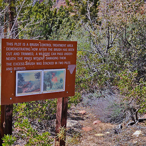
Red Rock Canyon NCA, Nevada, was a controlled burn conducted in 1992 to determine how canyon forests could be managed to protect older trees from being consumed by brush fire. Following a brush management strategy aimed at controlling excess brush fuel on the forest floor, a controlled burn was conducted that successfully passed underneath the
Ponderosa Pines without damaging them.
Interpretive Trail and Picnic Area
Today visitors can walk this interpretive trail, observe the current condition of the 1992 controlled burn, learn from a number of interpretive signs and picnic at a table near the edge of
Pine Creek.
Best Time of Year to Walk The Fire Ecology Trail
The best time of year to hike this trail is mid-Fall through mid-Spring. Summer temperatures can exceed 110 degrees. Learn more by clicking the image or title above.
Directions to the Start Point | Fire Ecology Trail | Red Rock Canyon National Conservation Area, Nevada
From
I-215 take the
Charleston Blvd exit (at
Red Rock Casino) and head upward through
Summerlin toward
Red Rock Canyon National Conservation Area. Take the
Red Rock Canyon scenic drive past the high point overlook and past the
Willow Spring picnic area turnoff. Continue on the
Red Rock Canyon scenic drive past the trailhead for
Ice Box Canyon.
Pine Creek Canyon Trailhead is the next trailhead on your right, a couple miles beyond the
Ice Box Canyon Trailhead.
↓ Narrative Guide ↓
Narrative Guide | Fire Ecology Trail | Red Rock Canyon National Conservation Area, Nevada
Begin at the well-marked
Pine Creek Canyon trailhead sign at the rear of the trailhead parking area. The trail begins with a healthy but brief descent into the canyon below. There’s a split-off trail to the left at the point where the trail reaches the canyon floor. That split leads toward
Juniper Canyon. Don’t take that left split, but continue on the main
Pine Creek Canyon trail. The impressive
Mescalito Pyramid/Peak in the center of
Pine Creek Canyon is a good reference point. Head for that.
In a few hundred feet you’ll come across a well-signed left split for the
Fire Ecology Loop Trail. Take a left onto the short .2 mile loop. The loop has some rather detailed interpretive signs that tell the story of how this area has been used as a test for preserving the majestic
Ponderosa Pines during and following a fire. Pause the slide guide on this page to view some of the interpretive signs.
Along the
Fire Ecology Loop Trail there are picnic areas under the
Ponderosa Pines. Some picnic tables are beautifully located at the edge of
Pine Creek.
There are some additional light trails you can explore in the area:
Enjoy your day in beautiful
Pine Creek Canyon!