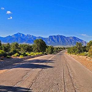
Lovell Canyon Road, the main road spanning the 12-mile stretch from lower -to-mid-Lovell Canyon, is paved and well maintained. Lovell Canyon Road will get you within 1/4th-mile of the canyon’s main trailhead area providing access to:
The above trails provide access to upper Lovell Canyon and the route starting points for the high ridgelines and peaks in upper Lovell Canyon.
The unpaved but well graded Lovell Summit Road will get you from upper Lovell Canyon Road to the trailheads in just 1/4th-mile. If you do not like to take your car off asphalt roads, there is a good-sized parking area at the intersection of upper Lovell Canyon Road and Lovell Summit Road. The 1/4-mile walk up Lovell Summit Road goes fast.
There are many unpaved tributary roads to Lovell Canyon Road. High-centered or 4WD vehicles are recommended. Don’t think of driving Rocky Gap Road without a very good 4WD vehicle or ATV. Landrovers with experienced drivers and ATVs often successfully traverse this route to Red Rock Canyon.
I’ve listed some of the most significant roads in Lovell Canyon and the access they provide in the details below.
There are many great dispersed campsites along all the roads in Lovell Canyon.
Take Hwy 160 from Las Vegas toward Pahrump. The highway ascends over a “hump” (the Potosi Mountain area). There’s a saying around here, “Over the hump to Pahrump”. Well, you’ve just traveled over that hump. Around 4-5 miles from the point where the highway begins to descend toward Pahrump there is a well-marked sign on the right for Lovell Canyon Road.
Lovell Canyon Road is a beautiful stretch passing through a Joshua tree forest that soon becomes populated predominately with junipers and pines. There are ridges and meadows and many camping pull-outs along the way. This stretch reminds me a lot of the high desert area around Bend Oregon. Very open and majestic. All the while you’re looking up at the Spring mountains with Griffith Peak standing prominent. The road has very little traffic and would make a great bike, walking or running route. In fact, what an awesome backdrop for a marathon (pretty easy to add 2 miles to the 24-mile out and back stretch)!
Access 3 main campgrounds:
Access multiple dispersed campsites
Trailhead access to Lovell Canyon’s 4 main upper canyon trails via Lovell Summit Road:
The above trails provide access to the following:
Additional Access:
Trailhead access to Lovell Canyon’s 4 main upper canyon trails:


Return often to experience one new adventure each week! From the home page scroll to “Most Recent Adventures“. More about David Smith…
The trail adventures on this website require proper conditioning, preparation and safety precautions. There are many factors beyond our control including weather conditions, unstable ground, loose rocks, insects and snakes, people you may encounter, your own level of physical conditioning, the potential of getting lost just to mention a few. While this site offers guidance, helpful tips, direction and training, the reader assumes full responsibility for whatever may occur during their trail adventure. Have fun and be safe!