Overview | Landmark Bluff Summit | Lovell Canyon, Nevada
The Huge Summit of Landmark Bluff
If the difference between a mountain and a peak is that a mountain rises at least 1,000ft above its surrounding area, Landmark Bluff, at about 1,200ft above its surrounding base might be classified as a mountain.
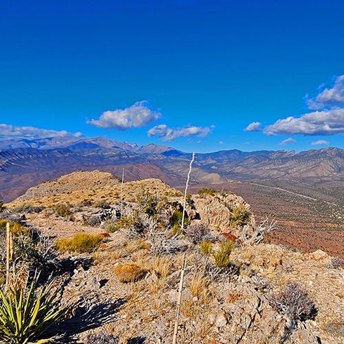
Because of its height over the surrounding area, the 360-degree views from this stand-alone bluff are spectacular.
Landmark Bluff’s summit is huge! It’s about 5 miles in length and, in places, a few hundred feet wide. There’s a lot to explore on the summit of Landmark Bluff.
Most of this adventure is in arid high desert terrain and the typical plants you’ll come across are Joshua Trees, Yucca and Cacti.
Spectacular Views from Landmark Bluff’s Summit
Think about it: You can see Landmark Bluff from the ridgelines on both sides of Lovell Canyon, all the way up to Griffith Peak and Harris Mountain in the Mt. Charleston Wilderness. You can also see the bluff from Potosi Mountain to the South and from the Black Mountains and Panamint Range on both sides of Death Valley. Well, when you’re on the summit of the bluff you can see all these points in an incredible 360-degree view. Here’s a short list:
There’s a lot more to see out there, but I was not able to identify the many additional reference points that I have not yet explored.
Summit Approaches to Landmark Bluff
A complete circuit of Landmark Bluff shows only one summit approach as the pathway to the summit without encountering very steep, loose rock slopes or vertical cliff walls and ledges. The bluff is well protected, offering many difficult ascent options and only one easy ascent option.
If you’re not into steep, loose rock summit approach ridges, Landmark Bluff has some good news and some bad news for you:
- The good news is that there is a gradual summit approach gully that will take you to Landmark Bluff’s summit at a class 2 walk!
- The bad news is that this gully is located at the furthest point from Lovell Canyon’s main road. It’s on the opposite (West) side of Landmark Bluff. If you have a good 4WD vehicle, you can get to the entrance of the summit approach gully via a series of unmarked roads. If you’re on foot, prepare for a long long trek to reach that gully.
Directions to Start Point | Landmark Bluff Summit | Lovell Canyon, Nevada
Take Hwy 160 from Las Vegas toward Pahrump. The highway ascends over a “hump” (the Potosi Mountain area). There’s a saying around here, “Over the hump to Pahrump”. Well, you’ve just traveled over that hump. Around 4-5 miles from the point where the highway begins to descend toward Pahrump there is a well-marked sign on the right for Lovell Canyon Road. As you enter Lovell Canyon, that large bluff to your left is Landmark Bluff.
Head up Lovell Canyon Road for about one mile to its intersection with the unpaved Rainbow Spring Road (537F). There is ample parking at the opening to Rainbow Spring Road.
↓ Narrative Guide ↓
Narrative Guide | Landmark Bluff Summit | Lovell Canyon, Nevada
This is the most streamlined route to the easiest summit approach for Landmark Bluff.
Traversing the Lower East Side of Landmark Bluff
Cross Lovell Canyon Road toward Landmark Bluff. Head down the wash immediately across the road. The wash is surprisingly easy to navigate because there is actually an unpaved road in the wash. Continue down the wash, which parallels Lovell Canyon Road, until you’re only a couple hundred feet from Highway 160 at the entrance of Lovell Canyon. You could descend on Lovell Canyon Road instead, but you might find yourself dodging traffic (the shoulder is pretty narrow, passing RVs are wide) and enduring lots of traffic noise (in particular, dirt bikes). The wash is wider, more secluded and peaceful.
Makeshift, Unregulated Gun Ranges on the South and West Side of Landmark Bluff
Note that there is likely to be active, unregulated target shooting on the South and lower West side of Landmark Bluff, especially on weekends and holidays. On days with active target shooting stick to the roads described below. Avoid becoming a target by straying up-range between the roads and the bluff! There are many target shooting pull-outs and it should be pretty obvious if someone is parked there shooting toward the bluff. The heaviest shooting occurs on the South side of the bluff and at the base of the two canyons furthest South on the West side of the bluff. Once you’re beyond the second Western canyon from the South (Mule Spring Canyon) you’re not likely to encounter target shooting.
Traversing the South Side of Landmark Bluff
Shortly before reaching Highway 160, take a right onto a good powerline maintenance road as you traverse the South side of Landmark Bluff. At the Southwest corner of Landmark Bluff, take a right onto the unmarked road that skirts the West side of Landmark Bluff. Since it’s unmarked and unnamed, I call this the “Westside Road“.
Traversing the West Side of Landmark Bluff to Chute Canyon
Unlike the straight-edge East side of Landmark Bluff, there are a series of 5 canyons along the West side of the bluff. I’ve listed them here from South to North:
- Cave Canyon: Canyon with lots of vertical ledges, some potential steep, loose rock summit approaches and an interesting cave. Roads lead to the cave and to the back of the canyon.
- Mule Spring Canyon: It’s not really named, but contains the Mule Spring oasis with a palm tree, thus, I call it “Mule Spring Canyon“. There are some good potential summit approach opportunities in this canyon. An unmarked unpaved road splits off from Westside Road to enter this canyon. Where the road ends, a trail begins that takes you to Mule Spring.
- Long Ridge Canyon: This is a long, shallow canyon with a gradual summit approach on the South rim that appears to turn evil (steep, loose rock) near the summit.
- Chute Canyon: Best summit approach canyon! This canyon is the narrowest of the 5 canyons. There are high cliff walls on both sides with a long gradual gully (chute) between that will take you to the summit at a totally class 2 walk.
- Northwest Canyon: This canyon is furthest North and contains a lot of vertical ledges on its South side, but some more gradual potential summit approaches on its North side. The Northwest corner has a great potential summit approach ridge. That ridge gets pretty steep with loose rock near the summit, but it looks possible.
Picking Up at the North Rim of Mule Spring Canyon
You’ve been heading North on Westside Road and have just reached the road split at the entrance of Mule Spring Canyon. Take the left split which heads West in order to circle around the base of a huge hill. After about 100 yards, the Western ridges branching off that hill have dwindled and you realize, if you’re on foot, the most direct way to keep heading North is to leave the road, take a sharp right and stick closer to the base of the next shallow canyon I call “Long Ridge Canyon“.
No Good Summit Approach Possibilities in Long Ridge Canyon
That huge hill you just skirted at first looks like a possible summit approach. It’s ridge is gradual, and goes all the way to the summit. However, take a closer look at the terrain just below the summit. The approach ridge turns evil up there with a combination of steep loose rock and some vertical areas with exposure. That final 150 feet could get pretty dicey! Now look at the long indented ridge of the canyon. There’s a cliff band about half-way up the side of the ridge running along its entire length. That band appears to be a 20-30 foot vertical wall. So, Long Ridge Canyon is out in terms of an easy summit ascent route.
Chute Canyon: Best, Easiest Summit Approach Route
The next canyon North is the winner! You know you’ve arrived at its entrance when you reach an unpaved road heading up into the canyon. Take a right onto that road toward the canyon opening. The road will get you pretty far up into the canyon. If you’re driving, note that this road is steep and rocky in places. It’s not graded, but basically two channels for your tires, obviously created only by the prior passage of vehicles.
End of Chute Canyon Road, Final Landmark Bluff Summit Approach Begins
You’ll know when you’ve reached the end of the road. You’re on a hilltop looking up the narrow canyon gully, towering cliff walls on either side. Amazingly, that gully is an easy walk all the way to the summit. Many similar canyons in the Southwest U.S. are blocked by vertical pour-over cliffs, choked by thick brush and huge boulders that would warm a serious rock climber’s heart. On the other hand, this gully has fairly light brush and small rocks. You can easily weave around the brush and rocks, and will even at times come across a pathway. It’s a breeze all the way to the summit!
Note the Location of the Chute’s Upper End!
This summit approach chute is the only way I know to the summit of Landmark Bluff that does not encounter vertical ledges and steep loose rock inclines. And the summit is huge: 5 miles long, up to a few hundred feet wide. There’s a lot to explore up there. As you wander about, you want to know how to return to this one and only easy chute in order to descend back to the base of Landmark Bluff. Fortunately, the upper end of the chute splits, forming a huge arrow pointing to the chute. Make note of that reference point, then explore your heart out on the huge spectacular summit!
Timing and the Return Trip from Landmark Bluff Summit
It took me about 4 hours to reach Landmark Bluff Summit by foot from the intersection of Lovell Canyon Road and Rainbow Spring Road. In fact, I was able to look straight down to that intersection from the summit and see my car (“The Beast”). As the desert raven flies, it was about 60 seconds from the summit.
The return trip was much more rapid. It took just 2 hours and 40 minutes to return to my starting point.
Summary
If you have not yet been to Landmark Bluff Summit, you’re in for a magical day of wilderness immersion. It’s quite the marathon, approximately 16-18 miles in total just to get to the summit and back by this route. If you explore the entire summit, add 10 miles. In fact, imagine making it a 2-day experience and camping on the summit under the stars with unforgettable views in all directions!