↑ Slide Guide ↑ ↑ Slide Guide ↑
General Info + Scenic Drive | Red Rock Canyon National Conservation Area, Nevada

↓ Map Guide ↓
↓ Video Guides ↓
Interpretive Videos Will Be Placed Here
Will include Visitor Center Walk-Through and Scenic Drive Overview
When Scenic Drive Reservations Are Needed, How They Work & How to Get Them
From October 1 to May 31 vehicles must have a Timed Entry Reservation to enter the Red Rock Canyon Scenic Drive.
Hours When Reservations are Needed
- 8:00 AM – 5:00 PM daily
When Reservations are Not Needed
- Before 8:00 AM or after 5:00 PM (October 1 – May 31).
- Between June 1 and September 30.
- The park opens at 6am so you have a 2-hour window where the reservation is waived. However, the entrance fees still apply.
How Reservations Work
- You need to register 30 days in advance (but there is a 2-day rolling reservation option)
- Reservations are $2 non-refundable reservation fee plus park entrance fee.
- Park passes are accepted, but reservation fee still applies. For example, if the park fee is $15.00 and you have a park pass, the $15.00 will be waived, but the $2.00 reservation fee still applies.
To book a reservation
- Go to https://recreation.gov
- Search for “Red Rock Timed Entry”
- Sign up or log in
- Make your reservation
Scenic Drive Overview | Red Rock Canyon National Conservation Area
The 13-mile Red Rock Canyon Scenic Drive provides a rare opportunity to view the major points of interest and sweeping vistas of the entire canyon without leaving the comfort of your car. This is due to the fact that Red Rock Canyon, framed by hills, mountains and cliffs on three sides is viewable in its entirety from nearly every point along the scenic drive. There are nine scenic viewpoints along the drive in addition to the visitor center where you can park and walk just 20-50 feet to view well-designed interpretive displays and additional vistas. The scenic drive affords many photo opportunities with stunning backdrops for memorable portraits.
Directions to the Red Rock Canyon Scenic Drive
To get to the Red Rock Canyon Scenic Drive take Hwy 215 to the Charleston Blvd exit (at Red Rock Casino). At the end of the exit, turn right. You’re now on Hwy 159 (Blue Diamond Road). Had you turned left you would be on Charleston Blvd. The name of the same road changes as it crosses Hwy 215. That can be a bit confusing if this is your first trip here! Once you’ve turned right continue another 5 miles to the Red Rock Canyon main gated entrance where you will take a right into the Red Rock Canyon Scenic Drive area. There is an entrance fee so be prepared (see above).
Red Rock Canyon Scenic Drive – Visitor Center + Viewpoint/Trailheads
There are 9 Viewpoint/Trailheads along the Red Rock Canyon Scenic Drive. These viewpoints are also jumping off points for wilderness adventures, but realize that the scenic drive is in itself a totally rewarding experience even if you don’t get out of your car! Alternately, for a more immersive experience you can hike the 11-mile Grand Circle Loop, a trail which begins and ends at the visitor center and circles the canyon near the route of the Scenic Drive.
Red Rock Canyon Visitor Center
The Red Rock Canyon Visitor Center is a quick left turn off the entrance to the Scenic Drive just beyond the entrance gate. The interpretative displays and short films at the visitor center are top rate and give a great introduction to Red Rock Canyon, its history, geology, plants and wildlife. There’s an awesome view window that frames the Calico Hills area so beautifully it almost surpasses the experience of viewing the hills from outside the center. And behind the center, out the back door, there is a walkway with additional interpretive displays. A cool circular display gives a summary of every viewpoint on the Red Rock Canyon Scenic Drive.
The visitor center is a great place to introduce children to the wonders of nature. The Red Rock Canyon rangers also offer guided tours of the center and its surroundings so call ahead for the schedule of ranger talks and interpretive events.
Trailheads at the Visitor Center:
- You can catch the Grand Circle Loop Trail just West (left) of the Visitor Center and take it in a clockwise direction. This direction provides the best sequence of interpretive signs.
- The short Moenkopi Trail at the rear of the center which will give you a quick walking experience of the desert environment here.
Calico Hills 1 Viewpoint/Trailhead
The next stop along the scenic drive is the Calico Hills 1 Viewpoint/Trailhead. From a distance the Calico Hills appear dwarfed by the larger cliffs and mountains bordering Red Rock Canyon. However, the closer you get to the hills the more massive and imposing they appear. The Calico Hills are a great playground for light to moderate hiking and climbing adventures. However, it’s easy to get lost in the maze of hills once you begin to wander around! Don’t exceed your comfort level in climbing. People have become lost and “cliffed out”, a term that refers to finding yourself in a spot where you can neither ascend nor descend and need to be rescued!
Trailheads at the Calico Hills 1 Viewpoint:
- A left turn below the Calico Hills 1 Viewpoint/Trailhead will put you on the Grand Circle Loop Trail in the counterclockwise direction. You could take an out-and-back excursion on a short stretch of this trail for a quick experience of the West base of the Lower Calico Hills and an awesome viewpoint plateau within the first mile.
- A right turn below the Calico Hills 1 Viewpoint puts you on the Lower Calico Hills Trail that will take you around the South end of the Calico Hills and into the Calico Basin.
- You could catch the 3 Basin Circuit route below the Calico Hills 1 Viewpoint. It overlaps the Lower Calico Hills Trail and the Grand Circle Loop Trail at that point.
- Alternately, you could just take pictures at the viewpoint or descend to the base of the Calico Hills to explore and climb at your comfort level. However, if you want to climb in the Calico Hills, one of the best starter adventures is on the East side of the hills in the Calico Basin: The Grand Staircase.
Calico Hills 2 Viewpoint/Trailhead
The Calico Hills 2 Viewpoint/Trailhead is used especially by rock climbers at all levels of skill and experience. With a good pair of binoculars you can view them suspended on the side of the cliffs.
Trailheads at the Calico Hills 2 Viewpoint:
- A left or right turn below the Calico Hills 2 Viewpoint will put you on the Grand Circle Loop Trail and the Lower Calico Hills Loop which overlaps that trail briefly.
- A left turn onto the Grand Circle Loop Trail will take you to a very cool Petroglyph Boulder in about a mile. This could make a cool shorter adventure. See the Petroglyph Boulder pictured on the Grand Circle Loop Trail page.
- You could catch the 3 Basin Circuit route below the Calico Hills 1 Viewpoint where it overlaps the Lower Calico Hills Trail and the Grand Circle Loop Trail
Sandstone Quarry Viewpoint/Trailhead
The Sandstone Quarry Viewpoint/Trailhead is named for a brief period of time historically in which the sandstone from this area was cut into huge blocks to be used for building material. There are some great interpretive displays and you can see some of the huge unused perfectly cut blocks along with the location where they were quarried.
Trailheads at the Sandstone Quarry Viewpoint:
- The popular Turtlehead Peak Trail.
- The popular Calico Tanks Trail.
- The 3 Basin Circuit route.
- The Limestone Trail (part of the 3 Basin Circuit route) will take you North to the base of the La Madre Ridgeline, then over to the Brownstone Basin and the Calico Basin.
- Or take the Limestone Trail to the Brownstone Basin, cross the Brownstone Basin and take the route to the Northern summit of Damsel Peak.
- Access the Southern route to La Madre Mountain (very rugged and cliffy!)
- Take the Grand Circle Loop Trail West (counterclockwise) to White Rock Mountain and beyond…eventually all the way around to the Visitor Center. Or take it clockwise South along the base of the Calico Hills and eventually to the Visitor Center.
Note: As you can see there are a lot of great trails at the Sandstone Quarry Viewpoint. Its parking area fills up fast. On a weekend day and some weekdays, you may not find a parking space after 9am! But not to worry, there are more great trailheads along the Red Rock Canyon Scenic Drive Loop. Just note that its a one-way loop and once you pass a viewpoint/trailhead there is no turning back for a second approach!
Scenic Drive High Point Viewpoint/Trailhead
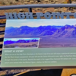
Here is the best view of the entire Red Rock Canyon Scenic Drive and surrounding mountains all the way down to Blue Diamond Hill across Hwy 159 just South of the Scenic Drive. It feels as though you are on top of the world as you stand on this spot, and again, it’s an awesome place for portraits with such a stunning backdrop. Turn around and you can view the La Madre Ridgeline Cliffs at the back (North) of the Red Rock Canyon Scenic Drive area. Interestingly enough, from the top of those cliffs this high scenic drive viewpoint looks microscopic! See that perspective in the La Madre Mountain Western Approach videos where I traverse the top of the La Madre Ridgeline cliffs. However, I still see this viewpoint as one of the best viewpoints anywhere accessible by a street vehicle. It’s a sanctuary of peace.
Trailheads at the Scenic Drive High Point Viewpoint:
- You can access the Grand Circle Loop Trail from this viewpoint, but it’s not a great place to start hiking. There are too few parking spaces, and these should be reserved for those who want to drive the loop and view Red Rock Canyon from their vehicle. Since this is a half-way point along the Grand Circle Loop Trail it could be a good place to have a friend pick you up if you ran out of energy and needed to stop here. However, cell phone coverage may be spotty around the Grand Circle Loop Trail, so good luck contacting your friend!
White Rock Mountain Trailhead
This short unpaved road is not really a viewpoint. It’s a trailhead.
Trailheads at the White Rock Mountain Trailhead Area:
- The White Rock Mountain Loop Trail: This is a great 5-mile trail for walking or trail running. Notice the dramatic change in terrain between the South side and North side of White Rock Mountain.
- White Rock Spring: Take a left onto the White Rock Mountain Loop Trail and within less than a quarter-mile there’s a turnoff to the beautiful, peaceful White Rock Spring!
- The Keystone Thrust Trail: This trail takes you along the Southern base of the La Madre Ridgeline where you can traverse the world-famous Keystone Thrust Fault.
- Access to La Madre Springs: This beautiful year-round spring is on the North side of White Rock Mountain. There are remains of an old historic Miner’s Cabin near the summit of La Madre Springs.
- The Grand Circle Loop Trail: You can also catch the Grand Circle Loop Trail here.
Willow Springs Trailhead and Picnic Areas
The Willow Springs Trailhead and Picnic Areas are actually a short (paved) road to 2 great picnic areas (lower and upper) and a short walkway to view petroglyphs and ancient cooking pits. You’ll notice this side of the canyon has dramatically more lush vegetation than the other side of the canyon. It’s like you’re in a different climate zone due to the streams and springs running off the surrounding canyons. This is the best picnic area on the Red Rock Canyon Scenic Drive and includes picnic tables and restrooms.
Trailheads and Trailhead Access at the Willow Springs Trailhead and Picnic Areas:
- Lost Creek Canyon: This is a great first canyon to start developing your Rainbow Mountains Canyons navigation skills. Lost Creek Canyon is the canyon at the base of North Sandstone Peak.
- Petroglyph Wall: This is perhaps the easiest access to view ancient petroglyphs in Southern Nevada. For background see the 74-page Master of Arts Degree in Archaeology thesis “Valley of Fire Petroglyphs: A New Perspective On An Old Idea” by Eric Pacl.
- Children’s Discovery Trail: This one-mile interpretive trail is great for introducing children to the botanical, geological and historical features on this environment. In the past there has been a self-guided information brochure. You might want to pick the brochure up at the Visitor Center. The brochures at the trailhead may be missing on the day of your visit.
- White Rock Mountain Loop: This is an awesome 5-mile loop for a daily workout hike or run. It’s beautiful with its contrast between the lush vegetation terrain on the North side of the mountain and the more arid desert terrain on the South side. Don’t miss the detour to beautiful, peaceful White Rock Springs!
- La Madre Springs: This is a year-round spring with cascading waterfalls at many points creating lush plant life. The upper trail is often overgrown and can be a challenge.
- Miner’s Cabin: This is an old historic miner’s cabin recalling Nevada’s colorful mining history at the turn of the 19th-20th Century.
- SMYC Trail and the Rainbow Mountains Eastern Baseline Trails: This is the Northernmost of the 4 Rainbow Mountains Eastern Baseline Trails. Experience the Jurassic Era Sandstone base of these beautiful peaks.
- Rocky Gap Road: With access to North Sandstone Peak; North Limestone Peak; Bridge Mountain, Lovell Canyon and many other destinations in the Rainbow Mountains, the Wilson Ridge and the La Madre Ridgeline.
- Grand Circle Loop: You can catch the Grand Circle Loop Trail near the lower Willow Springs Picnic Area. If you want to take this trail in smaller bites, the distance along the West end of the loop to the Visitor Center is about a third of the entire loop.
- Summit Route to the La Madre Ridgeline: This is perhaps the easiest route to reach the spectacular La Madre Ridgeline. However, it’s challenging so set aside a long day in the Spring or Fall.
- Western approach to La Madre Mountain: This adventure reaches the La Madre Ridgeline then takes it in the Eastern direction nearly to El Bastardo Peak.
- La Madre Ridgeline Grand Crossing: Willow Springs is on this ambitious, spectacular route route and a good jumping off point to experience a central portion of the route.
As you can imagine by the above list, you could easily devote an entire season or year to adventures from the Willow Springs Trailhead and Picnic Areas.
Ice Box Canyon Viewpoint/Trailhead
The Ice Box Canyon Viewpoint/Trailhead on the Red Rock Canyon Scenic Drive features the popular Ice Box Canyon trailhead. The trail involves a lot of climbing over large sandstone boulders as you make your way up Ice Box Canyon. I understand it may be possible to ascend all the way to the top of the Rainbow Mountains Upper Crest Ridgeline from this point. However, that is a very challenging adventure I have not yet experienced. You can take a brief walk along the base of the mountains here and experience the lush desert garden vegetation without climbing over any sandstone boulders or ascending the canyon.
Trailheads at the Ice Box Canyon Viewpoint:
- Ice Box Canyon Trail: This is a great second Rainbow Mountains Eastern Canyon to develop your canyon navigation skills. It’s more difficult than Lost Creek Canyon, but still less challenging than the other canyons. Ice Box Canyon is the canyon between North Sandstone Peak and Bridge Mountain.
- SMYC Trail: From below the Ice Box Canyon Trailhead you can catch the SMYC Trail, the Northernmost of the beautiful Rainbow Mountains Eastern Baseline Trails and take the SMYC Trail (right turn) to Willow Spring.
- Dales Trail: From below the Ice Box Canyon Trailhead you can catch Dale’s Trail, the second Rainbow Mountains Eastern Baseline Trail, and take it South (left turn) to Pine Creek Canyon.
Pine Creek Canyon Viewpoint/Trailhead and Picnic Area
The Pine Creek Canyon area has a great forested area for picnics, equipped with picnic tables. Here you are at the base of Bridge Mountain, Juniper Peak, Rainbow Mountain and near the base of Mt. Wilson. Pine Creek Canyon itself is incredibly beautiful the further in you ascend. It is split into two separate canyons by the pyramid shaped Mescalito Pyramid Peak. Pine Creek Canyon is to the left (South); Fern Canyon is to the right (North). However, for all these mentioned points of interest, along with Ice Box Canyon there is heavy tangly brush in which it is easy to lose your way! I’ve been stopped by the wall of brush more than once!
Trailheads at the Pine Creek Canyon Viewpoint:
- Fire Ecology Trail and Picnic Area: This short half-mile trail guides you through a recovering burn area. There are picnic tables along beautiful Pine Creek in a shaded Ponderosa Pine grove.
- Pine Creek Canyon Loop: This short loop of about a mile takes you to the openings of Pine Creek Canyon and Fern Canyon at the base of Mescalito Pyramid Peak.
- Dales Trail: A right turn (North) on the Pine Creek Canyon Loop puts you on Dales Trail, second trail to the North on the beautiful Rainbow Mountains Eastern Baseline Trails. Dales Trail will take you to Icebox Canyon where you can catch the SMYC Trail to Willow Spring.
- Knoll Trail: The Knoll Trailhead is located on the South side of the Pine Creek Canyon Loop. This Rainbow Mountains Eastern Baseline Trail will take you to the entrance of Juniper Canyon, and further beyond to the entrance of Oak Creek Canyon.
- Arnight Trail: Less than a mile South along the Knoll Trail, you’ll find the Arnight Trail split: A slight left. The Arnight Trail, one of the Rainbow Mountains Eastern Baseline Trails will take you to the Oak Creek Canyon Trailhead.
- Pine Creek Canyon: This canyon, on the left side of Mescalito Pyramid Peak, will take you to spectacular Terrace Canyon, up to Rainbow Wall then over to Oak Creek Canyon for an incredible loop. You’ll need good Class 3-4 rock climbing skills and possibly two days.
- Terrace Canyon: A left split in Upper Pine Creek Canyon will take you to beautiful Terrace Canyon. Plan on some challenging canyon navigation to get there!
- Juniper Canyon: Take the Knoll Trail from the South side of the Pine Creek Canyon Loop. Then take a right turn into the next canyon to the South. That’s Juniper Canyon, the canyon between Rainbow Mountain and Juniper Peak. Plan on some challenging canyon navigation in Juniper Canyon! You can continue up Juniper Canyon to Juniper Peak Summit.
- Rainbow Mountain Peaks Access: Juniper Peak, Rainbow Mountain, Mescalito Pyramid Peak
Similar to the Willow Springs Trailhead and Picnic Area, you could easily devote an entire season or year to adventures from the Pine Creek Canyon Viewpoint/Trailhead and Picnic Area..
Oak Creek Canyon Trailhead
This is not really a viewpoint, but a short half-mile unpaved road leading to the trailhead area which is one of the access points for Mt. Wilson and Juniper Peak. However, there is a nice trail here that traverses the base of the mountains along a beautiful desert garden area. If you’re just taking the Red Rock Canyon Scenic Drive you may want to bypass this area. You will have had an awesome experience of the canyon by this point.
Trailheads at the Oak Creek Canyon Trailhead Area:
- Arnight Trail: This one-mile “cut-off” trail heads straight for the entrance of Juniper Canyon, and is the most direct access to Juniper Canyon and Juniper Peak.
- Knoll Trail: Take the Oak Creek Canyon Trail toward Oak Creek Canyon. Then, at the entrance of Oak Creek Canyon, take a right (North) onto the Knoll Trail which skirts the base of Rainbow Mountain to Juniper Canyon and then on to Pine Creek Canyon.
- Oak Creek Canyon Trail: Head straight up the Oak Creek Canyon Trail into Oak Creek Canyon. This is possibly the most challenging of all the Rainbow Mountains Eastern Canyons. Here you will find thick brush, huge boulders, tall ledges and a creek to navigate! Hopefully, you first got some experience with this kind of navigation in Lost Creek Canyon and Icebox Canyon. From Upper Oak Creek Canyon you could summit Rainbow Wall, then circle down through Terrace Canyon to Pine Creek Canyon. If you do this, have advanced Class 3-4 rock climbing skills and prepare for a two-day adventure.
- Juniper Canyon: The Arnight Trail at this Oak Creek Canyon Trailhead Area will take you to the entrance of Juniper Canyon.
- Rainbow Mountain Peaks Access: Juniper Peak, Rainbow Mountain
Scenic Drive Exit Parking Area
This is a fairly large unpaved parking area you can access at the exit of the Red Rock Canyon Scenic Drive right on Hwy 159. Parking here is free and you don’t need to enter the fee-regulated Red Rock Canyon Scenic Drive. In addition, you don’t need to circle the entire Red Rock Canyon Scenic Drive in order to get to this point.
Trailheads at the Scenic Drive Exit Parking Area:
- Arnight Trail Access: There is a very direct, but unmarked, access path from this parking area to the Arnight Trailhead.
- Oak Creek Canyon Trail Access: This trailhead is only just a few feet from the Arnight Trailhead and so the same access path from the Scenic Drive Exit Parking Area works here too.
- Knoll Trail Access: Again, the same access path works, only you’ll need to head up the Oak Creek Canyon Trail to catch the Knoll Trail at the entrance of Oak Creek Canyon.
- Juniper Canyon Access: Take the access path to the Arnight Trailhead, then on to Juniper Canyon.
- Juniper Peak Access: Take the access path to the Arnight Trailhead, then on to Juniper Canyon and Juniper Peak
- Grand Circle Loop Trail Access: Check the map on the Grand Circle Loop Trail page to chart a course to connect with the Grand Circle Loop Trail which is close to the Scenic Drive Exit Parking Area.
Scenic Overlook on Hwy 159 Just South of the Red Rock Canyon Scenic Drive Area (Outside the Fee Area)
Just as the high point scenic drive turnoff affords sweeping vistas of Red Rock Canyon and its surroundings, this lowest scenic viewpoint on Hwy 159 at the bottom (South end) of Red Rock Canyon offers sweeping views all the way up to the summit of the canyon. In addition, there is a great picnic area here. You don’t need to enter the canyon to enjoy this viewpoint. It is accessible directly off of Blue Diamond Road (Hwy 159) near the Red Rock Canyon Scenic Drive exit.
Trailheads at the Scenic Overlook
- Grand Circle Loop Trail Access: Check the map on the Grand Circle Loop Trail page to chart a course to connect with the Grand Circle Loop Trail which is close to the Scenic Overlook
- Blue Diamond Hill Western High Ridge: This is a great parking area to access the Blue Diamond Hill Western High Ridge route. That route offers some of the best views of the colorful Rainbow Mountains.
I’m thinking that this turnoff might be a good jumping off point for a Blue Diamond Mountain adventure, but that is in the future.