La Madre Mt., El Padre Mt., Burnt Peak – Overview
This adventure summits three of the highest peaks in the La Madre Mountains Wilderness to the West of Las Vegas, Nevada: La Madre Mountain, El Padre Mountain and Burnt Peak. I attempted to add El Bastardo Mountain, but ran out of light due to spending too much time navigating a lower wash. Who could know that the entire adventure would take about 17 hours, beginning around 7:30am at the intersection of Kyle Canyon and Harris Springs Roads and ending 12:30am the next morning after navigating a final 2-mile wilderness ridge only by the light of a three-quarter moon and then about 5-8 miles of unpaved roads back to my starting point! Wilderness emersion doesn’t get better than this! Curiously, I have done the entire 18-mile Mt. Charleston Loop recently in 7.5 hours, which gives an indication of the difficulty of today’s adventure.
La Madre Mt., El Padre Mt., Burnt Peak – Spectacular Views
The La Madre Mountain, El Padre Mountain and Burnt Peak circuit offers incredible views all along the way including the Mt. Charleston Wilderness with Griffith Peak, Charleston Peak, Lee Peak, Mummy Mountain, Fletcher Peak and Angel Peak to the West. Then there is the Sheep Range, Fossil Ridge and Gass Peak to the Northeast. Add spectacular aerial views of Las Vegas Valley and the Las Vegas Strip with Frenchman Mountain and Lake Mead in the background to the East. Then add Calico Basin, Calico Hills, Damsel Peak, Red Rock Park, Turtlehead Peak, White Rock Mountain and the Rainbow Mountains all the way to Potosi Mountain to the Southwest including Bridge Mountain, North Peak, Rainbow Mountain, Juniper Peak, Mt. Wilson, Indecision Peak and Windy Mountain.
I imagine the total distance was greater than a marathon with an elevation gain from the lowest to the highest point being about 4,000ft and a total elevation gain of around 6,000ft adding up all the ascents and descents.
Summary of Area Summits
La Madre Mountain: 8154ft
El Padre Mountain: 8093ft
Burnt Peak: 7900ft
El Bastardo: 7986ft
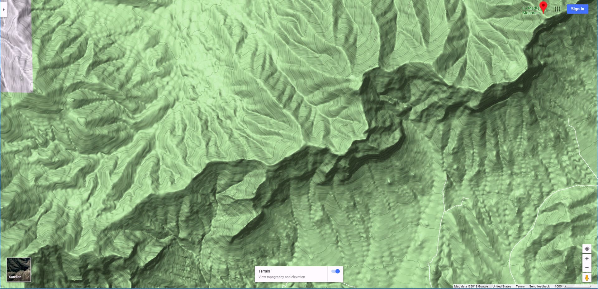
La Madre Mt., El Padre Mt., Burnt Peak – Trailhead Directions
Begin at the intersection of Kyle Canyon Road and Harris Springs Road. There is a parking area on the right side of Kyle Canyon Road just about 100 yards beyond where it intersects with Harris Springs Road. Head 3-4 miles up Harris Springs Road to where it intersects a 4wd road 3-4 miles North of the base of La Madre and El Padre Mountains. At the upper end of the 4WD road there is a turn-around loop. There is no marked trailhead, but your adventure begins here.
La Madre Mt., El Padre Mt., Burnt Peak – Trail Observations
Harris Springs Road to 4WD Cutoff Road
From the generous parking area at the lower intersection of Kyle Canyon Road and Harris Springs Road I began by mountain bike up the unpaved Harris Springs Road about 3 miles to an unmarked turn-off onto a 4WD road to the left heading up toward La Madre Mountain. This is where I left the mountain bike and continued on foot. The incline plus the rockiness of the road made it easier to travel on foot than try to push a mountain bike further upward. At this point you are in a scattered Joshua Tree forest. After about a mile the Joshua Trees give way to Junipers and Pinion Pines.
La Madre Mountains Camping Area and Mike Alcorn Trail
Higher up there’s a nice camping area with numerous pullout camping spots as you approach the official La Madre Mountains Wilderness sign. Added to this sign for the first time was a lower banner sign stating that the Mike Alcorn Trail, 2.6 miles, led to La Madre Mountain. I decided to locate the Mike Alcorn Trail and explore it. I continued up the 4WD road, keeping to the right, until it ended in a turn-around. I never did find any markings for the Mike Alcorn Trailhead, but there was a trail that branched off from the turn-around. I’ll call that the Mike Alcorn Trail.
First Section of Mike Alcorn Trail Wash
The Mike Alcorn Trail headed down into a wash, then continued up that wash. I had attempted that wash before but it was so littered by brush that in that earlier adventure I had headed across that wash and up to the top of the next ridge. That ridge had led me all the way to the summit of La Madre Mountain with a great view the entire way and relatively firm ground to navigate. But on this day I decided to stay in the wash to explore what looked like the Mike Alcorn Trail. Indeed, the wash had been cleared of brush and there were plenty of cairns marking the way. However, you really didn’t need the cairns if you just knew to stay in the wash. The wash surface was mostly fine gravel, not as firm as the ridge above, and there was no view other than the sides of the wash.
Left Branching Wash, Rapid Ascent
After a mile or two there were a series of cairns leading to the left out of the wash and into another wash that continued up the base of the higher ridge. This was became rather steep with larger rocks and boulders to navigate. Views of the Mt. Charleston Wilderness began to open up behind framed in the walls of the wash canyon. There were always steps (sometimes giant steps) making the ascent, which dramatically increased, still relatively manageable. However I did see numerous off-branching use trails heading up to the top of the main approach ridge I had taken before. Seems others had gotten tired of the wash and wanted to get out! I stayed in the wash to get the full experience of this approach. The was really slowed me down and ate up a lot of time. Take the higher ridge next time!
Final Approach Ridge to La Madre Mountain
Finally, just above the Devil’s Slide, I ascended to the higher approach ridge where spectacular views of the surrounding wilderness suddenly opened up. As you approach the summit of La Madre Mountain and the ridge becomes a cliff, just head over to the opposite side of the ridge where the incline is more gradual (I show the exact point in the video). Just below the summit of La Madre Mountain where the going became much steeper and cliffy, I crossed over the ridge again to a more gradual ascent. From this point it was a short walk to La Madre Mountain summit with all the spectacular views noted above!
La Madre Mountain to The Notch Between La Madre and El Padre Mountains
Just below the summit there is a faint trail leading down toward the Notch between La Madre Mountain and El Padre Mountain. This ridge route is relatively manageable, though steep and gravely in places. Once at the Notch between La Madre Mountain and El Padre Mountain it appears that there is a route leading downward to Calico Basin. I had earlier ascended this route from Calico Basin and nearly made the top of the Notch. From above the route to and from Calico Basin looks manageable so I’ll try it again, probably next Spring. From the Notch there are incredible views of the Las Vegas Valley beautifully framed by the surrounding cliffs. See the video and slide show on this page.
Ascent to El Padre Mountain Summit
Upon crossing the Notch, the ascent toward El Padre Mountain Summit begins. This ascent is far more gradual and easier than the earlier ascent to La Madre Mountain Summit. Where La Madre Mountain Summit area is a smaller, sharp peak, El Padre Mountain Summit area, though a couple hundred feet lower, is a long ridge of about an eighth to a quarter mile. All along this ridge there are spectacular views of the Las Vegas Valley and Red Rock Park, Calico Basin, the Calico Hills and Rainbow Mountains below. The cliff edge is sheer with a 2-3000ft drop, but there is ample room to navigate it’s upper ridgeline all the way to the official summit of El Padre Mountain.
El Padre Mountain Summit to Burnt Peak Summit
From the summit of El Padre Mountain take the ridge downward toward Burnt Peak. I headed down a faintly marked use trail just below and to the right of the ridge top. Upon approaching Burnt Peak you are met with a barrier cliff about 15ft high. Just take a right and head downward along the lower edge of the cliff until a more gradual way opens up just below Burnt Peak. At this point the sun was setting fast and I decided to skip El Bastardo Mountain and take the wilderness ridge below Burnt Peak to 1-2 miles back down to where it connected with the high point on the 4WD road that would lead back down to Harris Springs Road and finally my starting point on Kyle Canyon Road.
Descent from Burnt Peak Summit By Moonlight
I made the descent ridge below Burnt Peak in the last waning light. Fortunately, on this night there was a brilliant three-quarter moon illuminating the entire area and casting distinct moon shadows. It seemed better to navigate just by the light of the moon rather than use a head lamp which would have given a brighter immediate area around me but taken away the larger view. A light tower on Angel Peak and lights North of Las Vegas added perspective. One important navigation note: About 3/4ths down this descent ridge you need to navigate over to a ridge to the right in order to end up at the connection with the 4WD road. I discovered this on an earlier trip down this ridge where I missed the 4WD road connection and had to cross a huge wash to get back to the 4WD road. At night this could be difficult. On this trip I actually over-compensated and ended up back in the Mike Alcorn wash trail. But it was easy from there to head back up to the 4WD road connection.
Wilderness Navigation By Night
There’s something incredibly beautiful and peaceful about navigating wilderness in moonlight. This was an unexpected joy. However, had there been no moonlight and had I not previously navigated up and down the Burnt Peak descent ridge in the light, things might have gone a lot differently and a successful conclusion of this adventure might have been in question. In addition, I have clocked in countless hours of wilderness navigation experience, without a GPS, which also contributes to success of navigating wilderness stretches like this.


