Lost Creek Canyon | Petroglyph Wall | Willow Spring LoopSpectacular Waterfall in Upper Lost Creek CanyonLost Creek Canyon | Petroglyph Wall | Willow Spring LoopBeginning the Lost Creek Trail Lost Creek Canyon | Petroglyph Wall | Willow Spring LoopAfter Crossing a Dry Wash the Trail Enters a Lush Vegetation ZoneLost Creek Canyon | Petroglyph Wall | Willow Spring LoopLost Creek Cascading Over Boulders in the CanyonLost Creek Canyon | Petroglyph Wall | Willow Spring LoopHeavy Rain the Previous Day Increases the FlowLost Creek Canyon | Petroglyph Wall | Willow Spring LoopIce Cold Water from Snow Melt in the Rainbow Mountains AboveLost Creek Canyon | Petroglyph Wall | Willow Spring LoopWater in the Desert is Always a Rare PhenomenonLost Creek Canyon | Petroglyph Wall | Willow Spring LoopStarting Out on the Willow Spring Trail at the Upper Parking AreaLost Creek Canyon | Petroglyph Wall | Willow Spring LoopAgain, Soon You'll Leave the Arid Desert and Enter a Lush Green ZoneLost Creek Canyon | Petroglyph Wall | Willow Spring LoopAttractive Stone Stairways Make the Going EasyLost Creek Canyon | Petroglyph Wall | Willow Spring LoopAscending Along the Base of the Rainbow MountainsLost Creek Canyon | Petroglyph Wall | Willow Spring LoopLarge Variety of Plant Life from Yucca to PinesLost Creek Canyon | Petroglyph Wall | Willow Spring LoopJurassic Era Sand Dunes Reddened with Iron Paint the SoilLost Creek Canyon | Petroglyph Wall | Willow Spring LoopCounterclockwise Direction on Loop Helps Avoid Missing This Narrow TurnLost Creek Canyon | Petroglyph Wall | Willow Spring LoopThis Cave Under the Rock May Have Been a Native American Family HomeLost Creek Canyon | Petroglyph Wall | Willow Spring LoopView Up into the Rainbow Mountains, Somewhere Below the Buffalo Wall AreaLost Creek Canyon | Petroglyph Wall | Willow Spring LoopAnother Potential Native American Shelter at the Base of the Rainbow MountainsLost Creek Canyon | Petroglyph Wall | Willow Spring LoopNow Circling the Loop East of Rocky Gap RoadLost Creek Canyon | Petroglyph Wall | Willow Spring LoopNatural Art Like This Has a Rare BeautyLost Creek Canyon | Petroglyph Wall | Willow Spring LoopEvery Boulder and Ledge Slowly Etched by the Elements Over TimeLost Creek Canyon | Petroglyph Wall | Willow Spring LoopCactus Garden on the East Side of Willow Spring LoopLost Creek Canyon | Petroglyph Wall | Willow Spring LoopMore Cactus in the Arid Zone, Approaching the End of the LoopLost Creek Canyon | Petroglyph Wall | Willow Spring LoopPetroglyph Wall TrailheadLost Creek Canyon | Petroglyph Wall | Willow Spring LoopPetroglyph WallLost Creek Canyon | Petroglyph Wall | Willow Spring LoopFaint Petroglyphs to the Left of Petroglyph WallLost Creek Canyon | Petroglyph Wall | Willow Spring LoopThin Film of Dark Iron Oxidation Etched Through to Create PetroglyphsLost Creek Canyon | Petroglyph Wall | Willow Spring LoopThe Meaning of These Petroglyphs Remains a Mystery
Overview | Petroglyph Wall & Lost Creek Canyon | Red Rock Canyon National Conservation Area, Nevada
Petroglyph Wall, Lost Creek Canyon and the Willow Spring Loop are three separate, brief adventures in the Willow Springs area of Red Rock Canyon. The trailheads are easy to reach by car and feature picnic areas and restrooms. These are a great family experience and a way to introduce young children to significant history and to the wilderness in Red Rock Canyon and the Rainbow Mountain Wilderness. It’s a great introduction for adults too!
Willow Spring Loop
There are few 1.1-mile trails anywhere the offer such a rich diversity of landscape and experience as the Willow Spring Loop. On the East side of the loop you are in a arid desert environment populated by cacti and yucca plants. Only 1/8th mile away, across Rocky Gap Road you’re in a lush pine forest with streams, waterfalls and a wall of vegetation so thick that passing through it gives the feeling of being in a tunnel. And, there is human history along the trail. You can see sites where Native Americans made their homes, cooked their meals, raised families and left notes on the rock walls.
In addition, for young children and others relatively new to the wilderness and wilderness navigation, picking out the exact pathway can be somewhat of a challenge in places. There are multiple route choices along the way. Many are marked, some are not. It’s not hard to go off course, and that can be a good thing. Have your young children lead the way and find the route. Ask them how they are making their route decisions. This is a great place for route-finding experimentation, and very safe as Rocky Gap Road, the main road in the area, passes right through the loop and is visible at many points along the way.
Finally, many well designed, attractive interpretive signs tell an unfolding story of the wilderness and its history.
Petroglyph Wall
With ancient dwelling sites and cooking pits scattered throughout the area and rock walls just waiting for artists, it’s a no brainer what to do while waiting for the next meal. A few great examples of rock art remain to be discovered and puzzled over. Petroglyph drawings create an enduring connection between the artist and the viewer — a connection that spans culture and time.
Lost Creek Canyon
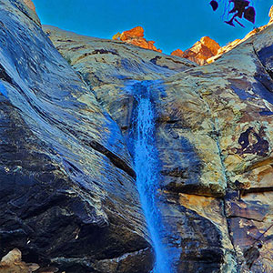
It was the day after a heavy rainstorm and Lost Creek was flowing strong, singing as it cascaded over rocks and through tight spaces. And, the reward at the upper end of Lost Creek Canyon was a waterfall shooting over the cliff ledge above like a fire hose!
An added plus to the Lost Creek Canyon Trail is that it is also a Children’s Discovery Trail with vivid descriptive displays all along the way.
Directions to the Start Point | Petroglyph Wall & Lost Creek Canyon | Red Rock Canyon National Conservation Area, Nevada
Narrative Guide | Petroglyph Wall & Lost Creek Canyon | Red Rock Canyon National Conservation Area, Nevada
Petroglyph Wall
This short and easy trail located at the upper end of the Willow Spring Picnic Area is probably less than 50 yards long and ends with a rock wall filled with ancient petroglyphs. The word Petroglyph is far more ancient than the drawings. It comes from two ancient Greek words: Petros (rock) and Glyph (Purposeful drawing, “character” as a letter or sign.) And, the rock surface is perfect for drawing. The rock is an ancient solidified sand dune from the Jurassic Era. The light sand-colored rock is covered by a thin black film caused by the oxidation of the iron that leached up into the sand from below. It was relatively easy for ancient artists to chip away the dark film, exposing the lighter sandstone beneath and in the process creating designs and messages.
One can’t help but wonder about the meaning of these drawings. To discover their meaning is to create a connection with the artist. I know of no more complete study of the petroglyphs in this area than the 74-page Master of Arts Degree in Archaeology thesis “Valley of Fire Petroglyphs: A New Perspective On An Old Idea” by Eric Pacl. Eric brings to the discussion both a big picture view and a very detailed analysis of the origin and meaning of the petroglyphs found in the Valley of Fire State Park. Download the entire thesis here.
Lost Creek Canyon
The short .7-mile out and back Lost Creek Canyon Trail begins at the lower Willow Springs parking area. The trail heads toward a canyon in the sandstone cliffs of the Rainbow Mountains just to the West. After passing through a wash, the trail begins to pass through a wall of vegetation typical to the canyons at the Eastern base of the Rainbow Mountain Peaks (See the adventures in Pine Creek Canyon, Oak Creek Canyon and First Creek Canyon for examples). Soon the trail emerges onto a boardwalk overlook of Lost Creek. This is the end of the easiest stretch.
The remaining stretch will involve balancing on rocks in order to keep your feet dry during a number or creek crossings. If the rocks are wet, watch your footing. There are a few rock stairways and more winding through tunnels of thick brush. But the reward is the impressive waterfall at the end! The flow is especially strong following a rainstorm. During the hot Summer months the creek and waterfall may become a trickle, or even dry.
Willow Spring Loop
The best place to begin this loop is at the Willow Spring Loop sign in the upper Willow Spring Picnic Area. Take the loop in a counterclockwise direction. Why this suggestion? I started the loop in a clockwise direction taking it on the way back from the Lost Creek Canyon Trail. In doing so, I missed a tight, unmarked left turn through a narrow rock opening. Instead of continuing along the Willow Spring Loop, I ended up continuing on the Children’s Discovery Trail back to the lower parking area. So, I reversed the direction of the loop and the route became more clear. There are a number of branching route choices along this loop, and the Willow Springs Loop doubles and triples as a number of other trails: Lost Creek, Children’s Discovery, White Rock Mountain Loop. All that aside, while it’s easy to go off track, it’s very hard to get lost on the loop.
After beginning in a more arid desert environment at the trailhead, you’ll cross a wide canyon wash. The trail continues on the other side of the wash and begins to skirt the base of the Rainbow Mountain Peaks. The floral zone dramatically changes, becoming a lush, green Ponderosa Pine and Pinyon Pine forest. The rock formations give additional beauty to this stretch. You’re now descending toward the Lost Creek Canyon area. Shortly after passing through the aforementioned narrow rock opening, watch for a cave-like opening under a large flat rock. This may have been used as a dwelling place by the nomadic Native Americans who occupied the area during the cooler months.
Beyond the cave opening you will find yourself on the Lost Creek Canyon Children’s Discovery Trail. Continue to the lower Willow Spring parking area and cross Rocky Gap Road to continue the loop. The trail opening on the opposite side of Rocky Gap Road may not be obvious. Just navigate to head left (North) along the base of White Rock Mountain. A trail will appear. It may not say “Willow Spring Loop“, but you’re back on the loop. Continue to skirt the base of White Rock Mountain to the upper parking area, passing through some beautiful rock formations and cactus gardens along the way. Upon arrival at the upper parking area, you’ve completed the Willow Spring Loop!
Summary
Article Name
Petroglyph Wall & Lost Creek Canyon | Red Rock Canyon NCA, Nevada
Description
View Petroglyph Wall, a waterfall in Lost Creek Canyon and the Willow Spring Loop in Red Rock Canyon National Conservation Area, Nevada. These are three short trails packed with discovery and adventure for all ages.
Author
David Smith
Publisher Name
LasVegasAreaTrails.com
Publisher Logo
Translate »
<
<
<
<
<
<
<
<
<
<
<
<
<
<
<
<
<
<
<
<
<
<
<
<
<
<
<
<
<
<
<
<
<
<
<
<
<
<
<
<
<
<
<
<
<
<
<
<
<
<
<
<
<
<
<
<
<
<
<
<
<
<
<
<
<
<
<
<
<
<
<
<
<
<
<
<
<
<
<
<
<
<
<
<
<
<
<
<
<
<
<
<
<
<
<
<
<
<
<
<
<
<
<
<
Manage Cookie Consent
To provide the best experiences, we use technologies like cookies to store and/or access device information. Consenting to these technologies will allow us to process data such as browsing behavior or unique IDs on this site. Not consenting or withdrawing consent, may adversely affect certain features and functions.
Functional
Always active
The technical storage or access is strictly necessary for the legitimate purpose of enabling the use of a specific service explicitly requested by the subscriber or user, or for the sole purpose of carrying out the transmission of a communication over an electronic communications network.
Preferences
The technical storage or access is necessary for the legitimate purpose of storing preferences that are not requested by the subscriber or user.
Statistics
The technical storage or access that is used exclusively for statistical purposes.The technical storage or access that is used exclusively for anonymous statistical purposes. Without a subpoena, voluntary compliance on the part of your Internet Service Provider, or additional records from a third party, information stored or retrieved for this purpose alone cannot usually be used to identify you.
Marketing
The technical storage or access is required to create user profiles to send advertising, or to track the user on a website or across several websites for similar marketing purposes.