Overview | Sexton Ridge Descent from Griffith Peak | La Madre Mountains Wilderness | Spring Mountains, Nevada
Sexton Ridge is Largely Untouched Due to Difficulty Getting There
Sexton Ridge from Griffith Peak to Lovell Canyon Trailhead Involves Nearly 6,000ft Elevation Differential
From the
Lovell Canyon Trailhead at the bottom, the ridge involves between 5,000 and 6,000ft ascent or descent, depending on the direction you are going. In an out and back trip no matter what direction you take
Sexton Ridge you’re ascending and descending far more than what is involved in doing the
Charleston Loop to the summit of
Charleston Peak!
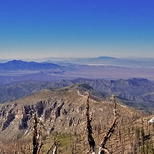
Sexton Ridge is a Recently Burned Out Forest
Another limiting factor that tends to keep people away from
Sexton Ridge is the fact that its beautiful ancient
bristlecone pine forest was burned out in the
2013 Carpenter 1 Fire leaving only charred remains of the trees. There is some grass, small plants and about 1,000 feet below the ridge summit, a few trees begin. For someone wanting the hike in a forest,
Sexton Ridge is not the place to go.
The Views on the Sexton Ridge are Spectacular!
Sexton Ridge Has More Snow-Free Months Annually
Another benefit of
Sexton Ridge is that it promises to be open (snow free) earlier in the Spring and later in the Fall due to its orientation to the sun.
Directions to the Start Point | Sexton Ridge Descent from Griffith Peak | La Madre Mountains Wilderness | Spring Mountains, Nevada
Head up
Hwy-95 from
Las Vegas and take a left at the
Kyle Canyon exit (less than 30 miles from the
Las Vegas Strip). Travel another 20 miles to the
South Loop Trailhead. You’ll pass through
Charleston Village, pass a fire station, the road will bend to the left, cross a short bridge and then head up about a half mile where you will take the first right after passing some cabins, then on up to the
South Loop Trailhead parking lot (which is also the parking lot for
Cathedral Rock). By the way, in this parking lot are the best restrooms of all the
Mt. Charleston area trailhead parking lots with actual flush toilets and sinks with running water.
↓ Narrative Guide ↓
Narrative Guide | Sexton Ridge Descent from Griffith Peak | La Madre Mountains Wilderness | Spring Mountains, Nevada
Initial Descent Adventure
Ascent to Griffith Peak Summit
From the trailhead, continue past where the
Cathedral Rock Trail splits off to the right. Arrive at the “junction” where the
Charleston Loop reaches the
South Ridge of Kyle Canyon…about 4.25 miles from the trailhead. At the junction turn left toward
Griffith Peak. The summit looks like it is a long steep climb but it is actually only about 1/2th miles from the junction and you’re on the summit before you realize it.
Selecting the Right Descent Ridge from Griffith Peak
From
Griffith Peak Summit there are basically two main ridge descent options (not counting the ridge you just ascended). One option is to descend the ridge toward
Harris Mountain, which descends to a saddle before re-ascending to
Harris Mountain. I’ve documented this ridge route between the two mountains in both directions: The
Griffith > Harris Route and the
Harris > Griffith Route.
The ridge you want today is
Sexton Ridge, which descends down the West side of
Lovell Canyon. You will see
Lovell Canyon on your left and
Trout Canyon on your right. The ridge is pretty much straight past
Griffith Peak Summit, and then down with a rather steep descent followed by a brief leveling off, then another steep descent followed by a much longer gradual descent.
Limit of Today’s Descent – At This Point I’ve Covered All but 1/2 mile of Sexton Ridge
On this day, as noted, I descended to the edge of the longer gradual descent, when the ridge takes another plunge downward. At this point I was only 1/2 mile from the point I had ascended earlier from
Lovell Canyon. So, there is only 1/2 mile of
Sexton Ridge I have not yet traversed as of this first descent. But that 1/2 mile includes a rather steep cliff area. Perhaps this can be circumvented with little or no climbing beyond class 2. We’ll see on the next pass!
In all,
Sexton Ridge from one end to the other is quite the distance and ascent challenge, requiring as much if not more effort than a marathon, or the
Charleston Loop.