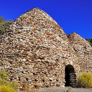
The Death Valley Wildrose Charcoal Kilns, located on Charcoal Kiln Road near Telescope Peak in the Panamint Mountain Range are perhaps the best preserved Charcoal Kilns on earth. Built in 1877 to create charcoal used to smelt lead and silver in the Modock Mines about 25 miles West in the Argus Range, the Wildrose Charcoal Kilns were only used for 2 years. However, when you enter any of the kilns through a generous opening, you can smell the charcoal as if it were burning just yesterday! And the echo inside the kilns is incredible. I played around with that, perhaps a bit too much, but why not? See the video on this page.
If you’re extra ambitious, take the 8.4-mile round trip Wildrose Peak trail (the trailhead is at the left end of the Charcoal Kilns), or continue ascending the road to Mahogany Flat Campground where you will find the 14-mile round trip Telescope Peak trail.
Everything about the Wildrose Charcoal Kilns is local. When you look at the bricks that make up the kilns, and then look at the surrounding mountainside, they naturally blend because they are fashioned from the very stones of those mountains. Even the smell of charcoal is local, made from burning the local Pinion Pines. It took a few days to reduce the pine wood to charcoal, and then a day or so longer to transport the charcoal to the mines by pack animal on wagons, but the charcoal produced burned hot enough and slow enough to smelt metal in the mining furnaces.
The descendants of the pack animals, mules, can still be seen along the roads near the Wildrose Charcoal Kilns. When the operation was shut down, apparently the mules were released into the surrounding area where they thrived and multiplied over the years. Even if you can’t see them, you know they’re there because piles of their droppings are scattered on the roads in the area. I met a very patient family of mules along the road. They circled the car a few times and just stood there, about 6 feet away. I think they were expecting a hand out, which is not a good idea for 2 reasons: First, they need to continue relying on the natural food supply, which is actually more healthy for them. Second, I’ve heard that they have a temper and may bite and kick if you get too close! The mule family is pictured in the slide show and the video on this page, rounding off the historic experience of the Charcoal Kilns.
From Las Vegas take Hwy 190 through Pahrump. Continue on 190 through Death Valley. Pass Furnace Creek and Stovepipe Wells. Turn left at Emigrant Campground onto Emigrant Canyon Road. Pass Skidoo Rd, Aguereberry Point and Wood Canyon Rd turnoffs continuing to Rattlesnake Gulch where you’ll turn left onto Charcoal Kiln Rd. Continue on Charcoal Kiln Road to the Wildrose Charcoal Kilns. The pavement will end about 2 miles before the Wildrose Charcoal Kilns, but the unpaved road is in good condition for 2WD travel.


Return often to experience one new adventure each week! From the home page scroll to “Most Recent Adventures“. More about David Smith…
The trail adventures on this website require proper conditioning, preparation and safety precautions. There are many factors beyond our control including weather conditions, unstable ground, loose rocks, insects and snakes, people you may encounter, your own level of physical conditioning, the potential of getting lost just to mention a few. While this site offers guidance, helpful tips, direction and training, the reader assumes full responsibility for whatever may occur during their trail adventure. Have fun and be safe!