Overview | Lower Wilson Ridge Loop | Lovell Canyon, Nevada
Slide show, week of 8/27/2023
The lower Wilson Ridge Loop is a spectacular stretch along the East side of Lovell Canyon. This stretch is isolated and seldom, if ever, traversed, so images, videos and descriptions of the stretch are rare. Views of the surrounding wilderness ridges, valleys and high points from the stretch give an entirely unique perspective. The majority of this loop is along pathless wilderness ridges. The loop is nearly 20 miles in length so we’ll need to divide this adventure into more than one part.
Route of The Lower Wilson Ridge Loop
The loop begins at the upper end of Lovell Canyon Road. From there take the ridge system to the Wilson Ridge Southern High Point to the Northeast. Then, descend the Wilson Ridge to the South from that high point, continuing along the ridgeline until you see Rocky Gap Road below. Continue along the ridgeline above Rocky Gap Road, finally taking a descent ridge above the road, eventually landing at the intersection of Rocky Gap Road and Lovell Canyon Road. From there, take a right onto Lovell Canyon Road and return to the upper end of the road where you began.
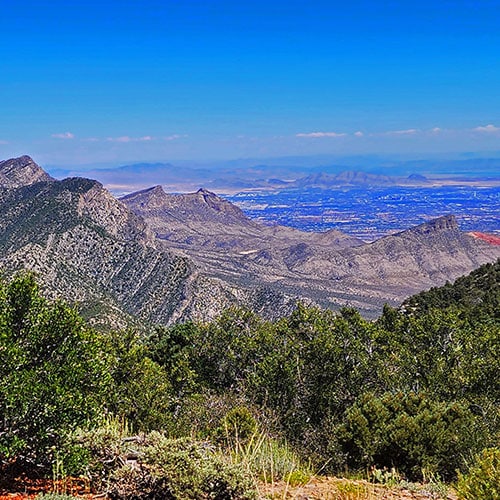
Spectacular Views Along The Lower Wilson Ridge Loop
Here is a short list of the spectacular views you will see along the way:
Terrain Along The Lower Wilson Ridge Loop
And, as mentioned, this stretch of the Wilson Ridge is wild, secluded and seldom traveled, featuring Mountain Mahogany, Pinyon Pine, mountain meadows, beautiful open limestone ledges and recovering burn areas from the 2013 Carpenter Fire. Prepare to ascend, descend and traverse some steep loose rock slopes along the way. You’ll also experience some relatively level, open stretches. In addition, prepare to navigate some thick sharp brushy stretches, especially on the lower approach slopes to the Wilson Ridge. Without proper leg covering (see the video) you can expect “death by a thousand cuts”! And there is no climbing necessary above the level of class 2 (no hands needed, just steep slope walking). In addition to the sage guards I rigged up, my yucca trekking poles were essential.
Best Time of Year for The Lower Wilson Ridge Loop
The best time of year for this adventure is a day with long daylight hours when the temperature in the Las Vegas Valley doesn’t rise above 100 degrees. This puts you in late Summer/Early Fall or late Spring/Early Summer. For each day on the loop I packed between 4-5 liters of liquid (mostly water), and ended up drinking it all!
Directions to the Route Starting Point | Lower Wilson Ridge Loop | Lovell Canyon, Nevada
Take Hwy 160 from Las Vegas toward Pahrump. The highway ascends over a “hump” (the Potosi Mountain area). There’s a saying around here, “Over the hump to Pahrump”. Well, you’ve just traveled over that hump. Around 4-5 miles from the point where the highway begins to descend toward Pahrump there is a well-marked sign on the right for Lovell Canyon Road.
Views Along Lovell Canyon Road
Lovell Canyon Road is a beautiful stretch passing through a Joshua tree forest that soon becomes populated predominately with junipers and pines. There are ridges and meadows and many camping pull-outs along the way. This stretch reminds me a lot of the high desert area around Bend Oregon. Very open and majestic. All the while you’re looking up at the Spring mountains with Griffith Peak standing prominent. The road has very little traffic and would make a great bike, walking or running route. In fact, what an awesome backdrop for a marathon (pretty easy to add 2 miles to the 24-mile out and back stretch)!
End of Lovell Canyon Paved Road
Proceed 12 miles up the well-paved road until the pavement ends. Park at the unpaved parking area there.
Trail Observations | Lower Wilson Ridge Loop | Lovell Canyon, Nevada
Additional Reference:
This page plus the above links covers the Wilson Ridge from mid Lovell Canyon all the way to Harris Mountain summit.
Upper Lovell Canyon Road to The Wilson Ridge Southern High Point
This is a necessary stretch in order to ascend the 3,000ft from Lovell Canyon to the Wilson Ridge, but it does take a lot of time and saps a lot of energy! There’s a lot of sharp brush to navigate, and it’s best for your energy conservation and the environment to weave around and avoid disturbing anything living. I refer to this as “Bush Weaving” rather than the more familiar term “Bush Whacking“. Leave no trace on this sacred ground!
Brief Blind Brush Stretch
After parking at the nice parking area at the upper end of Lovell Canyon Road (across from the Torino Ranch and Children’s Camp), cross Lovel Canyon Road to find two red boulders. Now comes what I believe is the most difficult stretch of the entire loop! As you pass between the boulders, you’ll enter a thick brushy wash. Navigate left in the wash, wading through the thick dry grass and, within about 100ft angle right and upward onto a ridge. Once you ascend the first 100ft of that ridge, pathways will appear through the brush. As you navigate upward on these pathways, the brush will thin out a bit, and eventually you’ll see the larger perspective in all directions. You’ve made it through the lower brief blind brush stretch!
Two Wilderness Sign Posts and Establishing Your Route
Now, it’s a matter of continuing up the ridge to the second hill. Take a right there and notice a couple wilderness sign posts. These are your marker for turning along the ridge toward the Wilson Ridge Southern High Point, which is now visible and prominent to the Northeast. Take a moment to note the ridgeline with its rolling ups and downs and high point hills making a kind of crescent route up to The Wilson Ridge Southern High Point. This big picture is very important in establishing your route.
Remaining on Route
Remaining on route along the approach ridge is a matter of noting the next hill ahead, making it to that hill, seeing another hill ahead, navigating to that hill and so on all the way up the ridge. From the wilderness sign markers, you’ll descend at first, then it’s mostly rolling ascent all the way to The Wilson Ridge South High Point.
Distance and Time Multiplied by a Factor of Three!
You’ll be dealing with thick brush (there are paths around and through) for the first 1000ft ascent on the approach ridge. You’ve heard the phrase, “the shortest distance between 2 points is a straight line“. Forget straight lines here! Whatever distance you see between you and the Wilson Ridge South High Point, multiply that by a factor of three! Wilderness navigation takes about 3 times the time and distance vs. navigating on a trail.
All this complication aside, you’re on a beautiful wilderness approach ridge with spectacular, ever-expanding mountaintop views the entire way. Relax, take your time and have fun!
The Ridgeline Begins to Open!
After the first 1,000ft ascent, the brush will thin out and you’ll find yourself in a more open Mountain Mahogany and Pinyon Pine forest. Less bush weaving, more expansive views and pleasant, though steeper terrain. Continue upward along the ridgeline center all the way to The Wilson Ridge Southern High Point, always visible above and ahead.
Wilson Ridge Southern High Point and Beyond
Congratulations! You’ve made The Wilson Ridge Southern High Point. Take some time to enjoy this great achievement, and look around!
The most important route-setting move here is to notice the entire length of the Wilson Ridge. Look up to the North to see the ridge ascending to its Northern end at Harris Mountain Summit. You could take the ridge all the way to Harris Mountain. It took me two separate day-long adventures to get there:
Turning South Along The Wilson Ridge
The stretch to Harris Mountain Summit is also an incredible route, but not today! Today, you’re heading South on the Wilson Ridge, so note the ridgeline stretching South. There’s a sharp descent to a saddle, then a bit less steep ascent to again achieve the ridgeline.
Descent and Re-Ascent
You’ll begin by descending a pretty steep, loose rock slope through a brush ridden, fallen log, recovering burn area. Take your time weaving downward to a saddle. At the base of the saddle I noticed the first sign of prior human passage: A few neatly sawn off young trees, possibly sawn off to help create a firebreak? Who knows? You might expect more sawn trees as is found on the Sexton Ridge.
From the saddle, begin re-ascending the ridge, always keeping to the upper right edge. Why? You don’t want to deviate to the left, taking you more in the direction of The La Madre Mountains! So, keep to the upper right.
Wilson Ridgeline Heading South
Once on the upper ridgeline above the saddle, it’s just a matter of weaving through a beautiful pinyon pine and mountain mahogany forest along the ridgeline. There are some incredible open stretches on beautiful limestone plateaus and gentle peaceful meadows along the way.
Early Descent to Lovell Canyon
Note the Alternate Descent Routes Back to Lovell Canyon
You may, at this point, be running short of time and predicting the remaining distance vs. end of daylight. I was. Fortunately, before this adventure I expanded the map on this page and studied it well. There are a few early descent ridges heading back down into Lovell Canyon. After about a mile on the Wilson Ridgeline, I began heading down what appeared to be one of those descent ridges.
Descent to a Lower Wash
Again, lots of weaving and winding downward, being careful to stick to the center of the descent ridge. Fortunately, I chose correctly. No barrier cliffs or steep drop-offs. Just steady descent. Eventually, I noted sharp drop-offs below to the right and to the left. I recognized another ridge to the North (right) as my original ascent ridge to the Wilson Ridge Southern High Point. That was good reference. There was quite a deep canyon wash below to the right. I kept to the descent ridge, which eventually gave me a pathway to gradually land in the wash without going over the side of anything steep.
The Lower Wash
I decided to stick to the wash, which would eventually lead down to Lovell Canyon Road. However, the wash became complicated with obstacles, so I ascended, angling to the right toward the original ascent ridge I’d taken to The Wilson Ridge Southern High Point.
Re-Ascent to the Original Approach Ridge
You’re navigating pretty blind below in forested washes and hills. But my sense of direction proved correct, and eventually I found myself again on the original ascent ridge. From there, it was just a matter of descending the ridgeline back to the upper end of Lovell Canyon Road. Later study of the map revealed that had I remained in the wash I would have indeed landed on Lovell Canyon Road, but about a mile below where my car was parked. So, re-ascending to the original approach ridge, while it did require a 4-500ft additional climb, proved to be a good overall decision.