Mummys Head from Lee Canyon Rd | Mt. Charleston Wilderness | Spring Mountains, Nevada

This is the most direct approach route to Mummy’s Head. It begins from a wide parking area on the right side (West) of Lee Canyon Road to summit Mummy’s Head by unmarked trails and wilderness. Route details: 10 mi RT/ Approx. 8,000 > 11,535ft; **Mostly Wilderness** Click image or title above for more…
McFarland Peak Summit | Lee Canyon | Spring Mountains, Nevada

Navigate to McFarland Peak’s challenging and spectacular summit from the Old Mill Trailhead in Lee Canyon, Nevada. Discover the most direct route to isolated McFarland Peak and the easiest approach to the summit. This is a good, cool temperature Summer adventure. Click the image or title above for more details.
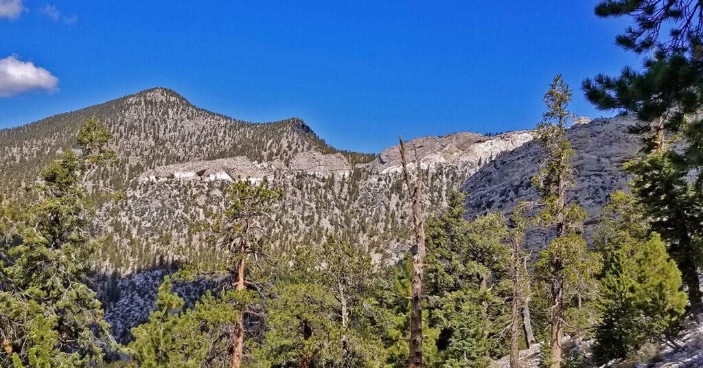
McFarland Peak from Bristlecone Pine Trailhead | Lee Canyon, Spring Mountains, Nevada

The route to the base of McFarland Peak via the Bristlecone Pine and Bonanza Trails is a true show stopper! Most of the route winds through an ancient pristine Bristlecone Pine forest. As if that were not enough, all along the way there are spectacular views including Mummy Mountain, the North Ridge of Kyle Canyon from Mummy Mountain to Lee Peak and then on to the summit of Charleston Peak, the Sisters Peaks bordering Lee Canyon, Pahrump Valley and Telescope Peak in the Panamint Range on the far side of Death Valley as a faint high point in the background and of course the full spectacular Western side of McFarland Peak with its sheer majestic cliffs. Route Details: 15 mi RT/ Approx. 8,690 > 9,600ft; **Excellent Trail** Click image or title above for more…
Macks Peak | Mt Charleston Wilderness | Spring Mountains, Nevada
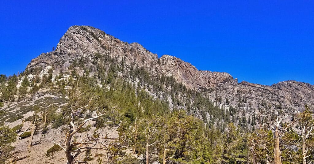
Macks Peak is located in the Spring Mountains near Las Vegas, Nevada. There are 2 summits: SE summit, elevation 9,924ft and NW summit, elevation 10,036ft with a long ridgeline between. Once you rise along the approach ridge over about 8,500ft the wilderness assumes a beautiful, untouched alpine feel with various wildflowers, pine forests and eventually Bristlecone Pines. There are spectacular 360 degree views all along the approach ridge including the Sisters peaks, Charleston Peak, Lee Peak and Mummy Mountain along with the high ridgeline between, Angel Peak, the Northern part of the Las Vegas Valley, Gass Peak and the Sheep Range. Route details: 14 mi RT/ Approx. 7,000 > 9,500ft; **Road, Trail, Wilderness** Click image or title above for more…
Lee Peak from Lee Canyon | Mt Charleston Wilderness | Spring Mountains, Nevada

This adventure in process will work out the most direct route possible from to Lee Peak from Lee Canyon. View the initial exploration which begins at the Upper Bristlecone Pine Trailhead. From there, the route soon diverges left and ascends to a ski run, taking the ski run to its upper limit, then continuing to navigate upward through canyons and ridges toward Lee Peak. There’s a surprise appearance of wild horses in one of the ski runs. There’s a lot yet to be worked out with this very experimental route to the summit, and the possibility of circling around the base of Lee Peak and ascending from the South. The goal is a class 3 ascent, possibly through a rather remote untested area. Route details: 16 miles RT/ Approx 8,300 > 11,200ft **Some Trails, Ski Run, Mostly Wilderness** Click image or title above for more…
Foxtail Canyon Springs, Foxtail Girl Scouts Camp and Beyond, Spring Mountains, Nevada

These magnificent and little-known springs are located in Foxtail Canyon off of Lee Canyon in the Spring Mountains, Nevada. The springs flow or drip year-round into a 6-ft high, 75ft long cave at the base of a 30-40ft high cliff in Foxtail Canyon. As with other springs in the Spring Mountains, the springs are surrounded by lush vegetation. A long wide shelf spans the front of the cave from which there is a spectacular view down Foxtail Canyon into Lee Canyon. Above the cliff cave one can continue upward toward Mummy Mountain and the North Ridge of Kyle Canyon. 5 mi / Approx. 8,450 > 9,800ft; **Faint Trail** Click image or title above for more…
Bristlecone Pine Trail in Mt. Charleston Wilderness, Nevada

The Bristlecone Pine Trail in the Mt. Charleston Wilderness is a delightful 6-mile loop that gives the hiker or runner an experience of rising up to the bristlecone pine zone without having to ascend steep inclines or engage in a long-distance hike or run. It’s actually one of the first Spring Mountains mountain adventures a person might experience as they are conditioning for higher altitudes and heavier exertion. Route details: 6.8 mi / Approx. 8,690 > 9,400ft; **Excellent Trail** Click image or title above for more…
Bonanza Peak from Bristlecone Pine Trail | Lee Canyon | Spring Mountains, Nevada
I’ve never been on a more beautiful trail than the Bonanza Trail. The majestic Bristlecone Pines, artistic rock formations and spectacular views along with the solitude make this trail totally unique. Bonanza Peak elevation is 10,397ft. Though it is just 2000ft above the elevation of the Lower Bristlecone Pine Trailhead where this adventure begins there is an additional 1,700ft descent and re-ascent just before the summit, and before that, the Bonanza trail descends and re-ascends 300ft 2-3 times. So, the total ascent for this adventure is close to 4,500ft and the distance is at least 26 miles. Route details: 26 mi RT/ Approx. 8,483 > 10,397ft; **Excellent Trails** Click image or title above for more…
Mummy Mt Grand Crossing | Foxtail Canyon > Mummy Summit > Deer Creek Road | Spring Mountains, Nevada

This adventure begins at the Foxtail Picnic Area in Lee Canyon, summits Mummy Mountain, descends the Eastern cliffs and Cougar Ridge Trail, then takes Deer Creek and Lee Canyon Roads back to the Foxtail Picnic Area. I recommend a base conditioning level of at least 5-miles running 4 times weekly along with one day topping 10-15 miles. Be altitude conditioned at the 11,000ft level, have wilderness navigation experience and ability to navigate very steep, long avalanche slopes. Route details: 18 mi RT/ Approx. 8,000 > 11,520ft; **Mostly Wilderness** Click image or title above for more…
Lee Peak from Lee Canyon | Mt Charleston Wilderness | Spring Mountains, Nevada

In the course of this amazing adventure you will pass through relatively untouched wilderness between Upper Lee Meadows on Lee Canyon Road and the summit of Lee Peak towering above Lee Canyon. The elevation gain is about 3,500 feet. You will need good wilderness navigation skills and the ability to navigate steep avalanche slopes. Otherwise, the entire adventure is pretty easy class 2 climbing skills (use of hands not needed). Route details: 18 mi RT/ Approx. 8,000 > 11,200ft; **Some Trail, Mostly Wilderness** Click image or title above for more…