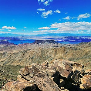
Mt. Wilson Arizona Summit | Lake Mead National Recreation Area, Arizona
Overview | Mt. Wilson Arizona Summit | Lake Mead National Recreation Area, Arizona
Adventure Slide Guide to Appear Here Summer, 2024
Arizona Mt. Wilson as a Spectacular, Unique, Stand-Alone Summit
You may be familiar with Mt. Wilson towering above Red Rock Canyon in Nevada’s Rainbow Mountains. But did you know that there is another Mt. Wilson…in Arizona? This other Mt. Wilson is closely surrounded on three sides by Lake Mead National Recreation Area. As a tall stand-along high point, the Arizona Mt. Wilson summit at 5,713ft elevation serves as one of the most outstanding vantage points to view the Lake Mead National Recreation Area and the surrounding region from the Mt. Charleston Wilderness in Nevada to the Virgin Mountains to the Colorado River basin and many additional famous reference points. In fact, so distinctive is the summit of Mt. Wilson that it is used as a reference point for commercial aircraft in their final approach to Harry Reid International Airport in Las Vegas!
Route to the Summit of Arizona Mt. Wilson
The route to the summit of Mt. Wilson with its spectacular views begins at the Arizona Hot Springs Trailhead on Hwy 93 South of Hoover Dam (enlarge the map on this page). Instead of heading down toward Arizona Hot Springs near the edge of the Colorado River, head in the exact opposite direction up the unpaved Horse Thief Canyon Road. If you’re driving, be sure to have a very rugged high-centered vehicle! At the upper end of Horse Thief Canyon Road, continue up the canyon to a beautiful spring and take a right into an adjoining canyon. Continue up that canyon, eventually ascending to a saddle on the ridgeline at the upper end of the canyon. Take a right on that ridgeline and ascend that ridgeline all the way to the summit of Mt. Wilson!
Difficulty Level of the Arizona Mt. Wilson Adventure Route
This entire adventure is an easy class 2 ascent, but with some steep, loose rock stretches. The beautiful desert flowers we saw on this April adventure, along with lizards and geological formations are featured in this video. A surprised rattlesnake evaded our cameras!
Best Time of Year to Summit Arizona Mt. Wilson
The best time of year for this adventure is Spring and Fall. Winter can occasionally bring icy conditions on the boulders approaching the summit of Mt. Wilson and Summer often brings temperatures approaching and exceeding 100 degrees!
Route Starting Point Directions | Mt. Wilson Arizona Summit | Lake Mead National Recreation Area, Arizona
The adventure begins at the Arizona Hot Springs trailhead on Arizona Highway 93, 4 miles South of the Nevada/Arizona border. Instead of crossing under the highway as you would if headed toward Arizona Hot Springs and Liberty Bell Arch, travel in the opposite direction up Horse Thief Canyon Road, the unpaved road that branches off from the trailhead parking area.
Narrative Guide | Mt. Wilson Arizona Summit | Lake Mead National Recreation Area, Arizona
Beginning on Horse Thief Canyon Road
Horse Thief Canyon Road is well marked with a road sign visible from the Arizona Hot Springs trailhead area. In the past I’ve walked/ran the road. Driving the road for the first time today was like driving up a canyon wash. Hold your breath in more than one place. The road is distinct and near the upper end winds around to the right ending at a box canyon, blocked by a vertical dry fall. It’s not hard to imagine the canyon corralled by horse thieves as a place to keep their stolen horses.
Horse Thief Canyon to Horse Thief Canyon Spring
Hiking begins here, by taking a bypass trail to your left circling up and around the dry fall before descending into the upper canyon. Continue up the canyon, ascending some beautiful limestone terraces, surrounded by tall canyon walls artistically populated by cactus gardens. Further up the canyon you may see water cascading over the limestone terraces, indicating you’re approaching the lush Horse Thief Canyon Springs. Suddenly, there are willows, tall grasses, and singing birds in the beautiful marsh area. Contrast this scene with the stark dry desert terrain surrounding the spring.
Adjoining Canyon to It’s Upper End Saddle
Continue up through Horse Thief Canyon Spring and at the spring’s upper end, take a right into an adjoining canyon. Now you’re again in a stark desert area populated by cacti and sage brush. Though there are ridges branching upward to the left (which I have taken on previous adventures), continue up the canyon as it winds around, eventually ending in a high ridgeline saddle.
Initial Ridgeline Ascent Toward Mt. Wilson
Ascend to the saddle and take a left on its ridgeline. Now you’re on the ridgeline that will take you all the way to the summit of Mt. Wilson! The most challenging stretch of this ridgeline is straight ahead as you wind around boulders and ascend a steep loose rock slope to the higher level above.
Spectacular Viewpoints Along the Way!
Once you’ve attained the higher level continue upward as the ridgeline veers slightly to the left, continuing upward toward Mt. Wilson’s pointed summit in the distance. There are a number of spectacular vantage points along the ridgeline where you can view Lake Mead, the Las Vegas Strip framed by the Mt. Charleston Wilderness in the background. At points you’ll be looking down upon Hoover Dam, the rugged Colorado River Gorge and the bridge you crossed earlier between Nevada and Arizona. The sculpted rock formations on the ridgeline create an incredible foreground to your photos.
Sculpted Rock Formations On the Mt. Wilson Summit Approach
As you approach Mt. Wilson’s summit, the sculpted rock formations become more distinct and unique. Watch for a formation reminiscent of the statues on Easter Island!
360-Degree Views from Mt. Wilson’s Summit!
Standing on the summit, observe the commercial airliners passing above like clockwork…so close you can read their painted logos. They’re receiving guidance signals from a communications tower you can see on a ridge across Horse Thief Canyon. Enjoy the spectacular 360-degree views from the summit before returning by the same route, this time nearly 100% downhill all the way back to the parking area in Horse Thief Canyon.