Mummy Mountain Forehead | Mt Charleston Wilderness, Nevada

Starting from Lee Canyon Road, pass through ancient bristlecone pine forests along majestic limestone cliffs to visit one of the distinctive features that makes this mountain look like a mummy! The best time of year for this adventure is Summer. Click the image or title above for details.
Mummy Mountain Head from Lee Canyon Rd | Additional Approaches | Spring Mountains, Nevada

Once you’ve summited Mummy’s Head from Lee Canyon Road, there are a number of options. You can precede to Mummy’s Nose and Chin, attempt an ascent to Mummy’s Summit or circle around down to the Deer Creek Road or Foxtail area. All these options present challenging climbs. Route details: 10 mi RT/ Approx. 8,000 > 11,535ft; **Some unmarked trails and cairns, mostly wilderness** Click image or title above for more…
Mummy Mountain Summit from Lee Canyon | Mt Charleston Wilderness | Spring Mountains, Nevada

This adventure takes you up a canyon wash on the far Northwestern edge of Mummy Mountain. Though the wash is filled with boulders, branches and tree trunks, one can find a pretty easy class 2 stairway dramatically ascending upward through unique climate and plant life zones from the beginning of the adventure at 8,000ft on Lee Canyon Road to the 11,532ft summit of Mummy Mountain. Of course, expect a few of Mummy Mountain’s signature avalanche slopes. There are spectacular views all the way up… Route details: 10 mi RT/ Approx. 8,000 > 11,535ft; **Mostly Wilderness** Click image or title above for more…
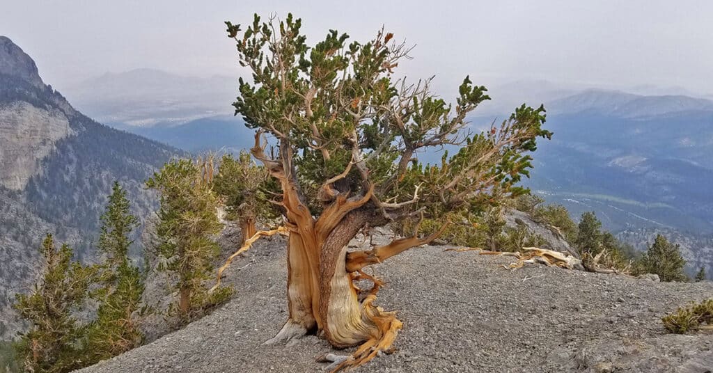
Mummys Head from Lee Canyon Rd | Mt. Charleston Wilderness | Spring Mountains, Nevada

This is the most direct approach route to Mummy’s Head. It begins from a wide parking area on the right side (West) of Lee Canyon Road to summit Mummy’s Head by unmarked trails and wilderness. Route details: 10 mi RT/ Approx. 8,000 > 11,535ft; **Mostly Wilderness** Click image or title above for more…
Mummy Mt Grand Crossing | Foxtail Canyon > Mummy Summit > Deer Creek Road | Spring Mountains, Nevada

This adventure begins at the Foxtail Picnic Area in Lee Canyon, summits Mummy Mountain, descends the Eastern cliffs and Cougar Ridge Trail, then takes Deer Creek and Lee Canyon Roads back to the Foxtail Picnic Area. I recommend a base conditioning level of at least 5-miles running 4 times weekly along with one day topping 10-15 miles. Be altitude conditioned at the 11,000ft level, have wilderness navigation experience and ability to navigate very steep, long avalanche slopes. Route details: 18 mi RT/ Approx. 8,000 > 11,520ft; **Mostly Wilderness** Click image or title above for more…
Mummy Mountain Toe, Mt. Charleston Wilderness | Spring Mountains, Nevada

The Southwestern edge of Mummy Mountain forms a sheer cliff over 1,000ft in height on 3 sides and that cliff is referred to as Mummy’s Toe. Mummy’s Toe, though unknown by most hikers in the Mt. Charleston Wilderness, is a awesome destination hike in itself. Like the bow of a ship the 270 degree view to the South, East and North is unmatched. Route details: 14 mi / Approx. 8,439 > 11,000ft **Some Trail > Some Wilderness** Click image or title above for more…
Mummy Springs Loop | Cougar Ridge Trail | Mt. Charleston Wilderness, Nevada

Mummy Springs Loop is an awesome hiking or trail running workout! You’ll park at the North Loop Trailhead, take a short 1/8th-mile stretch down Deer Creek Road to Cougar Ridge Trail Road, ascend that road and trail about 2000 feet straight up the healthy incline of Cougar Ridge Trail, take a left at Mummy Springs Trail, Cross beneath Mummy Springs, head to Raintree then take a left down the North Loop Trail back to the North Loop Trailhead. Route details: 10 mi / Approx. 8,439 > 10,023ft **Excellent Trail** Click image or title above for more…
Mummy Mountain South Eastern Approach in Mt. Charleston Wilderness, Nevada

Mummy Mountain Eastern approach is a fascinating journey including well established trails, traverse across largely untouched wilderness area, ascent up steep avalanche slopes, traverse along the edge of cliffs along with a brief ascent up a 10ft vertical rock wall with a 100ft drop-off below. Route details: 16 mi / Approx. 8,439 > 11,530ft **Some Trail > Mostly Wilderness** Click image or title above for more…
Mummy Mountain NNE, Mt. Charleston Wilderness, Nevada

This adventure extends the exploration of the East side of Mummy Mountain through the wilderness to a viewpoint overlooking the Northern area of Mummy Mountain. From this pretty amazing viewpoint one can see the entire East side of Mummy Mountain with all the Eastern cliff approaches, look to the South to view Mummy’s Toe along with its full approach, and to the North, a unique view of Mummy’s head along with potential routes that might take one around the Northern side and on up to Mummy Mountain summit. Route details: 14 mi / Approx. 8,439 > 11,151ft **Some Trail > Mostly Wilderness** Click image or title above for more…
Mummy Mountain Northern Wilderness Overlook & Exotic Ancient Bristlecone Pines
This adventure is a brief extension of the Mummy Mountain NNE adventure. This adventure moves to the very edge of the NNE area where the only way forward is a pretty dramatic descent either to the Lee Canyon area or to potential routes allowing re-ascent of the Mummy Northern cliff area just below Mummy’s Head – more accurately, Mummy’s neck. In addition, this adventure also documents some of the amazing ancient Bristlecone Pine trees in the largely untouched Mummy Mountain Northern area. Route details: 14 mi / Approx. 8,439 > 11,000ft **Some Trail > Mostly Wilderness** Click image or title above for more…