Fossil Ridge Far East, Desert National Wildlife Refuge, Nevada

Fossil Ridge is located in the Desert National Wildlife Refuge of Nevada. In this adventure, begin to explore the far Eastern end of Fossil Ridge, which extends far beyond the more familiar Western end. There may even be a faint trail spanning the summit of Fossil Ridge. Route Details: 16 Miles RT from DNWR HQ – 4WD Road, Wilderness; Some Class 3 Climbing. Climb Click image or title above for more…
02 Visitor Center | Desert National Wildlife Refuge, Nevada

The Desert National Wildlife Refuge just North of Las Vegas Was Created to Protect Nevada’s Bighorn Sheep. The Visitor Center Has Well Designed Interpretive Displays, a Desert Oasis Walkway and is Staffed with Helpful Experts. The DNWR is the largest wildlife refuge in the lower 48 states and has as its main feature the massive Sheep Range.
Fossil Ridge North | Sheep Range, Nevada

The Northern side of Fossil Ridge is a pretty amazing place. There are fossils embedded in the rocks all along the base of the ridge. These can be seen even without climbing the ridge, especially in the darker rocks beginning in Yucca Gap which skirts the North side of Fossil Ridge. The fossils only get more varied and abundant as you select a spot along Fossil Ridge, ascend and wander around. The scene expands into an upper valley with the largest Joshua Tree forest I’ve ever seen (officially the “Yucca Forest”), extending beyond the Southern tip of the Sheep Range on one side and along the Northern side of Fossil Ridge on the other. Route Details: 12 Miles RT from DNWR HQ **4WD Road** Click image or title above for more…
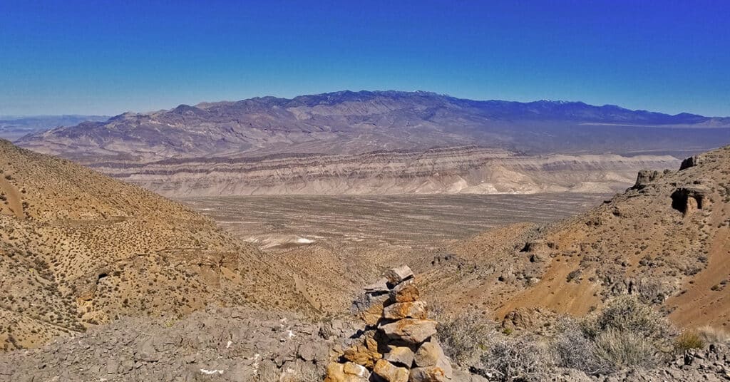
Fossil Ridge End to End | Sheep Range | Desert National Wildlife Refuge, Nevada

The summit of Fossil Ridge is like a scene from The Land That Time Forgot. I don’t think many humans walk the summit of Fossil Ridge…I saw absolutely no sign of human passage…no rock cairns, no camp fires, no foot prints…nothing. Yet, the summit is around a half mile in length and at least 200ft wide. It’s a total, unique world up there with its own Joshua Trees and other vegetation along with some sparse but obvious fossils embedded in the darker rocks. Either the ancient seas here were 2000-4000ft deep or the seas were more shallow and the land has risen. Probably a little of both. I felt like the only human to have ever stood on that place. Route details: Approx. 15 Miles (RT from DNWR HQ); Some Road, Some Wilderness, Cl 3 Climb Click image or title above for more…
Cow Camp Road | Sheep Range | Desert National Wildlife Refuge, Nevada

Cow Camp Road is a branch off of Alamo Road (at the 12-mile point) in the Desert National Wildlife Refuge in Southern Nevada. On the Northern tip of the Sheep Range the 5.7-mile long Cow Camp Road provides a great approach to the Sheep Peak trailhead, Sheep Peak being the 2nd highest point in the Sheep Range at 9750ft. The trailhead elevation is about 5,750ft. In addition there are camping areas in and beyond the canyon pass on Cow Camp Road and beautiful views of the Northern area of the Sheep Range. I took the trip up Alamo Road on a mountain bike, then ascended Cow Camp Road on foot so there are ample 360-degree video views along the way. Route details: 28 Miles RT from DNWR HQ – 4WD Roads Click image or title above for more…
Lower Mormon Well Road, Sheep Range, Nevada

Travel the lower 15-mile stretch of Mormon Well Road from the Desert National Wildlife Refuge headquarters on Corn Creek Road to the intersection of Mormon Well Road and Pine Nut Road by mountain bike. Points of interest are the intersection of Gass Peak Road at the 4-mile point; Yucca Gap between the Southern tip of the Sheep Range and Fossil Ridge at the 5-mile point; and the incredibly massive Yucca Tree Forest spanning the entire Sheep Range valley beyond Yucca Gap. Route details: 30 Miles RT; **4WD Road** Click image or title above for more…
Lower Alamo Road | Sheep Range | Desert National Wildlife Refuge, Nevada

Travel from the Desert National Wildlife Refuge headquarters to the intersection of Alamo Road and Cow Camp Road. This 12-mile stretch skirts the entire West side of the Sheep Range from South to North, and then begins to circle around the Northern tip of the Sheep Range to access trailheads to Sheep Peak and Hayford Peak. The stretch along lower Alamo Road offers awesome views of the entire West and Northwest side of the Sheep Range, Gass Peak, the La Madre Mountains Wilderness and the Mt. Charleston Wilderness including especially Mummy Mountain, Fletcher Peak and Griffith Peak. Otherwise, it’s a pretty barren, windswept stretch of desert. The unpaved 4WD road is pretty firm for a mountain bike but does have a few stretches of deeper gravel and many washboard sections which can scramble the brain on the downhill return! Route details: 24 Miles RT – **4WD Road**. Click image or title above for more…
01 Sheep Range North of Las Vegas, Nevada | Overview
The Sheep Range is located in the Desert National Wildlife Refuge just North of Las Vegas, Nevada. The refuge was named for its purpose to protect the bighorn sheep population and is the largest wildlife refuge in the lower 48 States. The motor vehicle entrance to the Sheep Range is off Nevada Hwy 95 at Corn Creek Road. There is a beautiful interpretive center with a desert interpretive walkway and ample parking for about 30 vehicles. There is a 4WD road system entirely circling the Sheep Range with additional roads branching off to trailheads and camping areas. Just South of the Sheep Range sits Fossil Ridge, an ancient rocky ridgeline with Nautilus fossils aging near 450 million years old dating back to the era when there was just one continent on Earth, Pangea. Follow thumbnail images to view the details you will need to plan your adventures here. Click image or title above for more…