Overview | Fletcher Peak and Rain Tree | Mt. Charleston Wilderness | Spring Mountains, Nevada
Fletcher Peak, at 10,319ft Elevation is a substantial summit in itself were it not shadowed by the higher peaks in the
Spring Mountains. The video on this page gives altitude readings that are about 700ft low as my summit reading was 9,600ft. Just add 700ft to each altitude reading!
Directions to Start Point | Fletcher Peak and Rain Tree | Mt. Charleston Wilderness | Spring Mountains, Nevada
My beginning trailhead on this July 20th day was the
North Loop Trailhead on
Highway 158 Deer Creek Road between
Kyle Canyon and
Lee Canyon. To get to this point from
Las Vegas head North on
Hwy-95 taking a left at one of the last
Hwy-95 exits in the
Las Vegas area,
Kyle Canyon exit. Continue up
Kyle Canyon Road about 17 miles and a couple miles before
Charleston Village take a right on
Highway 158 toward
Lee Canyon. You’ll wind around the hillside to the left and as the road briefly levels off before descending toward
Lee Canyon, the
North Loop Trailhead will appear on the left. During the Summer months you may want to get there before 8am as the parking fills up pretty fast. Looking back toward Las Vegas, there’s a good view of
La Madre Mountain from the trailhead parking lot.
↓ Narrative Guide ↓
Narrative Guide | Fletcher Peak and Rain Tree | Mt. Charleston Wilderness | Spring Mountains, Nevada
Ascending to the First Plateau on the Way to Fletcher Peak
The trail ascends with a pretty healthy incline. I experienced about 1,800ft of ascent per hour. You begin ascending through a beautiful evergreen forest composed of
Ponderosa Pines and
Pinyon Pines giving way to
Bristlecone Pines by the time you’re about half way to
Fletcher Peak. There’s an awesome plateau about a mile up the trail giving the first great view of the Eastern approach side to
Mummy Mountain. In the video on this page we analyze that approach in detail. In the other direction, to the West you can see
La Madre Mountain,
Gass Peak, the
Desert National Wildlife Refuge, largest refuge in the lower 48 States, and the
Sheep Mountain Range.
Ascent to a High Ridge On the Way to Fletcher Peak
About 100-200ft beyond the plateau begins a series of 10-11 switchbacks as the trail rapidly ascends. Near the top of the switchbacks there’s a faint trail to the right that rises to a ridge from which there are awesome views of the East side of
Mummy Mountain (to the West) and
Fletcher Peak and beyond (better perspective of all points of interest you saw earlier from the lower plateau). You can also see a lower point of the
Fletcher Peak Trail 260ft below.
Griffith Peak and the South ridge of
Kyle Canyon also come into view.
Descending to Reconnect with the North Loop Trailhead and Fletcher Peak Trail Turnoff
After descending the ridge about an 8th of a mile the ridge trail reconnects with the main
North Loop Trail. In another 8th to a 4th of a mile you’ll see two tree trunks that had fallen across the trail, now sawn in half. The second of these is the place where you take a sharp left off the
North Loop Trail and onto the unmarked
Fletcher Peak Trail. Soon you’ll be at the point you saw a moment ago from the ridge 260ft above.
On to Fletcher Peak Summit
Continue along up and down a series of gentle hills until the trail begins to sharply rise up to the summit of
Fletcher Peak. You’ll see a small mound of rocks and a summit box. You made it! From the summit of
Fletcher Peak you can see
Harris Mountain,
Griffith Peak, the entire lower and upper
South ridge of Kyle Canyon,
Charleston Peak, the Western ridge of the canyon and
Lee Peak. Then there’s
Mummy Mountain’s Toe and an angled, not so good as before view of the
East side of Mummy. There are great views to the North and East including all the points of interest mentioned earlier, only from a higher perspective.
Descent Back to the North Loop Trail and Rain Tree
After descending
Fletcher Peak, turn left at the
North Loop Trail and continue about an 8th of a mile to
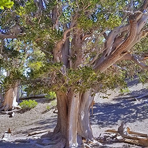
Rain Tree, a majestic 3000-year-old
bristlecone pine. It was a sapling in 1000 B.C. and could be around in another 3,000 years. Imagine the world history that has taken place in its lifetime, and the history that will take place in the next 3000 years in the life of this giant!
Route Choices from Rain Tree: Mummy Springs and Summit, Charleston Peak Summit, Charleston Village, North Loop Trailhead
At
Rain Tree you can take a left and descend a couple miles to the junction of the
Trail Canyon Trail, take a right there and head on up to
Lee Peak and
Charleston Peak; or, you can take a right at
Rain Tree and continue past
Mummy Springs and on up along the Eastern summit approach route and finally to
Mummy Mountain Summit. Or, you can turn around and head back to the
North Loop Trailhead…after rising a few hundred feet you begin the final descent a couple thousand feet to the trailhead.