Damsel Peak End-To-End | Brownstone Basin, Nevada
Ascend the SE slope of Damsel Peak, then traverse from the south to the North summit. Finally, return through the Brownstone Basin. Click the image or title above for details.
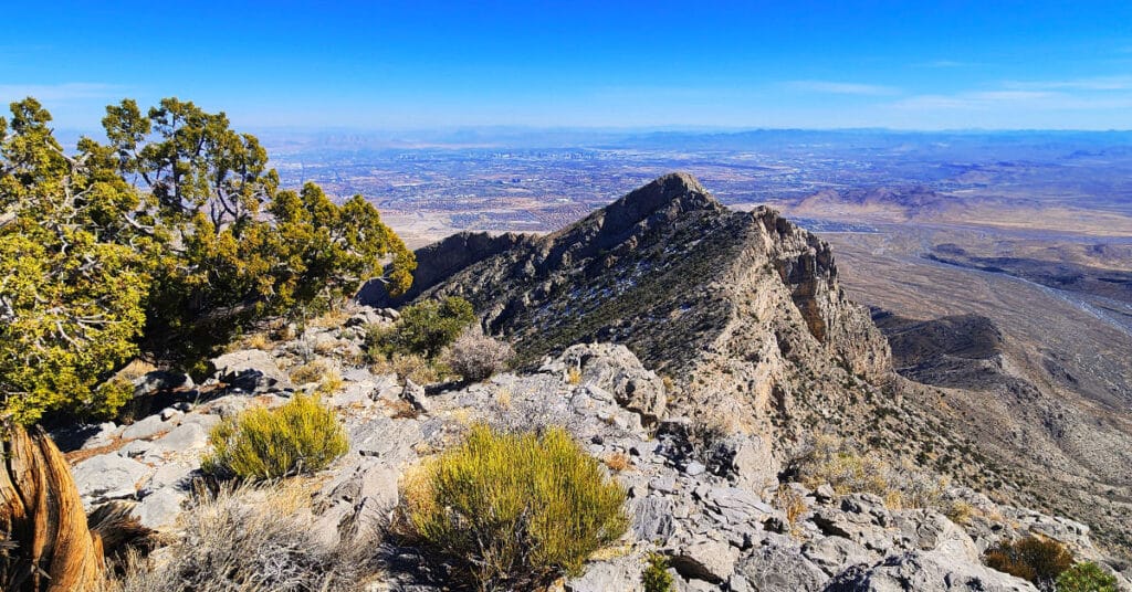
Gray Cap Ridge Brownstone Basin Loop | La Madre Mountains Wilderness, Nevada

Beginning at Gene’s Trailhead in the Calico Basin, traverse most of Gray Cap Ridgeline from the SE Summit, then return to the Calico Basin by way of the Brownstone Trail and Road. Best time of year for this adventure is Spring or Fall. Click the image or title above for all the details.
Brownstone Trail | Calico Basin | Brownstone Basin | La Madre Mountains Wilderness, Nevada

The Brownstone Trail adventure spans Nevada’s Calico Basin, Brownstone Basin and La Madre Mountains Wilderness. Along the way, there are spectacular views of the La Madre Mountains Ridgeline, Damsel Peak, the Las Vegas Valley and Strip and the Jurassic Era calico sandstone Gray Cap Ridge. Click the image or title above for more detail.
Damsel Peak Loop | Brownstone Basin, Nevada

This complete loop of Damsel Peak’s base in the Brownstone Basin, Nevada searches for previously unknown summit routes to the summit.
3 Basin Circuit | Red Rock Canyon, Nevada

Experience 3 incredible Southern Nevada wilderness areas in one great adventure. This circuit begins in the Calico Basin, rounds the South side of the Calico Hills, heads North to upper Red Rock Canyon, circles over to Brownstone Basin then finally descends to the starting point in Calico Basin. Click the image or title above for more details.
La Madre Mountain Eastern Approach from Red Rock Park, Nevada

The Eastern approach route will begin following the same path as the Southern approach route starting at the Sandstone Quarry parking area (Turtlehead Peak trailhead). From there head up Red Rock Wash and circle around the upper end of the Turtlehead Peak ridge system into Calico Basin, cross the upper Calico Basin, circle around the East end of the Keystone Trust and finally ascend the North side of La Madre Mountain.
It’s important to note that as with the other routes up La Madre Mountain, this route is quite the marathon and the most limiting factor will be enduring the distance and altitude gain. Image: Damsel Peak from La Madre Mt. East approach. Route description: 28 mi / 4306-8000ft; *Wilderness, No Trail* Click image or title above for more…
La Madre Mountain Southern Approach from Red Rock Canyon | La Madre Mountains Wilderness, Nevada

La Madre Mountain is 8,154ft in elevation. It is the highest central feature of the Keystone Thrust, the cliff system that spans the rear area of Red Rock Park in Nevada. The La Madre Mountain Southern approach, from a distance, looks impossible as you’re facing a sheer cliff wall between 1000 and 2000 feet high. However, as you approach the base of the cliff from Calico Basin it’s evident that there is a passage between the two peaks. The summit view is amazing featuring Las Vegas Valley with Lake Mead across and to the East, Gass Peak and the Sheep Range to the North, spectacular views of Mt. Charleston Wilderness to the East and the awesome total expanse of Red Rock Canyon National Conservation Area and Calico Basin to the Southwest. Route details: 22 mi / 4306-8000ft; *Wilderness, No Trail* Click image or title above for more…
Kraft Mountain – Gateway Canyon Loop | Calico Basin | Red Rock Canyon National Conservation Area, Nevada

On this day I intentionally set out to head up Gateway Canyon thinking it might be a short cut to Damsel Peak. Wrong! Between figuring out the best way to navigate 10-15 class 3 and class 3 barriers, I ate up so much time that I decided to just make a large loop out of Gateway Canyon, continuing all the way to Brownstone Basin at the base of Damsel Peak, and then taking Brownstone Basin down to a cross-over point back to Kraft Mountain. Many hikers have mistakenly taken this route thinking they are on the Kraft Mountain Loop. I made this very mistake on my first attempt to do the Kraft Mountain Loop! In fact, during today’s adventure, I redirected 2 groups of appreciative hikers back to the Kraft Mountain Loop. Here’s how that error happens… Route details: Approx . (12 mi.) | 3,700-5,400ft Elevation; **Some Trail, Mostly Wilderness** Click image or title above for more…
Damsel Peak Southern Approach Route from Calico Basin, Nevada

The Southern approach to the summit of Damsel Peak (aka Pincushion Mt) in Nevada begins at the trailhead parking area in Calico Basin, navigates to the South side of Damsel Peak, traverses to the North side, descends into Brownstone Basin then navigates back to the starting point in Calico Basin. Incredible views from the summit of Damsel Peak include almost all of the Las Vegas Valley, Brownstone and Calico Basins, Turtlehead Peak, the Calico Hills, Mt. Wilson, Rainbow Mountain, Juniper Peak, North Peak and Bridge Mountain and finally the huge expanse of the Keystone Thrust cliffs with La Madre Mountain as the high point. To the North one can see Gass Peak, the Sheep Range and Fossil Ridge. Route details: Approx 15 mi RT; **No Trails, Some Class 3 Climbing** Click image or title above for more…