La Madre Ridge East Base Circuit | La Madre Mountains Wilderness, Nevada

Explore the very Eastern edge of the La Madre Ridgeline. Cross from Kyle Canyon to the area above Little Red Rock. Discover a cool backcountry 4WD road. Explore an approach to the La Madre Eastern Saddle. Click the image or title above for details.
La Madre Ridgeline Eastern Grand Crossing Loop | La Madre Mountains Wilderness, Nevada

Cross a majestic 300ft high gateway between two worlds in Nevada’s La Madre Mountains Wilderness! Click the image or title above for details.
North Ridge Loop | La Madre Mountains Wilderness, Nevada

Explore the North side of the spectacular La Madre Mountains Ridgeline. Beginning at the Northeastern end of the La Madre Ridgeline, summit the North La Madre Ridge to 7,000ft just below the spectacular Devil’s Slide. Then, continue on the ridgeline descending to the La Madre Wilderness Campground to the Northwest. Finally, take lower approach roads back to your starting point at a trailhead parking area on Kyle Canyon Road just above the horse ranches. Discover key North La Madre Wilderness connections. Click the image or title above for details.
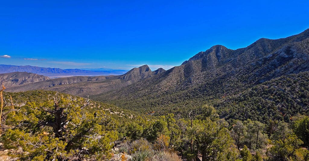
La Madre Ridgeline East Saddle | La Madre Mountains Wilderness, Nevada

The La Madre Ridgeline East Saddle in Nevada is the Grand Crossing Between Harris Springs Canyon and Little Red Rock. Click the image or title above for details.
La Madre East Ridge Approaches | La Madre Mountains Wilderness, Nevada

Explore Northern Approaches to the Magnificent, Pristine La Madre Mountains Eastern Ridgeline in Nevada. Click the image or title above for details.
Devils Slide | La Madre Mountains Wilderness, Nevada

Visit this massive ancient limestone see floor elevated to near vertical. It’s truly a great natural wonder! Click the image or title above for details.
La Madre Mt North Ridge | La Madre Mountains Wilderness, Nevada
Enjoy unique views of the Eastern stretch of the upper La Madre Ridgeline including La Madre Mountain and Devil’s Slide, Peak 7680, Fernande Peak, Peak 6826, the Eastern ridgeline saddle and East La Madre Peak. Click the image or title above for details.
La Madre Ridge East Loop | La Madre Mountains Wilderness, Nevada

Explore the East end of Nevada’s spectacular La Madre Ridgeline from La Madre Mountain to East La Madre Peak. Summit Peak 7680, Fernande Peak, Peak 6826 and East La Madre Peak along the way in the La Madre Mountains Wilderness, Nevada. Click the image or title above for details.
La Madre Ridgeline Grand Crossing | La Madre Mts. Wilderness & Red Rock Canyon NCA, Nevada

Navigate from Kyle Canyon Road to the summit of the La Madre Mountains Ridgeline, then descend to the entrance of Red Rock Canyon in Nevada. You’ll experience two unique worlds bordering one spectacular ridgeline during this 25-mile + wilderness adventure. Click the image or title above for details.
Kyle Canyon Grand Crossing Northern Half | La Madre Mountains Wilderness, Nevada

The Kyle Canyon Grand Crossing North is the Northern half of the larger Kyle Canyon Grand Crossing which begins at the intersection of Kyle Canyon and Harris Springs Roads, ascends to the El Bastardo Mountain area on the Keystone Thrust above Red Rock Canyon, then descends to Red Springs Desert Oasis in the Calico Basin. This Northern half of the adventure takes you to the saddle between Burnt Peak and El Bastardo Mountain on the Keystone Thrust Ridgeline, looks down to Red Rock Park and contemplates various routes into the park below before returning to the starting point on Kyle Canyon Road. Highlights include a walk though the beautiful La Madre Mountains Wilderness camping, navigating numerous rocky plateaus through the wilderness up the Burnt Peak approach ridge, exploring a section of the upper Keystone Thrust and seeing spectacular 360-degree views all along the route. Route details: 20 Miles + RT / 4500-7900ft; *Some Road, Mostly Wilderness* Click image or title above for more…