Dales Trail | Red Rock Canyon, Nevada

Dales Trail in Red Rock Canyon, Nevada, runs 2.2-miles along the Eastern base of the Rainbow Mountains between Pine Creek Canyon and Ice Box Canyon. At nearly every point along the way there are sweeping views of Red Rock Canyon. The trail skirts the Eastern Base of Bridge Mountain where one can observe potential routes to that hidden forest just below and to the East of Bridge Mountain’s summit block. The best time of year to hike Dales Trail is mid-Fall through mid-Spring. Click the image or title above to learn more…
SMYC Trail | Red Rock Canyon, Nevada

The SMYC Trail is a beautiful, easy 2-mile trail running along the base of the Rainbow Mountains, Nevada, between Willow Spring and Ice Box Canyon. Two high points afford spectacular views of Red Rock Canyon and surroundings. This is the Northernmost of a series of trails running along the Eastern base of the Rainbow Mountains in Red Rock Canyon between Willow Spring and Oak Creek Canyon. Click on the image or title above for images, a video and more details.
Ash Canyon to Calico Tanks | Calico Basin, Nevada

Beginning at the Kraft Mountain Trailhead in Calico Basin, ascend to the summit of Ash Canyon on the Ash Canyon Trail. Descending from Ash Canyon Summit connect with the Rattlesnake Trail and continue to the Calico Tanks Trail. After visiting Calico Tanks return to the Rattlesnake Trail. Ascend to the summit of that trail then descend into Gateway Canyon in the Calico Basin. Ascend Hell Hill Trail on Kraft Mountain to Pink Goblin Pass and finally descend to your starting point at the Kraft Mountain Trailhead. Experience spectacular views of 4 major wilderness areas and much more. Route Details: Approximately 10 miles RT on some fairly good trails and some unmarked sketchy trails. Best time for this adventure: Mid Fall through Mid Spring.
Ice Box Canyon | Red Rock Canyon National Conservation Area, Nevada

Ice Box Canyon, located on the Eastern side of the Rainbow Mountains between Willow Spring and Pine Creek Canyon is one of the most popular hikes in Red Rock Canyon. The brief 2.2-mile hike introduces the beauty and challenge of traversing the brush, boulders, ledges and streams in the canyons on the Eastern side of the Nevada’s Rainbow Mountains. This is a great 2nd canyon experience if you’ve never navigated such terrain. Easier, as a first experience is Lost Creek Canyon to the North. More difficult are Pine Creek, Oak Creek and First Creek Canyons to the South.
Canyons & Caves | Blue Diamond Hill | Red Rock Canyon, Nevada
Red Rock Canyon Keystone Visitor Guide Southern Nevada Conservancy Birding Guide Canyons & Caves | Blue Diamond Hill | Red Rock Canyon, Nevada Red Rock Canyon Website Area Satellite View North Satellite View South Satellite View Adventure Video Will Appear Here Overview | Canyons & Caves | Blue Diamond Hill | Red Rock Canyon, Nevada […]
Western Trails and Ridges | Blue Diamond Hill, Nevada

4.5-million-year-old fossils everywhere along this route! These Western trails on Blue Diamond Hill include Fossil Ridge, First Finger, Second Finger, Cat in the Hat and Bunny Trail. Spectacular rock formations on Kibbles ‘N Bits Trail. Great views of Cowboy Canyon and Echo Canyon. Great views of Cowboy Canyon and Echo Canyon. Distant panoramas include The Rainbow Mountains, Red Rock Canyon and the cliffs of the Keystone Thrust in the La Madre Mountains Wilderness. Route Details: About 6-8 miles, multiple times ascending Blue Diamond Hill, good trails. Best time of year: Mid Fall through mid-Spring. Click image or title above for more…
Western Outer Circuit | Blue Diamond Hill, Nevada

This is a circuit of the Western region of Blue Diamond Hill in Red Rock Canyon National Conservation Area, Nevada. The adventure starts at the Fossil Canyon Trailhead and takes a large counterclockwise circuit around Blue Diamond Hill. There are 2 high points on this route with exceptional views and the finish stretch through a beautiful canyon. The first great view is from the summit of a ridgeline West of Blue Diamond Hill. Next is the best 360-degree view on the East Ridge of Blue Diamond Hill. End with a descent through Skull Canyon on the Bob Gnarly Trail.
Eastern Outer Circuit | Blue Diamond Hill, Nevada
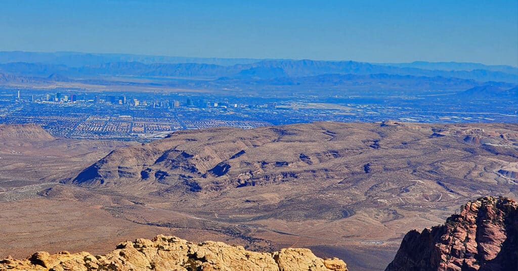
Blue Diamond Hill, on the South end of Red Rock Canyon in Nevada has a great network of multi-use trails including hiking, running, mountain biking and equestrian. We make a wide Eastern outer circuit of the trail system as an initial introduction. The spectacular 360-degree views from Blue Diamond Hill include Red Rock Canyon, the La Madre Mountains, Rainbow Mountains, Las Vegas Valley and much more! Click the image to view this adventure.
01 Blue Diamond Hill, Nevada | Overview

Blue Diamond Hill in Red Rock Canyon, Nevada, features a network of multi-use trails including hiking, running, mountain biking and equestrian. The trails offer various challenge levels, mostly in the class 1-3 climbing categories. However, there are class 4-5 rock climbing possibilities. Late Spring through early Fall. Follow thumbnail images to view the details you will need to plan your adventures here. Click image or title above for more…
Grand Circle Loop | Red Rock Canyon, Nevada

The Grand Circle Loop is and 11.3-mile trail that serves as a great overview of Red Rock Canyon and its surrounding wilderness areas including The Rainbow Mountain Wilderness and The La Madre Mountains Wilderness. Learn about the access points to these great wilderness areas and receive insight on wilderness navigation and strategy.