CIA Plane Crash in 1952 | Panamint Mountains | Death Valley, CA

Explore the crash site of a Cold War Era CIA Air Force SA-16 Albatross plane that crashed into the side of a steep slope in Death Valley, CA’s Panamint Mountains near Towne Pass on the night of January 24, 1952. Click the image or title above for details.
Furnace Creek Visitor Center | Death Valley, California

Use the Furnace Creek Visitor Center as your major staging area for adventures in Death Valley, California. It’s an important starting point for your experience of Death Valley. Find expert park ranger help at the front desk, beautiful interpretive displays, documentary movies, nightly ranger talks, ranger-guided walks, junior ranger programs, book and souvenir store and restroom facilities.
Death Valley Crossing | Death Valley National Park, California

What’s out there in the middle of Death Valley? People want to know first hand. Case in point:: The constant procession of Badwater visitors walking out into the desert as far as they can go during their visit. Death Valley draws you in, but nearly everyone turns around after just a quarter mile. See what it’s like to go from Badwater to the very middle of Death Valley and then a little beyond. What will you experience? What do you need to know?
Mesquite Grove | Furnace Creek | Death Valley National Park, California

Mesquite Grove in Death Valley National Park, California, is a huge crescent-shaped grove of desert mesquite trees stretching from the North side of Furnace Creek to the South side of Golden Canyon. The grove is so huge that it is visible from the distant summits of Wildrose Peak and Telescope Peak in the Panamint Mountains across Death Valley. Mesquite Grove, often overlooked, contains hidden wonders and is worth some exploration.
Wildrose Peak | Death Valley, California

Wildrose Peak is an 8.4 mile round trip trail beginning at the Wildrose Charcoal Kilns in Death Valley National Park, California. Ascending the excellent trail from the Wildrose Charcoal Kilns at 6,800ft elevation to the summit of Wildrose Peak at 9,064ft elevation, your total elevation gain is 2,264ft. Views at points along the trail and definitely from the summit are spectacular including the expanse of Death Valley almost directly below from Badwater to Furnace Creek and further in both directions with the Funeral Mountains as a backdrop. It’s a Grand Canyon level view! 8.4 Miles RT, 6,800 > 9,064ft **Excellent Trail** Click image or title above for more…
Wildrose Charcoal Kilns | Death Valley, California

The Death Valley Wildrose Charcoal Kilns, located on Charcoal Kiln Road near Telescope Peak in the Panamint Mountain Range are perhaps the best preserved Charcoal Kilns on earth. Built in 1877 to create charcoal used to smelt lead and silver in the Modock Mines about 25 miles West in the Argus Range, the Wildrose Charcoal Kilns were only used for 2 years. Click image or title above for more…
Telescope Peak Summit from Charcoal Kilns | Death Valley, California

Telescope Peak, on the highest ridge of the Panamint Mountain Range bordering the West side of Death Valley is as close as you can get to experiencing the entire valley in one adventure. The feeling is purely magical as you traverse a ridge on top of the world, looking straight from that 11,049ft elevation down to Badwater, lowest point in the Western hemisphere at -282ft. Route details: 19 mi Roads, Trails (mostly), Wilderness
6800ft > 11,043ft **Mostly Excellent Trails** Click image or title above for more…
Skidoo Ghost Town | Death Valley National Park, California

Skidoo Ghost Town & Mill, located near Emigrant Canyon in the Panamint mountain range above Death Valley, California, is an old California gold rush ghost town approachable by 4WD vehicles on a 9-mile unpaved road. The hills around Skidoo Ghost Town & Mill have around 1,000 abandoned mines along with the remains of iron machinery, wooden cabins, old rusting cars and other odds and ends from the mining era. The largest, most impressive remaining structure is the Skidoo Stamp Mill used to extract gold from raw ore. Route details: 18 Miles RT; 5000 > 5700ft **Fair Unpaved Road** Click image or title above for more…
Mesquite Dunes at Sunrise | Death Valley National Park, California

The Mesquite Sand Dunes turn every shade of color from white to golden during the hours of sunrise and sunset. But to witness the best display, you’ll need to wander into or out of the midst of the Mesquite Dunes in the dark, either before sunrise or after sunset. And during the time of pitch darkness, you’re either going to risk meeting up with a sidewinder rattlesnake during the warmer months from mid Spring through mid Fall, or getting very cold during the colder months from mid Fall through mid Spring. Route Details: Approx. 1.5 Miles RT; 100 – 200ft Elevation Gain **Wander Among the Dunes** Click image or title above for more…
Mosaic Canyon | Death Valley National Park, California
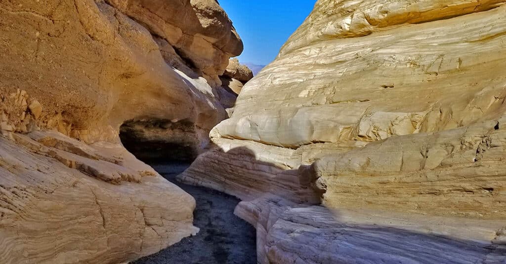
Though Mosaic Canyon is not a true slot canyon, there are some similarities. The action of water over tens of thousands of years has cut through and polished the solid rock walls into a surface resembling fine marble. Scenes of polished rock recall images of what you’d like to see in the ultimate elaborate marble bathroom or natural swimming pool. In places, there are large polished walls of composite rock forming countless wonderful unique mosaic patterns. Route details: Approx. 2-4 Miles RT; Approx. 900 > 2,000ft **Good Canyon Trail** Click image or title above for more…