Overview | East La Madre Peak | La Madre Mountains Wilderness, Nevada
Where is East La Madre Peak?
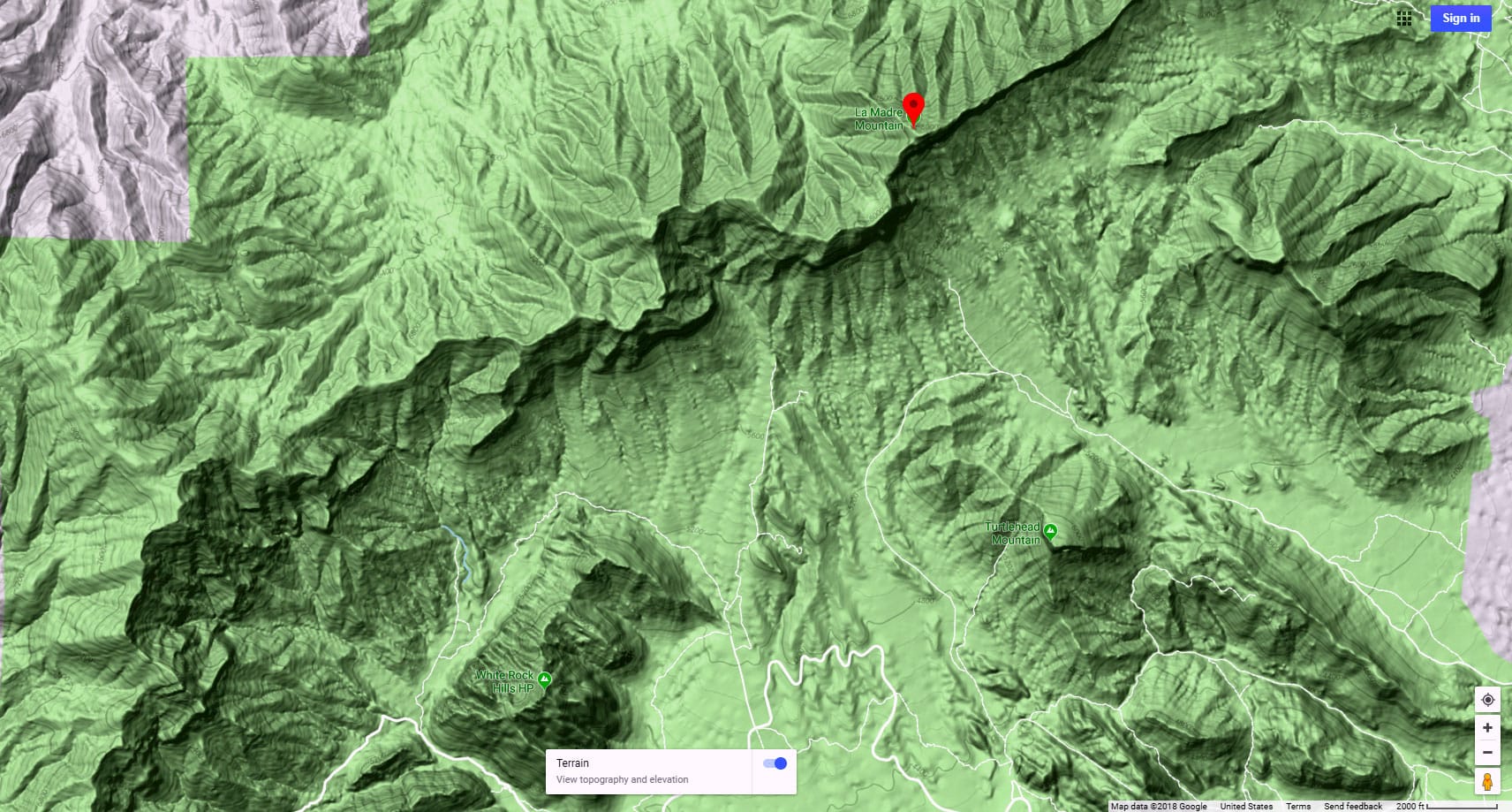
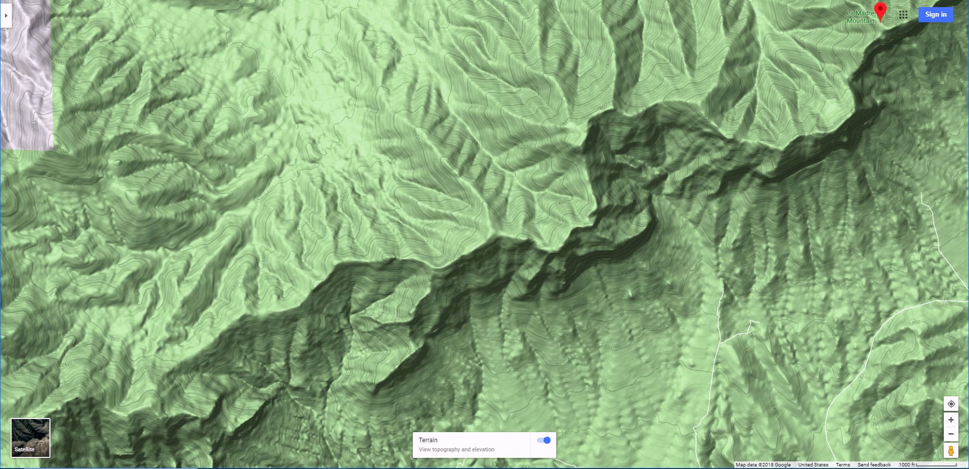
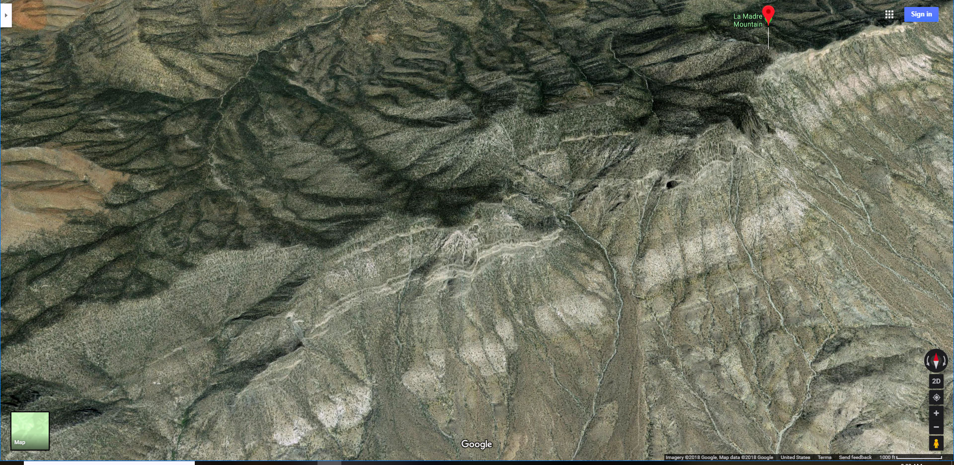
East La Madre Peak, aka “Little La Madre” (elevation 7,033ft) is located just East of La Madre Mountain, the highest point in the La Madre Mountains Wilderness of Nevada. It’s at the East edge of the La Madre Mountains Ridgeline and overlooks Brownstone Basin to the South, Kyle Canyon to the North and the Las Vegas Metro Area to the East. In fact, the route up the ridgeline to East La Madre Peak offers one of the most spectacular views of the Las Vegas Metro area.
Two Great Southern Nevada Ridgelines
The impressive La Madre Mountains Ridgeline, stretches from the Western edge of Las Vegas to the Eastern edge of Lovell Canyon crossing above Brownstone Basin, Calico Basin and Red Rock Canyon to the South and Kyle Canyon to the North. It ends as its Western edge meets up with the Wilson Ridgeline, another impressive ridgeline which spans the distance between Highway 160 and Harris Mountain. Traversing these great ridgelines, among others in the area, is like being on a mountaintop the entire way with huge views of the Southern Nevada wilderness!
Difficulty Level for Climbing East La Madre Peak
From the route I took off Kyle Canyon Road just beyond the horse farms, the entire route to East La Madre Peak was class 2. Most of the terrain was gentle slopes. The final ascent to the summit was steep, up scree slopes and ridgelines, but I never had to use my hands to climb. Careful foot placement made navigation easy and secure. The long summit block itself is narrow and rocky, but not difficult to traverse.
Views Along the Way
I believe this route just might hold the record for views which include:
There’s much more, this is just a short list! the ability to recognize these reference points adds a lot to the adventure!
Best Time of Year to Explore East La Madre Peak
The best time of year to summit East La Madre Peak is Spring or Fall, avoiding Winter’s dangerous icy conditions and Summer’s dangerously high heat.
Route Starting Point Directions | East La Madre Peak | La Madre Mountains Wilderness, Nevada
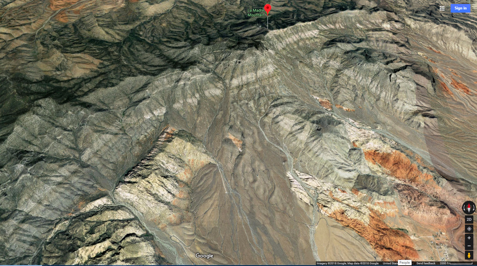
This adventure reaches East La Madre Peak from a parking area on Kyle Canyon Road to the North. Take Hwy 95 North from Las Vegas. Exit left onto Kyle Canyon Road toward Mt. Charleston (around the end of the Northern metro area). In about 3 miles, shortly beyond the edge of the housing and horse ranch area, watch for a small trailhead parking area on the left (South) side of Kyle Canyon Road.
Narrative Guide | East La Madre Peak | La Madre Mountains Wilderness, Nevada
Getting Your Initial Bearings
As you stand in the parking area on Kyle Canyon Road, look to the South to see La Madre Mt. and the peak just to the left on the horizon peaking above the intervening ridges. I at first mistakenly identified the rocky peak to the left as East La Madre Peak. Wrong! That’s Fernande Peak. East La Madre Peak is not visible from the parking area. It’s a bit lower, about 7,000ft, and longer, further to the left. It’s the long summit peak just before the La Madre Ridgeline makes final plunge downward toward the Vegas Metro Area below its Eastern edge.
East La Madre Peak will become visible as soon as you begin heading up the valley toward the La Madre Ridgeline.
Kyle Canyon Road to the Approach Slopes and Ridges
The entire area South of the trailhead parking area on Kyle Canyon Road contains a network of hiking, running and biking trails, including some unpaved roads. These trails will streamline your route to the approach ridges and slopes. Once you leave the roads and trails, you’re on ground seldom traversed, although it is so close to the metro area.
Begin heading South on a pathway/road branching off from the parking area. In less than 100 yards you’ll find yourself at the edge of the massive Harris Springs Canyon Wash. The pathway will angle to the left and easily down into the wash. There’s a high ridgeline on the opposite side of the wash. You want to make your way to the left, down the wash, finally rounding the base of the opposite ridgeline, taking a right turn up the next valley toward the La Madre Ridgeline. A road and paths will streamline your way.
As you head South up that next valley, the East end of the La Madre Ridgeline becomes visible ahead, along with East La Madre Peak, Fernande Peak and La Madre Mountain on the ridgeline. Along that valley, what I call Harris Springs Canyon Ridgeline is the tall ridgeline to your left with Peak 6080 as its high point. That in itself is an awesome adventure and workout! You’ll see Peak 6080 as a reference point during your entire East La Madre Peak adventure.
An unpaved road streamlines your way up the valley toward the La Madre Ridgeline. Incidentally, there’s an opening between Harris Springs Ridgeline and the La Madre Ridgeline. This could form a passage to Summerlin Ridge and Cheyenne Mountain. That’s a future adventure.
Head up the long valley toward the La Madre Ridgeline. At the point where the road splits right and left (left through the passage just mentioned; right along the base of the La Madre Ridgeline), begin watching for an approach slope upward toward the La Madre Ridgeline. There are a number of potential approach slopes and many of the slopes are nice, gradual, rounded hills and ridgelines on a grassy, sage and cactus surface.
The Approach Slopes and Ridges
The series of approach slopes to the La Madre Ridgeline merit future exploration. Each arrives at a different point on the La Madre Ridgeline. The furthest to the East offers the best early views of the Las Vegas Metro Area. I took the next slope just to the West. There are a few additional approach slopes. One leads directly to the West end of East La Madre Peak. An approach gully leads to the deep saddle between East La Madre Peak and Fernande Peak. Two approach slopes further West lead to Fernande Peak and La Madre Mountain. I haven’t tested all these approaches, but they all look like they’d work out at class 2 & 3 level climbing. The approach gully to the saddle looks like it might be a great La Madre Ridgeline crossing as the descent on the opposite side of the La Madre Ridgeline toward Little Red Rock and Damsel Peak looks gradual and class 2-3.
2nd Approach Slope from the East
This slope was gradual with few obstacles. There was one 10ft limestone ledge about half-way up the slope, but this ledge was easy to navigate as there was a nice ramp a bit to the left (East) through the ledge. Continuing beyond, there were a number of high ridges that each promised to be the final intervening ridge before the La Madre Ridgeline. Turns out, the La Madre Ridgeline did not become visible until I crossed the 3rd intervening ridgeline. I headed toward the Eastern edge of the approach slope in order to get a view of the Vegas Metro Area.
Upper Plateau at 6,000ft
There’s a beautiful pine and juniper covered plateau at about 6,000ft on the East end of the approach slope, about the same height as our reference Peak 6080. This plateau presents a spectacular sweeping view of the Las Vegas Valley immediately below. Imagine camping on the plateau with the lights of the city below and the stars above! Of course, bring everything you need (water, food, shelter…though in Early Fall and late Spring you could just sleep under the stars).
Final Approach to East La Madre Peak
Beyond the 6,000ft plateau, the incline continues very gradually until you reach the final approach spur toward East La Madre Peak. That approach spur is pretty obviously the best route to the summit. As you reach the spur, the incline dramatically increases. I found the best route to be weaving up the spur, sometimes hugging the right side, sometimes hugging the left side, sometimes right up the center. The further you go to the right of the spur you’ll end up on a steep loose rock slope. You could navigate this, but staying close to the spur seems more stable. There are stretches where the center of the spur is wide, firm and easy to navigate. But there are rocky sections you want to skirt to the left or right. You can’t stray too far to the left as there is quite a substantial drop-off. It’s not too hard to pick the best weaving route up the spur, finding a class 2 walking approach all the way to the summit of East La Madre Peak.
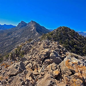
East La Madre Peak Summit Block
East La Madre Peak is nearly a quarter-mile long and fairly horizontal all the way with a few narrow rocky stretches you can easily navigate just below to the right (North). Here’s where all the spectacular views noted above are coming at you simultaneously! The video cover and first slide on this page show the terrain along the La Madre Ridgeline heading West. Just West of East La Madre Peak’s summit block there is a deep saddle to traverse before reaching the rocky Fernande Peak. The ascent to Fernande Peak and La Madre Mountain beyond looks imposing, but perhaps a nice route through the seemingly vertical limestone walls will appear once I’m up there. Beyond La Madre Mountain I have video documented the entire La Madre Ridgeline all the way to the point above La Madre Springs and White Rock Mountain above Red Rock Canyon. See those adventures on this website!
On this day, I turned around and retraced my way back from East La Madre Peak to my starting point on Kyle Canyon Road. Coming soon is the stretch between East La Madre Peak and La Madre Mountain!
Summary
The route to East La Madre Peak is fun, and a total mountaintop experience all the way, once you leave the lower roads and trails to ascend the approach slopes! There are more Southern Nevada wilderness areas in view during this route than nearly any other adventure I’ve made, and the entire route is an easy class 2. This is one of the lowest effort vs. highest return adventures in Southern Nevada! And once you leave the lower roads and trail and begin ascending the approach slopes, it’s like you’re a thousand miles away from civilization. You’re unlikely to see anyone, or even many signs of human passage, except for two or three small stray cairns.


