Overview | Rocky Gorge Loop Trail | Sawmill Trailhead Area | Lee Canyon, Nevada
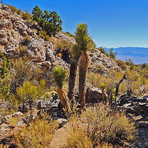
Like a Bonsai Garden
This intimate little gorge is like a desert bonsai garden! Though the loop trail is hidden away in
Lee Canyon with no visible trailheads, it’s well worth the search!
Hidden Trailheads
The
Rocky Gorge Loop Trail is one of the most overlooked trails in
Lee Canyon‘s
Sawmill Trails Network. Neither the clockwise nor the counterclockwise trailheads are marked. You have to know where this trail is or you’ll never find it!
Why is the Rocky Gorge Loop Trail Worth the Effort?
The
Rocky Gorge itself is only around a half-mile in length, though the long loop shown in the video on this page is 12 miles and the short loop pointed out is about 6 miles. Either 6 or 12 miles is a long way to go for a half-mile gorge. Why do I believe it’s worth the effort?
Born and raised in
Portland Oregon, when I hear the word “
Gorge” I think of the spectacular world-famous
Columbia River Gorge. When I think about spectacular limestone-walled canyons, the impressive heights of the
Spring Mountains peaks and their approach routes come to mind. So what’s with this tiny “
Rocky Gorge“?
Rocky Gorge is like an intimate desert bonsai garden. Here you will find plants nestled in the beautiful surrounding limestone walls creating a unique setting you will not experience in either the
Columbia Gorge or the upper
limestone heights of the
Spring Mountains. It’s a peaceful environment where you may just want to sit and meditate as you’re soaking in the surroundings created by blue sky,
gray limestone and green
yucca,
juniper,
pinyon pine and
cacti.
As I’ve previously stood on the
Spring Mountains peaks observing the slopes below, I had no idea those slopes contained such gems, tucked away in the lower canyons. Today’s adventure was a surprising revelation. Standing on the upper heights will never be quite the same after having been immersed in this canyon on the lower slopes.
Dramatic Change in Terrain
Another additional feature of this adventure is the dramatic change in terrain from the taller pines and junipers around the
Sawmill Trailhead and the expansive
Joshua Tree yucca forest on the ridges and below the opening of
Rocky Gorge. The terrain change is similar to what you’d experience traveling from Canada to the deserts of the U.S. Southwest.
Adventure Route Summary
Beginning at the upper
Sawmill Trailhead start out on the
Sawmill Loop Trail counterclockwise, then take a left onto the
Sawmill Loop Trail/
Blue Tree Loop Trail overlapping loops, soon leaving the
Sawmill Loop Trail, now on the
Blue Tree Loop only. Continue to a confusing intersection where you’ll take a left and almost immediate right turn onto the totally unmarked, hidden
Pinyon Pine Eastern loop (counterclockwise). Continue along this Pinyon Pine hidden stretch to a “T” intersection where the
Pinyon Pine Loop Trail takes a left, but you continue straight onto the
Rocky Gorge Loop Trail. The “T” intersection is actually the clockwise trailhead to the
Rocky Gorge Loop Trail.
Now, on the
Rocky Gorge Loop Trail, continue straight, crossing one intersecting road. This trail will take you through
Rocky Gorge, out the lower end and around toward
Lee Canyon Road, than parallel
Lee Canyon Road as you ascend to
Blue Tree Road. Where the trail intersects
Blue Tree Road, you’re at the hidden counterclockwise
Rocky Gorge Loop Trail trailhead. Now turn right onto
Blue Tree Road which is also the
Blue Tree Loop Trail. Take the
Blue Tree Loop Trail back up to the
Sawmill Loop Trail and finally return to your starting point at the
Sawmill Trailhead.
Best Time of Year for This Adventure
The best temperature on the
Sawmill Trails is April through mid-June and September through mid-October. Winter can bring snow that hides already obscure, sometimes confusing trails and Summer can bring dangerously high heat, especially on the lower Sawmill Trails, like the
Rocky Gorge Loop Trail. On the day of this adventure it was the 3rd week in July, with a cool breeze and surprisingly comfortable temperature in the mid-70’s. Don’t count on that during the mid-Summer months! Temperature in Las Vegas was under 100 degrees on this day. If the temperature in Las Vegas is predicted to exceed 100 degrees, the
Sawmill Trails are not advised.
Directions to Start Point | Rocky Gorge Loop Trail | Sawmill Trailhead Area | Lee Canyon, Nevada
Take
Hwy 95 North from Las Vegas and take a left at the
Lee Canyon Road exit (
Hwy 156). Travel up
Lee Canyon Road about 13 miles. Take a right onto the
Sawmill Trailhead Access Road and proceed to the trailhead. Stay left to reach the upper trailhead parking area.
↓ Narrative Guide ↓
Narrative Guide | Rocky Gorge Loop Trail | Sawmill Trailhead Area | Lee Canyon, Nevada
Getting Your Initial Bearings
At the upper
Sawmill Trailhead, look across
Lee Canyon Road to see the impressive limestone heights of
Mummy’s Head. This reference point will always point you back to the trailhead. No matter where you are on the outer
Sawmill Trails, most any high point will reveal the position of
Mummy’s Head. The outer
Sawmill Trails can become faint, sometimes disappearing, unmarked pathways with unmarked off-branching paths. It’s possible to get disoriented. If that happens, head for
Mummy’s Head. You’ll cross one or more trails on the way, and eventually reach
Lee Canyon Road near the
Sawmill Trailhead.
Sawmill Trailhead to the Big, Somewhat Confusing Intersection
Notice the beautiful pinyon pine and juniper forest around the
Sawmill Trailhead. This terrain is going to dramatically change as you descend
Lee Canyon. You’ll see the vegetation gradually becoming smaller,
pinyon pines and
junipers beginning to thin out and die as you approach the lower elevations where
cacti,
yucca and
Joshua Trees thrive. See how plants gradually adjust to lower their exposure to the scorching sunlight and rising heat of the lower elevations. To conserve scarce moisture, they don’t grow as tall. Leaves and needles are smaller, often curved to limit exposure to the sun. Ultimately, the
cacti,
yucca and
Joshua Trees take over. Finally, they too give out to more barren landscapes blanketed with totally barren saltpans.
From the
Sawmill Trailhead, take a right onto the
Sawmill Loop Trail (counterclockwise direction). Take the loop less than a quarter mile to its intersection with the
Blue Tree Loop Trail. At this intersection a right turn would take you to the Lower
Sawmill Equestrian Trailhead. Instead, turn left onto the
Blue Tree Loop Trail which also overlaps the
Sawmill Loop Trail. Continue on these overlapping loops until the
Blue Tree Loop Trail splits off to the right, leaving the
Sawmill Loop Trail.
Continue on the
Blue Tree Loop as it winds around upper ridgelines overlooking
Lee Canyon Road. Keep to the main trail, avoiding a couple unmarked off-branching trails heading down toward
Lee Canyon Road. Eventually, you’ll arrive at a big, somewhat confusing intersection with 5 options, not all clearly marked!
Big, Somewhat Confusing Intersection to Rocky Gorge Clockwise (Western) Hidden Trailhead
You’ll know when you’ve arrived at the big, somewhat confusing intersection. The
Blue Tree Loop Trail continues straight, but as a road. There’s an intersecting road. A right turn takes you down toward
Lee Canyon Road. A left turn takes you up to the ridgeline summit where you would find the
counterclockwise Mud Springs trailhead and
clockwise Pinyon Pine Trailhead. And there is a totally unmarked trail opening ahead and just a little to the left.
Here’s what you need to do at this intersection: Take a quick jog to the left, then immediately turn right onto that obscure, totally unmarked trail opening. That’s the
Pinyon Pine counterclockwise trailhead to the Eastern side of its loop. Continue along the
Pinyon Pine Eastern loop. You’re now in a long gully with low ridgelines above on either side. Notice the vegetation gradually becoming thinner and dryer. In less than a mile you’ll arrive at a “T” intersection which is the clockwise Western hidden trailhead to the
Rocky Gorge Loop Trail!
Rocky Gorge Clockwise (Western) Hidden Trailhead to Rocky Gorge Upper Opening
At the “T” intersection notice a sign post with two pieces of colored tape: One red for
Pinyon Pine Loop Trail and one yellow for
Rocky Gorge Loop Trail. I imagine there were originally arrows pointing which direction each colored trail went, but all pointers are worn off and only the two colored pieces of tape remain.
Continue straight at the “T” intersection signpost. A left turn here would send you off course, continuing on the red-coded
Pinyon Pine Loop Trail‘s hidden Eastern loop.
Congratulations! You’re now on the hidden
Rocky Gorge Loop Trail in the clockwise direction! Since few people know where this trail is, expect it to become fainter and in some places a bit confusing or even briefly disappear. Just know you’re continuing to descend the same gully between the low ridges to your right and left. If you lose the trail, just stop and study the ground for any sign of use. Walk a few widening circles and the trail will reappear ahead.
At one point you will cross an unmarked road. Continue straight across the road, eventually discovering where the trail continues on the other side.
A little later, the
Rocky Gorge Loop Trail will ascend the low ridge to your right (East) and descend into the next gully to the East. Then it will ascend the right (East) side of that gully, descending into yet another gully. Now, in the third parallel gully, you’ll ascend it’s right (East) side, descending into a much larger, fourth parallel gully. This fourth gully is the gully that will eventually become
Rocky Gorge. Plants are now dramatically thinning and you can see
Joshua Trees lining the ridgelines above. They’re gradually taking over!
Through Rocky Gorge
As you proceed down this fourth gully to the East, the ridgelines to your right and left will begin to rise and become more limestone rocky, vertical in places. You’re now in
Rocky Gorge for the next half-mile. Enjoy the desert bonsai environment. It’s like its own little unique world. The surface you are on is also more rocky and you’ll need to step down a few rocky steps, nothing difficult. It never exceeds the difficulty level of walking. The trail itself often disappears in the rocky surface, but the gorge is more narrow. Finding the trail again is just a matter of continuing downward on the path of least resistance between the walls to your right and left until the trail reappears.
It’s pretty obvious when you’ve passed through the lower end of
Rocky Gorge. The surrounding rock walls disappear and become ridges, the gully widens, the surface you’re on is a wider, fine gravel wash and the
Sheep Range is visible ahead in the distance to the East.
Exiting the Gorge Toward Lee Canyon & Blue Tree Roads
As you emerge from the lower opening of
Rocky Gorge watch carefully for the path that will ascend the ridge to your right (East) toward
Lee Canyon Road. You may not actually see a path. I noticed a small cairn (stack of rocks) to the right and thought, this just may be marking where the
Rocky Gorge Loop Trail begins to circle around to the right. I could not see a trail or even a pathway at first. But after exploring around above the cairn, a pathway eventually appeared. This was the continuation of the
Rocky Gorge Loop Trail. Note that cairns can be temporary, and in the future, if this cairn is missing you’ll have a very hard time finding the continuation of the trail. If you miss the trail, just head up the ridge to your right by the time you top that ridge, you’ll likely come across the trail. If not, just aim for
Angel Peak, visible from the top of the ridge and you’ll eventually find the trail, or at least reach
Lee Canyon Road. Angle upward toward
Mummy’s Head once that becomes visible.
Let’s assume you locate the pathway ascending the ridge. At first it’s angling diagonally up the ridge a bit toward the
Sheep Range. Then it rounds the ridgeline summit, turning toward
Mummy’s Head, now visible. At this point, notice an incredible
Joshua Tree forest in the ridges and gullies immediately below (toward the
Sheep Range). Very impressive and beautiful!
The upper ridgeline surface becomes rocky and windswept, the trail at times disappearing. Just stay on the upper ridgeline, noting that you will angle toward and over the next two ridgelines to the East (toward
Lee Canyon Road) before topping the final ridgeline from which you can see
Lee Canyon Road below.
The trail now switchbacks down this final high ridgeline toward
Lee Canyon Road. Cross the wash at the base of the ridgeline where the trail continues toward
Lee Canyon Road, gradually angling to the right and upward until it eventually parallels
Lee Canyon Road, now just a hundred yards or so to the East. You can’t see
Lee Canyon Road, but it’s there off to your left.
The trail eventually winds up a shallow gully, reaching a camp spot on
Blue Tree Road about 50 yards from
Lee Canyon Road. This camp spot on
Blue Tree Road is actually the unmarked counterclockwise entrance to the
Rocky Gorge Loop Trail! There is a reference point here. There’s a large stone with an American flag painted on it. So, by now, you’ve seen both the unmarked, hidden trailheads to the
Rocky Gorge Loop Trail. You’ll never find them without a map!
Alternate Shorter Rocky Gorge Loop from the Lower Blue Tree Loop Trailhead
Blue Tree Road is a short road branching off perpendicularly from
Lee Canyon Road. A left turn at the American flag stone would take you to
Lee Canyon Road. The lower
Blue Tree Loop Trailhead is a right turn across
Lee Canyon Road and about a hundred yards up.
Returning to the Sawmill Trailhead
But let’s assume you’re at the American flag stone on
Blue Tree Road and wanting to return to the
Sawmill Trailhead. In that case, turn right on
Blue Tree Road. You’re now on the fairly well-marked
Blue Tree Loop.
Blue Tree Road will soon angle to the left. You’ll need to cross a low unmarked gully to continue on the
Blue Tree Loop Trail/Road at this point. Basically, it’s running parallel to
Lee Canyon Road and heading toward
Mummy’s Head. Follow the signs and cairns across multiple crossing paths and roads, always continuing up
Lee Canyon above and parallel to
Lee Canyon Road. Where there are intersections, avoid off-branching roads and paths that lead down toward
Lee Canyon Road or upward in the other direction. Watch for cairns and signs to verify you’re continuing on the
Blue Tree Loop.
Eventually, you’ll reach that “Somewhat Confusing Intersection” I pointed out above where you first entered the hidden, unmarked
Pinyon Pine Eastern Loop near the beginning of today’s adventure. From there, just retrace you way back to the
Sawmill Loop and the
Sawmill Trailhead. What a day! You’ve traversed a route few people have been able to find!